This article needs additional citations for verification. Please help improve this article by adding citations to reliable sources. Unsourced material may be challenged and removed. Find sources: "Geography of Zimbabwe" – news · newspapers · books · scholar · JSTOR(October 2014) (Learn how and when to remove this message)
Geography of Zimbabwe
Continent
Africa
Region
Southern Africa
Coordinates
20°S30°E / 20°S 30°E / -20; 30
Area
Ranked 60th
• Total
390,757 km2 (150,872 sq mi)
• Land
99.00%
• Water
1.00%
Coastline
0 km (0 mi)
Borders
3,066 km (Botswana 813 km, Mozambique 1231 km, South Africa 225 km, Zambia 797 km)
Highest point
Inyangani 2,592 m (8,504 ft)
Lowest point
junction of the Runde and Save rivers. 162 m (531 ft)
Longest river
Zambezi River 2,650 km
Largest lake
Lake Kariba 7,770 km2
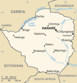
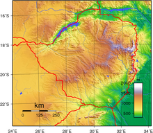
Satellite image of ZimbabweTopography of ZimbabweZimbabwe's cities, main towns, selected villages and archaeological sites, rivers and its highest point
Zimbabwe is a landlocked country in southern Africa lying north of the Tropic of Capricorn.[1] During summer, the whole country experiences warm temperatures as a result of the sun being directly overhead. It straddles an extensive high inland plateau that drops northwards to the Zambezi valley where the border with Zambia is and similarly drops southwards to the Limpopo valley and the border with South Africa.
^"Zimbabwe climate: average weather, temperature, precipitation, when to go, what to pack". www.climatestotravel.com. Retrieved 2023-05-14.
and 29 Related for: Geography of Zimbabwe information
Zimbabwe is a landlocked country in southern Africa lying north of the Tropic of Capricorn. During summer, the whole country experiences warm temperatures...
Zimbabwe (/zɪmˈbɑːbweɪ, -wi/; Shona pronunciation: [zi.ᵐba.ɓwe]), officially the Republic ofZimbabwe, is a landlocked country in Southern Africa, between...
Mozambique, Namibia, South Africa, Zambia, and Zimbabwe. In cultural geography, the island country of Madagascar is often not included due to its distinct...
White Zimbabweans are Zimbabwean people of European descent. In linguistic, cultural, and historical terms, these Zimbabweansof European ethnic origin...
Place names in Zimbabwe, including the name of the country itself, have been altered at various points in history. The name Zimbabwe was officially adopted...
The politics ofZimbabwe occurs in a society deeply divided along lines of race, ethnicity, gender and geography. The ZANU–PF party has historically been...
Great Zimbabwe is a medieval city in the south-eastern hills of the modern country ofZimbabwe, near Lake Mutirikwe and the town of Masvingo. It is thought...
See ISO 3166-2:ZW Internet country code top-level domain: .zw GeographyofZimbabweZimbabwe is: a landlocked country Location: Eastern Hemisphere and Southern...
The president ofZimbabwe is the head of state ofZimbabwe and head of the executive branch of the government ofZimbabwe. The president chairs the national...
countries of South Africa, Lesotho, Eswatini, Zimbabwe and Botswana. A certain sub-tropical woodland ecoregion of Southern Africa has been officially defined...
The national flag ofZimbabwe consists of seven even horizontal stripes of green, gold, red and black with a white triangle containing a red five-pointed...
Zimbabwe Rhodesia (/zɪmˈbɑːbweɪ roʊˈdiːʒə, zɪmˈbɑːbwi roʊˈdiːʒə/), alternatively known as Zimbabwe-Rhodesia, also informally known as Zimbabwe or Rhodesia...
Democratic Republic of the Congo for 1,930 km, Malawi for 837 km, Mozambique for 419 km, Namibia for 233 km, Tanzania for 338 km, Zimbabwe for 797 km, and...
This is a list of cities, towns and villages in Zimbabwe. See also: Place names in Zimbabwe. Chitungwiza Epworth Harare Birchenough Bridge Buhera Cashel...
constituent political entities ofZimbabwe. Zimbabwe currently has ten provinces, two of which are cities with provincial status. Zimbabwe is a unitary state, and...
roughly 2,000 years ago, what would become Zimbabwe was populated by ancestors of the San people. Bantu inhabitants of the region arrived and developed ceramic...
south-west ofZimbabwe, between the Limpopo and Zambezi rivers and are further separated from Midlands by the Shangani River in central Zimbabwe. The region...
spoken, or historically have been spoken, in Zimbabwe. Since the adoption of its 2013 Constitution, Zimbabwe has 16 official languages, namely Chewa, Chibarwe...
The following is a list of holidays in Zimbabwe: Public holidays in Rhodesia, for historical holidays Public holidays are as detailed in the Public Holidays...
as the Zimbabwean War of Liberation, was a civil conflict from July 1964 to December 1979 in the unrecognised country of Rhodesia (later Zimbabwe-Rhodesia...
Zimbabwe Defence Forces (ZDF) are composed of the Zimbabwe National Army (ZNA) and the Air Force ofZimbabwe (AFZ). As a landlocked country Zimbabwe does...
List of bridges in Zimbabwe. Transport in Zimbabwe National Railways ofZimbabweGeographyofZimbabwe List of rivers ofZimbabwe List of crossings of the...
occurring in Zimbabwe, even though the country's contribution to greenhouse gas emissions is very minimal. Climate change is the result of the Earth's...
provided as an overview of and topical guide to geography: Geography – study of Earth and its people. an academic discipline – a body of knowledge given to...
Mashonaland is a region in northern Zimbabwe. It is home to nearly half of the population ofZimbabwe. The majority of the Mashonaland people are from the...
The Republic ofZimbabwe is broken down into 10 administrative provinces, which are divided into 64 districts and 1,970 wards. Bulawayo Harare Chitungwiza...
The following are the telephone codes in Zimbabwe. For calls inside the same geographic numbering area (local calls), dial the Subscriber Number only (this...
Land reform in Zimbabwe officially began in 1980 with the signing of the Lancaster House Agreement, to reverse the distribution of land that resulted...
capital and largest city ofZimbabwe. The city proper has an area of 982.3 km2 (378.7 mi2), a population of 1,849,600 as of the 2022 census and an estimated...
 Global Information