1,710 km2 (659 sq mi) (Bulawayo) - 28,967 sq mi (75,025 km2) (Matabeleland North)
Government
Provincial government, National government
Subdivisions
District
Politics of Zimbabwe
Constitution
Constitutional history
Human rights
Government
President
Emmerson Mnangagwa
Vice-President
Constantino Chiwenga
Kembo Mohadi
Cabinet
Legislature
Parliament
Senate
President
National Assembly
Speaker
Constituencies
Judiciary
Supreme Court
Elections
General
1980 1985 1990 1995 2000 2005 2008 2013 2018 2023
Referendums
2000 2013
Electoral Commission
Political parties
Administrative divisions
Provinces
Districts
Wards
Foreign relations
Ministry of Foreign Affairs and International Trade
Minister: Frederick Shava
Diplomatic missions of / in Zimbabwe
Passport
Visa requirements
Visa policy
v
t
e
Provinces are constituent political entities of Zimbabwe. Zimbabwe currently has ten provinces, two of which are cities with provincial status. Zimbabwe is a unitary state, and its provinces exercise only the powers that the central government chooses to delegate. Provinces are divided into districts, which are divided into wards.
The Constitution of Zimbabwe delineates provincial governance and powers. After constitutional amendments in 1988, provinces were administered by a governor directly appointed by the President of Zimbabwe.[1] Since the 2013 constitutional changes, there are technically no longer provincial governors, though in practice they remain in place as Ministers of State for Provincial Affairs. The 2013 Constitution also calls for the devolution of governmental powers and responsibilities where appropriate, though Zimbabwean opposition parties argue that the central government has yet to comply.[2]
With the establishment of Company rule in Rhodesia in the 1890s, the country was divided into two provinces: Matabeleland in the west and Mashonaland in the east. Under British colonial rule as Southern Rhodesia, the colony was divided into five provinces. Later, the Rhodesian government expanded the number of provinces to seven: Manicaland, Matabeleland North and South, Mashonaland North and South, Midlands, and Victoria (today Masvingo).[3] In the 1980s, Mashonaland North and South were reorganized to become three provinces (Mashonaland Central, East and West). The youngest provinces, Bulawayo and Harare, were created in 1997.
Name
Towns and cities
Established
Population (2022)[4]
Total area[5]
Location
Capital
Largest
km2
mi2
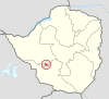
Bulawayo
Bulawayo
1997
665,952
900
347
Harare
Harare
1997
2,427,231
872
337
Manicaland
Mutare
1897[6]
2,037,703
36,459
14,077
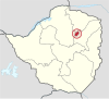
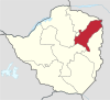
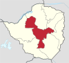
Mashonaland Central
Bindura
1983
1,384,891
28,347
10,945
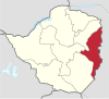
Mashonaland East
Marondera
?
1,731,173
32,230
12,440
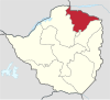
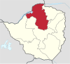
Mashonaland West
Chinhoyi
Kadoma
1983
1,893,584
57,441
22,178
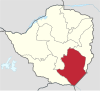
Masvingo
Masvingo
?
1,638,528
56,566
21,840
Matabeleland North
Lupane
Victoria Falls
1973
827,645
75,025
28,967
Matabeleland South
Gwanda
Beitbridge
1973
760,345
54,172
20,916
Midlands
Gweru
?
1,811,905
49,166
18,983
^Bridger, Peter Anthony (1973). Encyclopaedia Rhodesia. College Press.
^Kandemiiri, Jonga (1 March 2016). "MDC-T Urges Zimbabwe to Devolve Power to Provinces". VOA. Retrieved 25 July 2018.
^Passmore, Gloria C. (1972). The National Policy of Community Development in Rhodesia. Department of Political Science, University of Rhodesia. p. 163.
^"Zimbabwe: Provinces, Major Cities & Urban Localities - Population Statistics, Maps, Charts, Weather and Web Information". www.citypopulation.de. Retrieved 28 January 2024.
^Zimbabwe at GeoHive
^"Reports of International Arbitral Awards, Volume XXVIII" (PDF). United Nations.
and 27 Related for: Provinces of Zimbabwe information
Provinces are constituent political entities ofZimbabwe. Zimbabwe currently has ten provinces, two of which are cities with provincial status. Zimbabwe...
The Republic ofZimbabwe is broken down into 10 administrative provinces, which are divided into 64 districts and 1,970 wards. Bulawayo Harare Chitungwiza...
system. List of chief justices ofZimbabwe: Main articles: ProvincesofZimbabwe, Districts ofZimbabweZimbabwe is divided into eight provinces, each administered...
Harare Province, which includes the city of Harare, is the most populous ofZimbabwe's ten provinces, with over two million inhabitants in 2012. Manicaland...
This is a list ofZimbabweanprovinces by Human Development Index as of 2021. "Sub-national HDI - Area Database - Global Data Lab". hdi.globaldatalab.org...
Zimbabwe (/zɪmˈbɑːbweɪ, -wi/; Shona pronunciation: [zi.ᵐba.ɓwe]), officially the Republic ofZimbabwe, is a landlocked country in Southern Africa, between...
The Senate ofZimbabwe is the upper of the two chambers in Zimbabwe's Parliament. It existed from independence in 1980 until 1989, and was re-introduced...
anniversary of the Bahá'ís in Zimbabwe, a year of events across the country culminated with a conference of Bahá'ís from all provincesofZimbabwe and nine...
Assembly ofZimbabwe, previously the House of Assembly until 2013, is the lower house of the Parliament ofZimbabwe. It was established upon Zimbabwe's independence...
corresponding to the country's provinces. Formerly based at Parliament House, Harare, the parliament will move to the New Zimbabwe Parliament Building during...
in southeastern Zimbabwe. It has a population of 1.638 million as of the 2022 census, ranking fifth out ofZimbabwe's ten provinces. Established by the...
Great Zimbabwe is a medieval city in the south-eastern hills of the modern country ofZimbabwe, near Lake Mutirikwe and the town of Masvingo. It is thought...
constituency votes. As part of the election, a new Senate was also elected. 60 members - six for each ofZimbabwe's 10 provinces - were elected by proportional...
Harare and Bulawayo provinces, Manicaland is Zimbabwe's third-most densely populated province. Manicaland was one of five original provinces established in...
independent of central or federal authority, especially in Canada and Pakistan. In other countries, like China or France, provinces are the creation of central...
Zimbabweanprovinces. The province is divided into eight districts: Bindura Mbire Guruve Mount Darwin Rushinga Shamva Mazowe Muzarabani Provincesof Zimbabwe...
area of 54,172 square kilometres (20,916 sq mi), equal to 13.86% of the total area ofZimbabwe. It is the fourth-largest of the country's ten provinces in...
Wikimedia Commons has media related to Mashonaland West. ProvincesofZimbabwe Districts ofZimbabwe "Sub-national HDI - Area Database - Global Data Lab"...
is one of two cities in Zimbabwe that are also provinces. Bulawayo was founded by a group led by Gundwane Ndiweni around 1840 as the kraal of Mzilikazi...
National Heroes Acre National Heroes Acre Districts ofZimbabwe Place names in ZimbabweProvincesofZimbabwe Zimstat. "2012 Population Census National Report"...
area of 872 square kilometres (337 sq mi), equal to 0.22% of the total area ofZimbabwe. It is the second-smallest in area of the country's provinces, after...
 Global Information