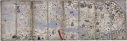
Montage of 8 pages (the third to sixth leaves) of the original 1375 Catalan AtlasDetail of the Catalan Atlas, the first compass rose depicted on a map
The Catalan Atlas (Catalan: Atles català, Eastern Catalan:[ˈatləskətəˈla]) is a medieval world map, or mappa mundi, probably created in the late 1370s or the early 1380s (often conventionally dated 1375),[1][2] that has been described as the most important map of the Middle Ages in the Catalan language,[3][4] and as "the zenith of medieval map-work".[4]
It was produced by the Majorcan cartographic school, possibly by Cresques Abraham, a Jewish book illuminator who was described by a contemporary as a master of mappae mundi as well as of compasses.[5] It was in the royal library of France by 1380, during the reign of King Charles V, and is still preserved in the Bibliothèque nationale de France. The Catalan Atlas originally consisted of six vellum leaves (each circa 64.5 by 50 cm [25.4 by 19.7 in]) folded vertically, painted in various colours including gold and silver.[6] They were later mounted on the front and back of five wooden panels, with the ends enclosed in a leather binding by Simon Vostre c. 1515, restored most recently in 1991. Wear has split each leaf into two.[6]
^Ferandez-Armesto, F.F.R. (1995). The European opportunity. Aldershot, Great Britain ; Brookfield, Vt. : Variorum. p. 291. ISBN 978-0-86078-501-9. The Catalan Atlas is conventionally attributed to 1375, because that year is used as the starting-point for the computation of the Golden Number, but 1376 and 1377 are also mentioned in its accompanying texts; it conforms closely to the description of such an atlas in the French royal library catalogue, dated 1380 [...] The Catalan Atlas can be assigned with some confidence to the late 1370s or the early 1380s.
^The date "1375" is mentioned in several places in the map: Gunn, Geoffrey C. (15 October 2018). Overcoming Ptolemy: The Revelation of an Asian World Region. Rowman & Littlefield. p. 67. ISBN 978-1-4985-9014-3.
^Cite error: The named reference The Jewish Contribution To Civilization was invoked but never defined (see the help page).
^ abCite error: The named reference The late medieval age of crisis and renewal, 1300-1500 was invoked but never defined (see the help page).
^Cite error: The named reference To the Ends of the Earth: 100 Maps that Change the World was invoked but never defined (see the help page).
^ ab"Espagnol 30". Bibliothèque nationale de France (in French). Archived from the original on Feb 8, 2023.
The CatalanAtlas (Catalan: Atles català, Eastern Catalan: [ˈatləs kətəˈla]) is a medieval world map, or mappa mundi, probably created in the late 1370s...
Illustrated Chronicle of Ivan the Terrible) Jani Beg appears in the 1375 CatalanAtlas: the Mongol polity of the Golden Horde is accurately depicted north...
the 1339 chart of Angelino Dulcert, and finding its epitome in the CatalanAtlas of 1375, attributed to Majorcan cartographer Abraham Cresques, contained...
Cresques, Cresques is credited with the authorship of the celebrated CatalanAtlas of 1375. A Majorcan Jew, Cresques was a master map-maker and builder...
war in Venad and captured the city of Kollam. The city appears on the CatalanAtlas of 1375 CE as Columbo and Colobo. The map marks this city as a Christian...
vertical stripe according to the CatalanAtlas of c. 1375: in the depiction of the Delhi Sultanate in the CatalanAtlas Kadoi, Yuka (2010). "On the Timurid...
pp. 61–62. Massing 1991, pp. 31, 32 n60. Siebold, Jim (2015). "The CatalanAtlas (#235)". My Old Maps. Retrieved 12 August 2016. *Barry, Phillips; Anderson...
Catalan charts or Catalan portolans are portolan charts in the Catalan language. Portolan charts are a type of medieval and early modern map that focuses...
same expression was used in flags as well. Eastern Mongol flags in the CatalanAtlas Standards with a golden crescent are mentioned in different historical...
influenced European cartography, leading to the introduction of the CatalanAtlas and the Fra Mauro map. Marco Polo was born around 1254 in Venice, but...
inclusion in Marino Sanuto's Liber Secretorum Fidelium Crucis. The Catalan World Atlas was produced by the Majorcan cartographic school and is attributed...
services company and an insurance company, both located in Taiwan. "CatalanAtlas. The Cresques Project - Panel VI". www.cresquesproject.net. Cavallo...
vertical stripe according to the CatalanAtlas (c. 1375): in the depiction of the Delhi Sultanate in the CatalanAtlas Kadoi, Yuka (2010). "On the Timurid...
vertical stripe according to the CatalanAtlas (c. 1375): in the depiction of the Delhi Sultanate in the CatalanAtlas In medieval Persian manuscripts...
implicit circle. The cartographer Cresques Abraham of Majorca, in his CatalanAtlas of 1375, was the first to draw an ornate compass rose on a map. By the...
[ancient trading city in North Africa], we find Gunuia, and in the Catalanatlas of 1375 as Ginyia. A passage in Leo [Africanus] (vol. III, 822) points...
Noah's Ark on Ararat Chronica Majora (c. 1240–1253) by Matthew Paris CatalanAtlas, c. 1375 by Abraham Cresques Erdapfel (c. 1490) by Martin Behaim Arca...
Catalan (/ˈkætələn, -æn/ KAT-ə-lən, -lan or /ˌkætəˈlæn/ KAT-ə-LAN; autonym: català, Eastern Catalan: [kətəˈla]), known in the Valencian Community and...
the Anatolian Turkish Beylik of the House of Candar according to the CatalanAtlas of 1375 1914–1952 Flag of British Nigeria 1948 Flag of Israel In 1354...
Sunni Muslim dynasties Photographic extract: Mamluk Sultanate in the CatalanAtlas (1375) Rabbat 2001, p. 69. Fischel 1967, p. 72. Turan, Fikret; Boeschoten...
April 2010. Retrieved 2010-03-31. Liščák, Vladimír (2017). "Mapa mondi (CatalanAtlas of 1375), Majorcan cartographic school, and 14th century Asia" (PDF)...
Mansa Musa, ruler of the Mali Empire in the 14th century, from the 1375 CatalanAtlas. The label reads: This Black Lord is called Musse Melly and is the sovereign...
the brothers Domenico and Francesco Pizzigano. A few years later, the CatalanAtlas of 1375 shows the Canaries almost completely and accurately mapped (only...
Hippolytus's Treatise on Christ and Antichrist, part 2 Origen 1872, p. 386 "CatalanAtlas. The Cresques Project – Panel VI". www.cresquesproject.net. "CHURCH...
 Global Information