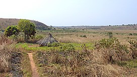
The Adamawa Plateau (French: Massif de l'Adamaoua) is a plateau region in west-central Africa stretching from south-eastern Nigeria through north-central Cameroon (Adamawa and North Provinces) to the Central African Republic.[1] The part of the plateau that lies in Nigeria is more popularly known as Gotel Mountains.
The Adamawa Plateau is the source of many waterways, including the Benue River. The average elevation is about 3,300 feet (1,000 meters),[2] but elevations can reach as high as 8,700 feet (2,700 meters).[1] It is important for its deposits of bauxite.[1] The vegetation is mostly savanna. The endangered toad Amietophrynus djohongensis is known to exist in the wild only in the Cameroonian part of the Adamawa Plateau.[3][4]
The plateau is sparsely populated, and cattle raising is the main occupation in the area.[2] The province and plateau were named after Fulani Muslim leader Modibo Adama, whose jihads significantly affected the population of the area.[2]
^ abcd"Encyclopædia Britannica - Adamawa Plateau". Archived from the original on 15 October 2007. Retrieved September 15, 2007.
^ abc"MSN Encarta - Adamawa Plateau". Archived from the original on 2009-11-02. Retrieved September 15, 2007.
^Joger, U.; Tandy, M. & Amiet, J.-L. (2004). "Amietophrynus djohongensis". IUCN Red List of Threatened Species. 2004. IUCN: e.T54630A11178521. doi:10.2305/IUCN.UK.2004.RLTS.T54630A11178521.en.
^Frost, Darrel R. (2015). "Amietophrynus djohongensis (Hulselmans, 1977)". Amphibian Species of the World: an Online Reference. Version 6.0. American Museum of Natural History. Retrieved 23 October 2015.
The AdamawaPlateau (French: Massif de l'Adamaoua) is a plateau region in west-central Africa stretching from south-eastern Nigeria through north-central...
Shebshi ranges) and the AdamawaPlateau, crossed by valleys and rivers, most notably the Benue and Gongola rivers. The lowlands of Adamawa are part of the West...
Caliphate. Adama's emirate (known as the Adamawa Emirate) was divided into districts under governors; the AdamawaPlateau fell into the Ngaoundéré subdivision...
Adamawa or Adamaua may refer to : AdamawaPlateau, which rises in Nigeria, cuts across Cameroon, and terminates in the Central African Republic Present...
Cameroon Plateau. The plateau gives way to the AdamawaPlateau to the northeast, which is a larger but less accidented region. The core of the plateau is made...
The Adamawa Wars (1899–1907) were initially a series of military expeditions and border conflicts between the German Schutztruppe in Kamerun and the Fula...
areas south of the Adamawaplateau near Tibati, in the South, to the Diamare, in the north, from the slopes of the Bamenda-Adamawa-Mandara Highlands in...
The Adamawa /ædəˈmɑːwə/ languages are a putative family of 80–90 languages scattered across the AdamawaPlateau in Central Africa, in northern Cameroon...
(8,200 ft). The plateau gives way to the AdamawaPlateau to the northeast, a larger but less rugged region. The Western High Plateau features several...
dominant geographical feature of Cameroon. The plateau lies south of the AdamawaPlateau and southeast of the Cameroon Range. It slopes south and west until...
geographical features in Nigeria include the AdamawaPlateau, Mambilla Plateau, Jos Plateau, Obudu Plateau, the Niger River, Benue River, and Niger Delta...
Cameroonian Highlands forests ecoregion. The southern plateau rises northward to the grassy, rugged AdamawaPlateau. This feature stretches from the western mountain...
towards the Mambila Plateau, and north to the Bamenda Highlands. It continues northeast along the western flank of the AdamawaPlateau to Tchabal Gangdaba...
The Benue River is fed by multiple tributaries originating in the AdamawaPlateau; many of the highest tributaries are seasonal streams. The Benue is...
decreased between 4,500 and 1,300 years ago. In the AdamawaPlateau (Cameroon), the Ubangui Plateau (Central African Republic) and the Cameroon Volcanic...
Cameroon spoken by three people (in 1995) at the village of Boung on the AdamawaPlateau. It is remembered best by one speaker who learned the language at a...
provinces was reduced to 13 in 1911, and 12 after World War I. In 1926 Adamawa and Plateau became new provinces. The provinces and divisions in 1945, with the...
a total length of 464.5 km. The Sanaga River has its source at the AdamawaPlateau. It is formed by the confluence of the Djérem and Lom Rivers in the...
communities settled in the highlands of the Jos Plateau, the Western High Plateau of Bamenda, and AdamawaPlateau of Nigeria and the Cameroons. These are the...
of the lake is seasonal. Most of the precipitation comes from the AdamawaPlateau in the south of the basin, which is transported to the lake basin through...
are hills and mountains, which form the Mambilla Plateau, the highest plateau in Nigeria. This plateau extends through the border with Cameroon, where...
defense as he marched toward the capital, while the Germans conquered Adamawa. As the British approached the city of Sokoto, the new Sultan Muhammadu...
Darfur at up to 3,088 metres (10,131 ft) in height. The AdamawaPlateau, Jos Plateau, Biu Plateau, and Mandara Mountains lie to the south. To the west the...
meaning 'Mother of Waters’ in the Batta language. It rises in the AdamawaPlateau of northern Cameroon, from where it flows west, and through the town...
 Global Information