 Global Information
Adamawa State information
Adamawa State
Lesdi Adamaawa (Adamawa Fulfulde) | |
|---|---|
State | |
| Names transcription(s) | |
| • Fulfulde | لٜسْدِ عَدَمَاوَ 𞤤𞤫𞤧𞤣𞤭 𞤢𞤣𞤢𞤥𞤢𞥄𞤱𞤢 |
 | |
 Flag  Seal | |
| Nickname: Land of Beauty/UBA | |
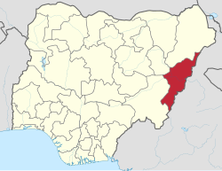 Location of Adamawa State in Nigeria | |
| Coordinates: 9°20′N 12°30′E / 9.333°N 12.500°E | |
| Country | |
| Established | August 27, 1991 |
| Named for | Modibbo Adama |
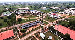
| Capital | Yola |
| Government | |
| • Body | Government of Adamawa State |
| • Governor | Ahmadu Umaru Fintiri (PDP) |
| • Deputy Governor | Kaletapwa Farauta (PDP) |
| • Legislature | State House of Assembly |
| • Senators | C: Iya Abbas (PDP) N: Amos Yohanna (PDP) S: Binos Dauda Yaroe (PDP) |
| • Representatives | List |
| Area | |
| • Total | 36,917 km2 (14,254 sq mi) |
| Highest elevation (Mount Dimlang) | 2,042 m (6,699 ft) |
| Population (2006) | |
| • Total | 3,178,950 |
| • Estimate (2022) | 4,902,100[1] |
| • Density | 86/km2 (220/sq mi) |
| Time zone | UTC+1 (GMT) |
| Postal code | 640001 |
| Dialing Code | +234 |
| Geocode | NG-AD |
| GDP (2021) | ₦2.66 trillion[2] |
| HDI (2019) | 0.488[3] low · 27th of 37 |
| Website | www.adamawastate.gov.ng |
Adamawa State (Fulfulde: Lesdi Adamaawa, لٜيسْدِ عَدَمَاوَ, 𞤤𞤫𞤧𞤣𞤭 𞤢𞤣𞤢𞤥𞤢𞥄𞤱𞤢) is a state in the North-East geopolitical zone of Nigeria, bordered by Borno to the northwest, Gombe to the west for 95 km, and Taraba to the southwest for about 366 km, while its eastern border forms part of the national border with Cameroon across the Atlantica Mountains for about 712 km. It takes its name from the historic emirate of Adamawa, with the emirate's old capital of Yola, serving as the capital city of Adamawa state. The state is one of the most heterogeneous in Nigeria, with over 100 indigenous ethnic groups. It was formed in 1991, when the former Gongola state was divided into Adamawa and Taraba states.[4][5] Since it was carved out of the old Gongola State in 1991 by the General Ibrahim Badamsi Babangida military regime, Adamawa State has had 10 men, both military and civilian, controlling the levers of power, who played crucial roles in transforming the state into what it is today.[6]
Of the 36 states in Nigeria, Adamawa state is the eighth largest in area, but the thirteenth least populous with an estimated population of about 4.25 million as of 2016.[7] Geographically, the state is mainly composed of the highlands of mountains (the Atlantika, Mandara, and the Shebshi ranges) and the Adamawa Plateau, crossed by valleys and rivers, most notably the Benue and Gongola rivers. The lowlands of Adamawa are part of the West Sudanian savanna in the north and the wetter Guinean forest–savanna mosaic in parts of the south, while elevated areas are parts of the Mandara Plateau mosaic and Cameroonian Highlands forests ecoregions. In the extreme south of the state is part of the Gashaka Gumti National Park, a large wildlife park that contains large populations of bushbuck, African buffalo, patas monkey, black-and-white colobus, giant pangolin, and hippopotamus along with some of Nigeria's last remaining Nigeria-Cameroon chimpanzee, African leopard, and African golden cat populations.[8][9]
What is now Adamawa state has been inhabited for years by various ethnic groups, including the Bwatiye (Bachama), Bali, Bata (Gbwata), Gudu, Mbula-Bwazza, and Nungurab (Lunguda) in the central region; the Kamwe in the north and central region; the Jibu in the far south; the Kilba, Marghi, Waga, and Mafa in the north, and the Mumuye in the south, while the Fulani live throughout the state—often as nomadic herders. Adamawa state is also religiously diverse as about 50% of the population is Sunni Muslim and 40% is Christian (mainly Lutheran, EYN, ECWA, and Pentecostal), while the remaining 10% are adherents of traditional ethnic religions.[10][11]
The Adamawa state, formed in the 1800s by the Fulani jihad, was divided between Germany and the British Empire in the Adamawa Wars. The British-controlled area was incorporated into the Northern Nigeria Protectorate, which later became British Nigeria. In 1961, it became an independent state. The state's economy relies on livestock and crops, but the Boko Haram insurgency has impacted development. The state was merged with Nigeria in 1961.[12]
Originally, modern-day Adamawa State was a part of the post-independence Northern Region until 1967 when the region was split and the area became part of the North-Eastern State. After the North-Eastern state was split in 1976, Gongola State was formed on 3 February 1976 alongside ten other states. Fifteen years after statehood, Gongola was split with the state's south becoming Taraba State while its north became Adamawa State.
As an agriculturally-based state, the Adamawa State economy mainly relies on livestock and crops, such as cotton, groundnuts, millet, cassava, guinea corn, and yams. Due to the Boko Haram insurgency affecting development in the state,[12] Adamawa has the eleventh lowest Human Development Index in the country but as the insurgency has abated since 2016 due to terrorist infighting,[13] development has been renewed.[3][14]
- ^ "Adamawa State: Subdivision". www.citypopulation.de.
- ^ "States of States 2022 Edition" (PDF). Archived from the original on March 31, 2023. Retrieved March 19, 2023.
{{cite web}}: CS1 maint: bot: original URL status unknown (link) - ^ a b "Human Development Indices". Global Data Lab. Retrieved December 15, 2021.
- ^ "This is how the 36 states were created". Pulse.ng. October 24, 2017. Retrieved December 15, 2021.
- ^ "Adamawa State | Zaccheus Onumba Dibiaezue Memorial Libraries". zodml.org. Retrieved November 6, 2022.
- ^ vanguard (February 3, 2012). "Adamawa's past men of power". Vanguard News. Retrieved November 6, 2022.
- ^ "Population 2006-2016". National Bureau of Statistics. Retrieved December 14, 2021.
- ^ Sani Kona, Lawal (January 20, 2016). "Photos: Can helping local people save an embattled Nigerian park?". Mongabay. Retrieved December 15, 2021.
- ^ Briggs, Helen (February 23, 2018). "Wildlife secrets of Nigeria's last wilderness". BBC News. Retrieved December 15, 2021.
- ^ Roelofs, Portia (November 2017). "Civil Society, Religion and the State: Mapping of Borno and Adamawa" (PDF). Abuja: Deutsche Gesellschaft für Internationale Zusammenarbeit. Retrieved January 18, 2022.
- ^ Nwankwo, Cletus Famous (March 27, 2019). "Religion and Voter Choice Homogeneity in the Nigerian Presidential Elections of the Fourth Republic". Statistics, Politics and Policy. 10: 1–25. doi:10.1515/spp-2018-0010. S2CID 159290972. Retrieved January 19, 2022.
- ^ a b "Nigeria declares 'massive' military campaign on borders". BBC News. May 15, 2013. Retrieved June 6, 2013.
- ^ Al-Tamimi, Aymenn Jawad (August 5, 2018). "The Islamic State West Africa Province vs. Abu Bakr Shekau: Full Text, Translation and Analysis". Archived from the original on August 17, 2018. Retrieved August 17, 2018.
- ^ "Celebrating the Return of Peace in Nigeria's Adamawa State". USAID. July 12, 2021. Archived from the original on December 15, 2021. Retrieved December 15, 2021.