Global Information Lookup Global Information

Actual Ground Position Line information


UN map showing Siachen in white. Line between the green and white area is the "Actual Ground Position Line" (AGPL). The white area east of the AGPL is held by India.
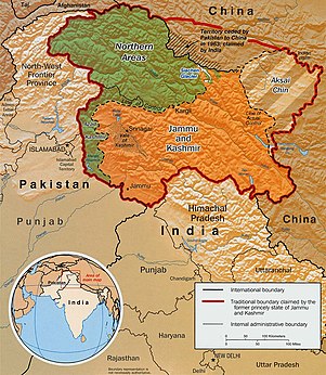
Indo-Pak mutually-agreed undisputed "International Border" (IB) in the black line, Indo-Pak "Line of Control" (LoC) in black dotted line in the north and west, Indo-Sino "Line of Actual" (LAC) in black dotted line in the east, Indo-Pak line across Siachen in north is "Actual Ground Position Line" (AGPL). The areas shown in green are the two Pakistani-controlled areas: Gilgit–Baltistan in the north and Azad Kashmir in the south. The area shown in orange is the Indian-controlled territories of Jammu and Kashmir, and Ladakh, and the diagonally-hatched area to the east is the Chinese-controlled area known as Aksai Chin. "Territories ceded by Pakistan to China claimed by India" in the north is Shaksgam (Trans-Karakoram Tract).
UN map of the Line of Control, which ends at "Point NJ980420" (Point NJ9842). The "Actual Ground Position Line" (AGPL) of the Siachen Glacier begins here. Nubra River valley and Siachen glaciers held by India, along with Bilafond La and Sia La. The Masherbrum Range, Baltoro Glacier, Baltoro Glacier, Baltoro Muztagh and K2 are held by Pakistan.

The Actual Ground Position Line (AGPL) divides current positions of Indian and Pakistani military posts and troops along the entire 110 kilometres (68 mi) long frontline in the disputed region of Siachen Glacier.[1][2][3][4] AGPL generally runs along the Saltoro Mountains range, beginning from the northernmost point of the (LOC) at Point NJ 9842 and ending in the north on the Indira Ridge at the India-China-Pakistan LAC tripoint near Sia Kangri about 4 km (2.5 mi) northwest of Indira Col West, with peaks in excess of 7,000 m (23,000 ft) and temperatures ranging to around −55 °C (−67 °F).[5][6] India gained control of 1,000 square miles (2,600 km2) of disputed territory in 1984 because of its military operations in Siachen.[7][8] A cease-fire was announced in 2003.[9][10][11]

India has at least 108 forward military outposts and artillery observation posts in this area where temperature goes down to −86 °C (−123 °F) during winters with icy 300 km/h (190 mph) blizzards.[citation needed]Bana Top (6,200 metres (20,500 ft)) is the highest post and requires an 80-kilometre (50 mi) trek that takes up to 20 days for troops to reach. Pahalwan Post (6,100 metres (20,000 ft)), and Indira Col (5,800 metres (19,000 ft)), are other high posts. India has two major bases, each with a brigade strength of five to eight battalions supported by additional artillery, air defence, engineer and other logistic units: Thoise which serves the southern Siachen sector, and Siachen Base Camp which serves the northern and middle sectors of Siachen.[12] Kumar Post, a logistics subbase of Siachen Base Camp, is a 60-kilometre (37 mi) 9-day return trek from Siachen Base camp towards Indira Col.[13] India has significant tactical advantage as it occupies most of the higher peaks on the Saltoro Mountain Range in the western sector of Siachen. The Pakistani Army hold posts at lower heights on the western slopes of the spurs of the Saltoro Ridge. Pakistan has not been able to scale the crest of the Saltoro Range occupied by India.[12] Each post has an artillery officer who are deployed in the rotation of 45 days.[14] The average temperature is between minus 25°C during day and minus 55°C during the night.[15] As of 2013, Siachen operations cost INR 3,000 crore annually where over 850 Indian and over 1,800 Pakistani soldiers have died, mostly not in combat, but due to the weather conditions.[12]

Till 2013, 26 decorations have been awarded to the Indian soldiers in this sectors, including a Paramvir Chakra (PVC), five Mahavir Chakra and 20 Vir Chakra to 11 officers and 15 OR of which nine are posthumous. Additionally, many more Kirti Chakra, Shaurya Chakra, Sena Medal and Vayu Sena Medal have been awarded in this sectors.[12]

The actual India-Pakistan boundary is divided into four types of borders: disputed Sir Creek (SC) riverine border, mutually agreed India–Pakistan International Border (IB) from north of Sir Creek to north of Dhalan near Jammu, LoC across disputed Kashmir and Ladakh regions from north of Dhalan in India and west of Chicken's Neck in Pakistan to Point NJ9842, and Actual Ground Position Line (AGPL) across Siachen from Point NJ9842 to Indira Col West. Siachen lies south of the Shaksgam ceded by Pakistan to China via the 1963 Sino-Pakistan Agreement but also claimed by India[11] and Aksai Chin held by China since 1962 but also claimed by India. The Shaksgam Tract, controlled by China, is located north of the Saltoro mountain range from the Apsarasas Kangri Range to 90 km (56 mi) northwest of K2.[16]

  1. ^ The fight for Siachen
  2. ^ "The endless India-Pakistan sabre-rattling over Siachen glacier and the Line of Control can be resolved by turning the area into a peace park for glacial and weather studies, by B G Verghese, and more from Asian Conversations and Dancing Wolf Media". Archived from the original on 2015-04-12. Retrieved 2015-04-07.
  3. ^ They shall not pass
  4. ^ "Bullish on siachen". Archived from the original on 2014-02-22. Retrieved 2014-02-17.
  5. ^ "Revisiting Siachen after the Ladakh stand-off".
  6. ^ Cite error: The named reference controlall1 was invoked but never defined (see the help page).
  7. ^ Desmond/Kashmir, Edward W. (31 July 1989). "The Himalayas War at the Top Of the World". Time. Archived from the original on 14 January 2009. Retrieved 11 October 2008.
  8. ^ Desmond, Edward W. (31 July 1989). "The Himalayas War at the Top Of the World". Time. Archived from the original on 14 January 2009. Retrieved 11 October 2008.
  9. ^ Watson, Paul (26 November 2003). "India and Pakistan Agree to Cease-Fire in Kashmir". Los Angeles Times. Archived from the original on 27 April 2017. Retrieved 27 April 2017.
  10. ^ Kapadia, Harish (1999). Across Peaks & Passes in Ladakh, Zanskar & East Karakoram. New Delhi, India: Indus Publishing Company. pp. 94, 185–87. ISBN 81-7387-100-0.
  11. ^ a b "Pakistan: Signing with the Red Chinese". Time. 15 March 1963. Retrieved 11 January 2020.
  12. ^ a b c d 30 years of the world’s coldest war, The Tribune, 13 April 1984.
  13. ^ Siachen Glacier open to tourists! Everything you must know before visiting world’s highest battlefield, Financial Express, 26 October 2019.
  14. ^ Haryanvi Meghdoot who defended the most challenging post in Siachen, The Tribune, 9 Nov 2019.
  15. ^ Everyday is a story: Army officers recall their time at Siachen Glacier, Indian Express, 14 Feb 2016.
  16. ^ R Baghela and M Nüsserab, 2015, Securing the heights: The vertical dimension of the Siachen conflict between India and Pakistan in the Eastern Karakoram, Political Geography (journal), Volume 48, Pages 24–36.

and 26 Related for: Actual Ground Position Line information
Request time (Page generated in 0.8973 seconds.)

Actual Ground Position Line

Last Update:

The Actual Ground Position Line (AGPL) divides current positions of Indian and Pakistani military posts and troops along the entire 110 kilometres (68 mi)...

Word Count : 2366

List of mountain peaks of Ladakh

Last Update:

North and East and Line Of Control (LOC) and The India–Pakistan AGPL Actual Ground Position Line. That divides current positions of Indian and Pakistani...

Word Count : 202

Saltoro Mountains

Last Update:

Pakistani side of the Saltoro Range, which generally follows the Actual Ground Position Line (AGPL). Saltoro Kangri peak, Saltoro River, and Saltoro Valley...

Word Count : 891

Line of Actual Control

Last Update:

The Line of Actual Control (LAC), in the context of the Sino-Indian border dispute, is a notional demarcation line that separates Indian-controlled territory...

Word Count : 4934

Saltoro Valley

Last Update:

battleground and a disputed territory between India and Pakistan. The Actual Ground Position Line (AGPL) divides the region held by India and Pakistan in the disputed...

Word Count : 459

Bilafond La

Last Update:

Actual Ground Position Line between India and Pakistan, the Indian Army maintains a presence to defend their position. Near the AGPL (Actual Ground Position...

Word Count : 653

Thoise Air Force Station

Last Update:

interior to Siachen, a glacier, helipad and battleground near the Actual Ground Position Line between India and Pakistan. Thoise is nearly 16 km from Hundar...

Word Count : 652

Chumik Glacier

Last Update:

Chumik Kangri Borders Actual Ground Position Line (AGPL) India–Pakistan International Border {IB) Line of Control {LoC) Line of Actual Control (LAC) Sir Creek...

Word Count : 418

Sia La

Last Update:

ends at LAC Borders Actual Ground Position Line (AGPL) India–Pakistan International Border {IB) Line of Control {LoC) Line of Actual Control (LAC) Sir Creek...

Word Count : 396

NJ9842

Last Update:

India-Pakistan cease fire line in Kashmir known as the Line of Control (LoC). The India–Pakistan AGPL (Actual Ground Position Line), begins from the NJ9842...

Word Count : 1069

Indira Col

Last Update:

the tripoint of India, Pakistan, and China. The India-Pakistan Actual Ground Position Line (AGPL) in the Siachen area ends near the pass. It is possible...

Word Count : 1401

Operation Meghdoot

Last Update:

Indira Col Borders Actual Ground Position Line (AGPL) India–Pakistan International Border (IB) Line of Control (LoC) Line of Actual Control (LAC) Sir Creek...

Word Count : 2130

Operation Rajiv

Last Update:

Army operation that aimed to capture a high point along the Actual Ground Position Line (AGPL) on the Siachen Glacier in June 1987. Prior to this operation...

Word Count : 2521

Saltoro Kangri

Last Update:

located in the remote reaches of the Karakoram. It lies on the Actual Ground Position Line, dividing Indian-controlled territory in the Siachen region from...

Word Count : 665

Operation Safed Sagar

Last Update:

ends at LAC Borders Actual Ground Position Line (AGPL) India–Pakistan International Border (IB) Line of Control (LoC) Line of Actual Control (LAC) Sir Creek...

Word Count : 743

Ghent Kangri

Last Update:

Karakoram range. It is located west of the Siachen Glacier near the Actual Ground Position Line between India and Pakistan. Ghent Kangri was first climbed on...

Word Count : 285

Line of Control

Last Update:

media related to Line of Control. India–Pakistan relations Transport between India and Pakistan Actual Ground Position Line – the line of separation near...

Word Count : 4442

Borders of India

Last Update:

nation, Afghanistan, as part of its claim of the Kashmir region (see Durand Line). Maritime borders of India are the maritime boundary recognized by the United...

Word Count : 2283

AGPL

Last Update:

AGPL may refer to: Actual Ground Position Line, the current line dividing Indian and Pakistani forces in the Siachen Glacier GNU Affero General Public...

Word Count : 72

Siachen conflict

Last Update:

their respective posts is being increasingly referred to as the Actual Ground Position Line (AGPL). Despite the high cost India maintains presence, as Pakistani...

Word Count : 6864

Karakoram Pass

Last Update:

of the pass near Indira Col in the Siachen Muztagh, where the Actual Ground Position Line between Indian and Pakistani forces meets the border with China...

Word Count : 902

Siachen Glacier

Last Update:

Hodgson Baltoro Glacier Saltoro Kangri Sia La Bilafond La Gyong La Actual Ground Position Line 2016 Siachen Glacier avalanche Siachen Muztagh From map: "THE...

Word Count : 4196

Indian Astronomical Observatory

Last Update:

Actual Ground Position Line (AGPL), India-Pakistan border across Siachen region Line of Actual Control (LAC), India-China border across Ladakh Line of...

Word Count : 2028

Gyong La

Last Update:

Pakistan. Borders Actual Ground Position Line (AGPL) India–Pakistan International Border (IB) Line of Control (LoC) Line of Actual Control (LAC) Sir Creek...

Word Count : 872

Chulung

Last Update:

Chulung glacier, west of map Point NJ9842 on India-Pakistan Actual Ground Position Line (AGPL) Chulung language, a Kiranti language spoken in Nepal Chulung...

Word Count : 85

Tourism in Ladakh

Last Update:

point Borders With Pakistan AGPL: Actual Ground Position Line, India-Pakistan border across Siachen region. LOC: Line of Control, India-Pakistan border...

Word Count : 4314

PDF Search Engine © AllGlobal.net