76 km (47 mi) using the longest route as is done when determining river lengths or 70 km (43 mi) if measuring from Indira Col[2]
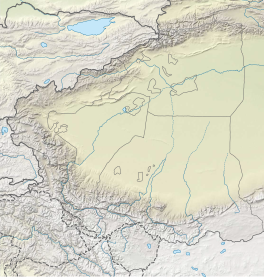
The Siachen Glacier is a glacier located in the eastern Karakoram range in the Himalayas at about 35°25′16″N77°06′34″E / 35.421226°N 77.109540°E / 35.421226; 77.109540, just northeast of the point NJ9842 where the Line of Control between India and Pakistan ends.[3][4] At 76 km (47 mi) long, it is the longest glacier in the Karakoram and second-longest in the world's non-polar areas.[5] It falls from an altitude of 5,753 m (18,875 ft) above sea level at its head at Indira Col on the India–China border down to 3,620 m (11,875 ft) at its terminus. The entire Siachen Glacier, with all major passes, has been under the administration of India as part of the union territory of Ladakh, located in the Kashmir region since 1984.[6][7][8][9] Pakistan maintains a territorial claim over the Siachen Glacier[10] and controls the region west of Saltoro Ridge, lying west of the glacier,[11] with Pakistani posts located 1 km below more than 100 Indian posts on the ridge.[12][13]
The Siachen Glacier lies immediately south of the great drainage divide that separates the Eurasian Plate from the Indian subcontinent in the extensively glaciated portion of the Karakoram sometimes called the "Third Pole". The glacier lies between the Saltoro Ridge immediately to the west and the main Karakoram range to the east. The Saltoro Ridge originates in the north from the Sia Kangri peak on the China border in the Karakoram range. The crest of the Saltoro Ridge's altitudes range from 5,450 to 7,720 m (17,880 to 25,330 feet). The major passes on this ridge are, from north to south, Sia La at 5,589 m (18,336 ft), Bilafond La at 5,450 m (17,880 ft), and Gyong La at 5,689 m (18,665 ft). The average winter snowfall is more than 1000 cm (35 ft) and temperatures can dip to −50 °C (−58 °F). Including all tributary glaciers, the Siachen Glacier system covers about 700 km2 (270 sq mi).
^Desmond/Kashmir, Edward W. (31 July 1989). "The Himalayas War at the Top of the World". Time. Archived from the original on 14 January 2009. Retrieved 11 October 2008.
^Dinesh Kumar (13 April 2014). "30 Years of the World's Coldest War". The Tribune. Chandigarh, India. Retrieved 18 April 2014.
^Cite error: The named reference Lyon was invoked but never defined (see the help page).
^"The Tribune, Chandigarh, India – Opinions". The Tribune.
^Siachen Glacier is 76 km (47 mi) long; Tajikistan's Fedchenko Glacier is 77 km (48 mi) long. The second longest in the Karakoram Mountains is the Biafo Glacier at 63 km (39 mi). Measurements are from recent imagery, supplemented with Russian 1:200,000 scale topographic mapping as well as the 1990 "Orographic Sketch Map: Karakoram: Sheet 2", Swiss Foundation for Alpine Research, Zurich.
^Gauhar, Feryal Ali; Yusuf, Ahmed (2 November 2014). "Siachen: The place of wild roses". Retrieved 4 August 2017.
^North, Andrew (12 April 2014). "Siachen dispute: India and Pakistan's glacial fight". BBC. Retrieved 4 August 2017.
^"India gained control over Siachen in 1984". The Times of India. 9 April 2012. Retrieved 4 August 2017.
^"Blog: The Siachen Story, Then And Now". NDTV.com.
^Siddiqui, Naveed (4 August 2020). "In landmark move, PM Imran unveils 'new political map' of Pakistan". Dawn. Retrieved 5 August 2020.
^Gokhale, Nitin A (2015). Beyond NJ 9842: The SIACHEN Saga. Bloomsbury Publishing. p. 364. ISBN 9789384052263.
^Service, Tribune News. "Life & death in world's highest combat zone". Tribuneindia News Service.
^"Siachen deaths harden resolve to hold glacier: Army chief". Hindustan Times. 18 February 2016.
The SiachenGlacier is a glacier located in the eastern Karakoram range in the Himalayas at about 35°25′16″N 77°06′34″E / 35.421226°N 77.109540°E /...
The Siachen conflict, sometimes referred to as the SiachenGlacier conflict or the Siachen War, was a military conflict between India and Pakistan over...
The SiachenGlacier Medal is awarded for service in the Siachen conflict along India's northern border with Pakistan. Awarded to the Indian Air Force...
codename for the Indian Army operation to take full control of the SiachenGlacier in Ladakh). Executed on the morning of 13 April 1984 in the highest...
the SiachenGlacier, the second-longest non-polar glacier in the world. In earlier Tibetan maps, it was referred as Yarma Tsangpo. The SiachenGlacier terminates...
an avalanche hit a Pakistan Army base in Gayari Sector, near the SiachenGlacier region, trapping 140 soldiers and civilian contractors under deep snow...
radius. Separated from the Baltoro Glacier by the Conway Saddle (or pass) is the SiachenGlacier. The Baltoro Glacier serves as the source of the Braldo...
altitude on the Indira Ridge of Siachen Muztagh in Karakoram Range. It is on the border between Indian-controlled SiachenGlacier and the Chinese-controlled...
most notable glaciers in the world, including the SiachenGlacier, the second-largest non-polar glacier on Earth and the largest glacier in India. The...
Karakoram. They lie on the southwest side of the SiachenGlacier, which is one of the two longest glaciers in the world outside the polar regions.[citation...
Army, he led the team that wrested control of the highest peak on the SiachenGlacier in Kashmir from Pakistani forces as part of Operation Rajiv. Following...
entire 110 kilometres (68 mi) long frontline in the disputed region of SiachenGlacier. AGPL generally runs along the Saltoro Mountains range, beginning from...
northern SiachenGlacier region, trapping 10 soldiers under deep snow. On an average, India spends ₹50 million a day for maintaining troops on the glacier. More...
polar regions. The SiachenGlacier (76 km (47 mi) long) and Biafo Glacier (63 km (39 mi) long) are the second- and third-longest glaciers outside the polar...
also forms the gateway to the Nubra Valley, beyond which lies the SiachenGlacier. A motorable road through the pass was built in 1976, and opened to...
control all of the SiachenGlacier and its tributary glaciers. Pakistan has made several unsuccessful attempts to regain control over Siachen. In late 1987...
Xinjiang across the Karakoram Pass in the far north. It extends from the SiachenGlacier in the Karakoram range to the north to the main Great Himalayas to...
Kashmir after the Indo-Pakistani War of 1971, and the unpopulated SiachenGlacier region. The populated part of Nubra is often described as a "tri-armed...
pass situated on Saltoro Ridge, sitting immediately west of the vast SiachenGlacier, some 40 km (25 mi) directly north of map point NJ 980420 which defined...
east of the town of Skardu. The Nubra River, originating from the Siachenglacier, also behaves like the Shyok. Before Diskit, the southeasterly flowing...
northwest of the upper part of the vast SiachenGlacier, connecting that glacier to the Pakistani-controlled Kondus Glacier and valley to the west. Sia La, as...
is a mountain pass situated on Saltoro Ridge southwest of the vast SiachenGlacier, some 20 km (12 mi) directly north of map point NJ9842 which defined...
neighbours—notwithstanding the efforts of both nations to control the SiachenGlacier by establishing military outposts on the surrounding mountains ridges...
Urdok Glacier on the northwest (Urdok in Uyghur meaning duck), the SiachenGlacier on the southwest, the Teram Shehr Glacier and Rimo Glacier, and Indira...
armaments to fight the Soviet military. India's 1984 seizure of the SiachenGlacier (an area of Kashmir that was uninhabited and not controlled by any...
(41-mile)-long SiachenGlacier, and all of its tributary glaciers, as well as the three main passes of the Saltoro Ridge immediately west of the glacier—Sia La...
 Global Information