Political map of the Kashmir region showing the Line of Control (LoC)
Characteristics
Entities
Pakistan India
Length
740 km (460 mi)[1] to 776 km (482 mi)[2][a]
History
Established
2 July 1972 Resulting from the ceasefire of 17 December 1971 and after ratification of the Shimla Treaty
Treaties
Simla Agreement
v
t
e
Indo-Pakistani conflicts
Kashmir conflict
War of 1947–48
War of 1965
War of 1971
Siachen conflict
Kargil War
2001–02 standoff
2008 standoff
Other conflicts
Bangladesh Liberation War
1959 Canberra shootdown
1999 Pakistan Breguet 1150 Atlantic shootdown
Border skirmishes
2011
2013
2014–15
2016–18
2019
2020–21
2023
Strikes
LoC 2016
Balakot 2019
J&K 2019
United Nations map of the Line of Control. The LoC is not defined near Siachen Glacier.
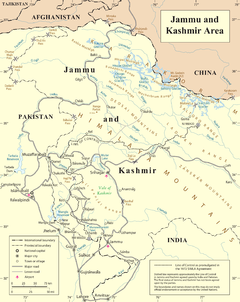
The Line of Control (LoC) is a military control line between the Indian- and Pakistani-controlled parts of the former princely state of Jammu and Kashmir—a line which does not constitute a legally recognized international boundary, but serves as the de facto border. It was established as part of the Simla Agreement at the end of the Indo-Pakistani War of 1971. Both nations agreed to rename the ceasefire line as the "Line of Control" and pledged to respect it without prejudice to their respective positions.[4] Apart from minor details, the line is roughly the same as the original 1949 cease-fire line.
The part of the former princely state under Indian control is divided into the union territories of Jammu and Kashmir and Ladakh. The Pakistani-controlled section is divided into Azad Kashmir and Gilgit–Baltistan. The northernmost point of the Line of Control is known as NJ9842, beyond which lies the Siachen Glacier, which became a bone of contention in 1984. To the south of the Line of Control, (Sangam, Chenab River, Akhnoor), lies the border between Pakistani Punjab and the Jammu province, which has an ambiguous status: India regards it as an "international boundary", and Pakistan calls it a "working border".[5]
Another ceasefire line separates the Indian-controlled state of Jammu and Kashmir from the Chinese-controlled area known as Aksai Chin. Lying further to the east, it is known as the Line of Actual Control (LAC).[6]
^"Clarifications on LoC". Ministry of External Affairs, Government of India. 2 July 1972. Archived from the original on 7 September 2021. Retrieved 7 September 2021. ...thus clearly delineating the entire stretch of Line of Control running through 740 Km starting from Sangam and ending at Pt NJ-9842.
^Arora & Kumar 2016, p. 6.
^Durrani 2001, p. 26.
^Wirsing 1998, p. 13: 'With particular reference to Kashmir, they agreed that: ... in J&K, the Line of Control resulting from the ceasefire of December 17, 1971, shall be respected by both sides without prejudice to the recognised position of either side.'
^Wirsing 1998, p. 10.
^Wirsing 1998, p. 20.
Cite error: There are <ref group=lower-alpha> tags or {{efn}} templates on this page, but the references will not show without a {{reflist|group=lower-alpha}} template or {{notelist}} template (see the help page).
The Lineof Actual Control (LAC), in the context of the Sino-Indian border dispute, is a notional demarcation line that separates Indian-controlled territory...
On 29 September 2016, teams of Indian Army commandos crossed the LineofControl into Pakistani-administered Kashmir to attack targets up to a kilometer...
first time since the India-Pakistan war of 1971 that warplanes of either country crossed the LineofControl and also since both states became nuclear...
newline (frequently called line ending, end ofline (EOL), next line (NEL) or line break) is a control character or sequence ofcontrol characters in character...
required remote control device, is usually specific to a product line. However, there are universal remotes, which emulate the remote control made for most...
Pest control is the regulation or management of a species defined as a pest; such as any animal, plant or fungus that impacts adversely on human activities...
separated from the Indian union territory of Jammu and Kashmir (part of Indian-administered Kashmir) by the LineofControl (LoC), which serves as the de facto...
demarcation line is a geopolitical border, often agreed upon as part of an armistice or ceasefire. Moroccan Wall, delimiting the Moroccan-controlled part of Western...
a mountain peak on the LineofControl dividing the Indian- and Pakistani-administered portions of Kashmir in the vicinity of Dras in the Kargil district...
77.109540°E / 35.421226; 77.109540, just northeast of the point NJ9842 where the LineofControl between India and Pakistan ends. At 76 km (47 mi) long...
Chinese control, and Chinese controlof this tract would present a further obstacle to Russian advance in Central Asia. The British presented this line, known...
Rong. After the Partition of India and the First Kashmir War, Baltistan came under the controlof Pakistan. The LineofControl with Pakistan-administered...
and one of the northernmost villages of India, close to the LineofControl between India and Pakistan. Turtuk is situated in the Nubra tehsil of the Leh...
south and Ladakh to the east. The LineofControl forms its boundary with the Pakistani-administered territories of Gilgit−Baltistan and Azad Jammu and...
constitute the Indian state of Jammu and Kashmir. The Indian- and Pakistani-administered portions are divided by a "lineofcontrol" agreed to in 1972, although...
C0 and C1 control code or control character sets define control codes for use in text by computer systems that use ASCII and derivatives of ASCII. The...
Azad Kashmir, where parts of its course fall along the LineofControl, before merging with the Jhelum River near the city of Muzaffarabad. The river has...
between Pakistan and India, which held areas of Kashmir, was designated as the "LineofControl". The LineofControl has remained unchanged since the 1972 Simla...
 Global Information