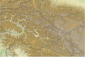
Ghent Kangri (or Mount Ghent, Ghaint I) is a high peak near the north end of the Saltoro Mountains, a subrange of the Karakoram range. It is located west of the Siachen Glacier near the Actual Ground Position Line between India and Pakistan.
Ghent Kangri was first climbed on 4 June 1961, by Wolfgang Axt, a member of an Austrian expedition led by Erich Waschak, via the West Ridge. He climbed solo above the high camp.
According to the Himalayan Index, there have been three subsequent ascents of the peak, in 1977, 1980, and 1984.
Indo-Pak mutually-agreed undisputed "International Border" (IB) in the black line, Indo-Pak "Line of Control" (LoC) in black dotted line in the north and west, Indo-Sino "Line of Actual" (LAC) in black dotted line in the east, Indo-Pak line across Siachen in north is "Actual Ground Position Line" (AGPL). The areas shown in green are the two Pakistani-controlled areas: Gilgit–Baltistan in the north and Azad Kashmir in the south. The area shown in orange is the Indian-controlled territories of Jammu and Kashmir, and Ladakh, and the diagonally-hatched area to the east is the Chinese-controlled area known as Aksai Chin. "Territories ceded by Pakistan to China claimed by India" in the north is Shaksgam (Trans-Karakoram Tract).United Nations map of Siachen Glacier showing "Point NJ980420" (Point NJ9842) as starting point of "Actual Ground Position Line" (AGPL), Goma military camp of Pakistan, Nubra River valley and Siachen glaciers held by India; Bilafond La and Sia La north of NJ9842 are also held by India. Masherbrum Range, Baltoro Glacier, Baltoro Glacier, Baltoro Muztagh and K2 are held by Pakistan.
GhentKangri (or Mount Ghent, Ghaint I) is a high peak near the north end of the Saltoro Mountains, a subrange of the Karakoram range. It is located west...
been ascended. The most recent peak to have its first ever ascent is Saser Kangri II East, in India, on 24 August 2011. The highest mountain outside of Asia...
states and territories by highest point The fight for Siachen "Saltoro Kangri - Peakbagger.com". www.peakbagger.com. "The HJ/45/15 FIRST ASCENT OF RIMO...
Sherpi Kangri is a mountain peak in the Karakoram Range. It lies six km south of GhentKangri (7,380 m) and ten km northwest of Saltoro Kangri (7,742...
La Yongma Ri, Gyong La, Gyong Kangri, Chumik Kangri, Bilafond La (pass) and nearby Bana Post, Saltoro Kangri, GhentKangri, and Sia La to the India–Pakistan–China...
La Yongma Ri, Gyong La, Gyong Kangri, Chumik Kangri, Bilafond La (pass) and nearby Bana Post, Saltoro Kangri, GhentKangri, and Sia La to the India–Pakistan–China...
and AGPL begins Gyong La Chumik Glacier Saltoro Mountains Saltoro KangriGhentKangri Bilafond La Sia La Indira Col Borders Actual Ground Position Line...
and AGPL begins Gyong La Chumik Glacier Saltoro Mountains Saltoro KangriGhentKangri Bilafond La Sia La Indira Col, AGPL ends at LAC Borders Actual Ground...
Pakistan. Sherpi Kangri, twin peaks 6 km south of GhentKangri (7,380 m) and 10 km northwest of Saltoro Kangri (7,742 m). Sherpi Kangri I is the higher...
Shingo La Spanggur Gap Zoji La Mountain peaks Bana Top Chumik KangriGhentKangri Gurung Hill India Saddle K12 Saltoro Kangri Sherpi Kangri Tiger Saddle...
Shingo La Spanggur Gap Zoji La Mountain peaks Bana Top Chumik KangriGhentKangri Gurung Hill India Saddle K12 Saltoro Kangri Sherpi Kangri Tiger Saddle...
(mountain) (peak) Bana Top (peak) Bilafond La Saltoro Valley GhentKangri Sia La Sia Kangri Indira Col Operation Vajrasakti / Qaidat Borders Actual Ground...
and AGPL begins Gyong La Chumik Glacier Saltoro Mountains Saltoro KangriGhentKangri Bilafond La Indira Col, AGPL ends at LAC Borders Actual Ground Position...
and AGPL begins Gyong La Chumik Glacier Saltoro Mountains Saltoro KangriGhentKangri Sia La Indira Col Borders Actual Ground Position Line (AGPL) India–Pakistan...
Gyong La Saltoro Mountains Saltoro KangriGhentKangri Bilafond La Sia La Indira Col, AGPL ends at LAC Chumik Kangri Borders Actual Ground Position Line...
January 2016. "Pharmacy College Saifai". Retrieved 24 January 2016. "Gurukula Kangri Vishwavidyalaya". Retrieved 23 January 2016. "Siddhartha Institute of Pharmacy"...
 Global Information