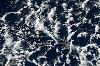
The 2012 Kermadec Islands eruption was a major undersea volcanic eruption that was produced by the previously little-known Havre Seamount near the L'Esperance and L'Havre Rocks[1] in the Kermadec Islands of New Zealand.[2][3] The large volume of low density pumice produced by the eruption accumulated as a large area of floating pumice, a pumice raft, that was originally covering a surface of 400 square kilometres (150 square miles), spread to a continuous float of between 19,000 and 26,000 km2 (7,500 and 10,000 sq mi)[4][5] and within three months dispersed to an area of more than twice the size of New Zealand.[6]
The thickness of the raft may initially have been as high as 3.5 metres (11 feet) and was reduced to around 50 cm (20 in) within a month.[7]
Three months after the eruption, the mass had dispersed into very dilute rafts and ribbons of floating pumice clasts. Most pumice clasts became waterlogged and sank to the sea floor, while some flocks have stranded in the Tonga islands, on the northern shores of New Zealand, and eventually on the eastern coast of Australia one year after the eruption.[7]
While the eruption is officially rated as a VEI 1 by the Smithsonian Institution, studies have found that approximately 1.5 cubic kilometres of material erupted, which correlates to a VEI 5 eruption.[8]
^Science Direct map of Kermadec Islands and Seamounts Archived 2 February 2013 at archive.today
^Klemetti, Erik (13 August 2012). "Havre Seamount: The Source of Kermadec Island Pumice Raft?". Wired. Retrieved 13 August 2012.
^Bryner, Jeanna (14 August 2012). "'Raft' in Pacific Found, NASA Says". Live Science. Retrieved 14 August 2012.
^Memmott, Mark (10 August 2012). "7,500 Square Miles of Pumice Floating in Pacific Is 'Weirdest Thing I've Seen'". NPR. Retrieved 13 August 2012.
^"Massive Rock Raft Found Floating off New Zealand". ABC News. Associated Press. 10 August 2012. Archived from the original on 12 August 2012. Retrieved 13 August 2012.
^Website of the expedition Mesh
^ abJutzeler, Martin; Marsh, Robert; Carey, Rebecca J.; White, James D. L.; Talling, Peter J.; Karlstrom, Leif (22 April 2014). "On the fate of pumice rafts formed during the 2012 Havre submarine eruption". Nature Communications. 5 (3660): 3660. Bibcode:2014NatCo...5.3660J. doi:10.1038/ncomms4660. PMC 3997806. PMID 24755668.
^Carey, Rebecca; Soule, S. Adam; Manga, Michael; White, James D. L.; McPhie, Jocelyn; Wysoczanski, Richard; Jutzeler, Martin; Tani, Kenichiro; Yoerger, Dana; Fornari, Daniel; Caratori-Tontini, Fabio (5 January 2018). "The largest deep-ocean silicic volcanic eruption of the past century". Science Advances. 4 (1): e1701121. Bibcode:2018SciA....4.1121C. doi:10.1126/sciadv.1701121. ISSN 2375-2548. PMC 5762192. PMID 29326974.
and 23 Related for: 2012 Kermadec Islands eruption information
The 2012KermadecIslandseruption was a major undersea volcanic eruption that was produced by the previously little-known Havre Seamount near the L'Esperance...
The KermadecIslands (/ˈkɜːrmədɛk/ KUR-mə-dek; Māori: Rangitāhua) are a subtropical island arc in the South Pacific Ocean 800–1,000 km (500–620 mi) northeast...
is a list of volcanic eruptions in the 21st century with a volcanic explosivity index (VEI) of 4 or higher, and smaller eruptions that resulted in fatalities...
Raoul Island (Sunday Island; Māori: Rangitāhua) is the largest and northernmost of the main KermadecIslands, 900 km (560 mi) south south-west of 'Ata...
This is a list of volcanoes that have had large explosive eruptions during the Holocene (since about 11,650 years Before Present), with a volcanic explosivity...
KermadecIslands group of New Zealand, in the south-west Pacific Ocean, on the Tonga-Kermadec Ridge. Its most recent eruption took place in July 2012...
Macauley Island is a volcanic island in New Zealand's KermadecIslands, approximately halfway between New Zealand's North Island and Tonga in the southwest...
Zealand's territorial waters. 2012KermadecIslandseruption – A major undersea volcanic eruption in the KermadecIslands of New Zealand Bollons Seamount...
Lloyd, Ian E.M. Smith, and Simon Nathan. () New Zealand's volcanoes: KermadecIslands Archived 2010-05-22 at the Wayback Machine. Volcanic Hazards Working...
activity in 1854, all eruptions have been in the Taupō Volcanic Zone or the Kermadec Arc. The KermadecIslands are an active volcanic island arc stretching north-northeast...
submarine volcano located among the South Kermadec Ridge Seamounts south of New Zealand's KermadecIslands. It consists of a volcanic cone that reaches...
(124 mi) southwest of the Samoan Islands. It is part of the Tonga-Kermadec volcanic arc, which stretches from the North Island of New Zealand to Samoa. The...
(1999) Southern Kermadec Submarine caldera arc volcanoes (South West Pacific): caldera formation by effusive and pyroclastic eruption, Marine Geology...
voyage they encountered massive pumice rafts caused by the 2012KermadecIslandseruption. This was so large that it was visible from trans-Pacific aircraft...
This article is a list of historical volcanic eruptions of approximately magnitude 6 or more on the Volcanic Explosivity Index (VEI) or equivalent sulfur...
deepest undersea eruption ever recorded occurred at the West Mata submarine volcano, a mile beneath the ocean, close to the Tonga-Kermadec Trench, within...
caldera was formed by a major eruption around 1,000 years BP, which left deposits up to 0.5 metres (1 ft 8 in) thick on islands over 40 kilometres (25 mi)...
KermadecIslands, about 1,000 km (620 mi) northeast of Auckland. Since 1937, the islands are uninhabited except for about six people at Raoul Island station...
century the island was settled by East Polynesian seafarers, either from the KermadecIslands north of mainland New Zealand, or from the North Island of New...
Geological Survey. March 29, 1954. Retrieved July 26, 2021. "M 7.5 – KermadecIslands region". United States Geological Survey. February 27, 1955. Retrieved...
Volcanic Zone and Kermadec Ridge. Mayor Island / Tūhua is a peralkaline shield volcano with a caldera partly formed in a large eruption some 7000 years...
 Global Information