This article needs additional citations for verification. Please help improve this article by adding citations to reliable sources. Unsourced material may be challenged and removed. Find sources: "Kermadec Islands" – news · newspapers · books · scholar · JSTOR(December 2008) (Learn how and when to remove this message)
Kermadec Islands
Rangitāhua
Location (in green rectangle) in the Pacific Ocean
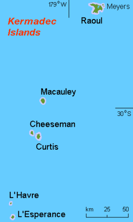
The Kermadec Islands (/ˈkɜːrmədɛk/KUR-mə-dek; Māori: Rangitāhua)[2] are a subtropical island arc in the South Pacific Ocean 800–1,000 km (500–620 mi) northeast of New Zealand's North Island, and a similar distance southwest of Tonga. The islands are part of New Zealand. They are 33.6 km2 (13.0 sq mi)[3] in total area and uninhabited, except for the permanently staffed Raoul Island Station, the northernmost outpost of New Zealand.
The islands are listed with the New Zealand outlying islands. The islands are an immediate part of New Zealand, but not part of any region or district, but instead an Area Outside Territorial Authority.
^"New Zealand Volcano Erupts". CBS News. 16 March 2006. Archived from the original on 18 June 2020. Retrieved 18 June 2020.
^"Kermadec Islands". Te Ara – the Encyclopedia of New Zealand. Retrieved 1 November 2022.
^"Data Table – Protected Areas – LINZ Data Service (recorded area 3359.9864 ha)". Land Information New Zealand. Retrieved 27 August 2019.
The KermadecIslands (/ˈkɜːrmədɛk/ KUR-mə-dek; Māori: Rangitāhua) are a subtropical island arc in the South Pacific Ocean 800–1,000 km (500–620 mi) northeast...
epicentres were located southeast of Raoul Island in the KermadecIslands, part of the New Zealand outlying islands. The main magnitude 8.1 earthquake was...
The 1908 KermadecIslands expedition was an research expedition undertaken between December 1907 and November 1908 to investigate the biodiversity of the...
outlying islands are: The islands are all uninhabited except the Chatham Islands. There is a staffed meteorological station on Raoul Island of the Kermadec Islands...
Lloyd, Ian E.M. Smith, and Simon Nathan. () New Zealand's volcanoes: KermadecIslands Archived 2010-05-22 at the Wayback Machine. Volcanic Hazards Working...
this tectonic plate is a small portion of the North Island of New Zealand and the KermadecIslands. It is separated from the Australian Plate by a long...
Island, Lord Howe Island, Norfolk Island, the Galápagos Islands, the KermadecIslands, the Pitcairn Islands and the Torres Strait Islands currently have...
"M 6.5 – KermadecIslands, New Zealand". earthquake.usgs.gov. United States Geological Survey. Retrieved 7 July 2021. "M 6.6 – KermadecIslands, New Zealand"...
Raoul Island (Sunday Island) is the largest and northernmost of the main KermadecIslands, 900 km (560 mi) south south-west of 'Ata Island of Tonga and...
Eastern Hemisphere; but Chatham Islands and KermadecIslands, as well as the self-governing states of the Cook Islands and Niue and the dependent territory...
Kermadec or de Kermadec may refer to: KermadecIslands, a subtropical island arc in the South Pacific Ocean northeast of New Zealand Kermadec Plate, a...
The 2012 KermadecIslands eruption was a major undersea volcanic eruption that was produced by the previously little-known Havre Seamount near the L'Esperance...
the coast of Greece Žut and other islands off the coast of Croatia KermadecIslands, part of New Zealand Korzhin Island in Lake Balkhash Klein Curaçao,...
Geological Survey. January 3, 2021. Retrieved January 3, 2021. "M 6.2 - KermadecIslands Region, New Zealand". United States Geological Survey. January 5, 2021...
National Earthquake Information Center (26 January 2023). "M 6.0 - KermadecIslands, New Zealand". United States Geological Survey. Archived from the original...
Polynesians once inhabited the Auckland Islands, the KermadecIslands, and Norfolk Island in pre-colonial times, but these islands were uninhabited by the time European...
from the original on May 2, 2024. Retrieved May 19, 2017. "M 7.0 - KermadecIslands, New Zealand". United States Geological Survey. May 20, 1968. Archived...
Geological Survey. March 29, 1954. Retrieved July 26, 2021. "M 7.5 – KermadecIslands region". United States Geological Survey. February 27, 1955. Retrieved...
the Aleutian Island chain of US territory the Gilbert Islands and the Phoenix Islands of Kiribati North Island and the KermadecIslands of New Zealand...
Polynesian settlements on Norfolk Island and the KermadecIslands (Rangitahua). By the time the Europeans first arrived, these islands were all uninhabited. Today...
This is a list of the bird species recorded on the KermadecIslands. The avifauna of the KermadecIslands include a total of 128 species. This list's taxonomic...
KermadecIslands, about 1,000 km (620 mi) northeast of Auckland. Since 1937, the islands are uninhabited except for about six people at Raoul Island station...
 Global Information