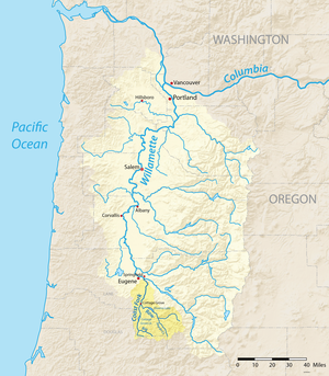
The Coast Fork Willamette River is one of two forks that unite to form the Willamette River in western Oregon in the United States. It is about 40 miles (64 km) long, draining an area of the mountains at the south end of the Willamette Valley south of Eugene.
^ abc"Coast Fork Willamette River". Geographic Names Information System (GNIS). United States Geological Survey. November 28, 1980. Retrieved August 4, 2010.
^Bright, William (2004). Native American Placenames of the United States. Norman, Oklahoma: University of Oklahoma Press. p. 567. ISBN 978-0-8061-3598-4.
^Source elevation derived from Google Earth search using GNIS source coordinates.
^United States Geological Survey (USGS). "United States Geological Survey Topographic Map: Harness Mountain, Oregon, Quadrant". TopoQuest. Retrieved August 3, 2010. The map includes river-mile markers from mouth to source.
^"Coast Fork Willamette". Willamette Riverkeeper. Archived from the original on August 7, 2010. Retrieved August 4, 2010.
^"Water-data report 2009: 14157500 Coast Fork Willamette River near Goshen, OR" (pdf). United States Geological Survey. Retrieved April 22, 2011.
^"Water-data report 2009: 14157500 Coast Fork Willamette River near Goshen, OR" (pdf). United States Geological Survey. Retrieved April 22, 2011.
and 20 Related for: Coast Fork Willamette River information
The CoastForkWillametteRiver is one of two forks that unite to form the WillametteRiver in western Oregon in the United States. It is about 40 miles...
The Middle ForkWillametteRiver is one of several forks that unite to form the WillametteRiver in the western part of the U.S. state of Oregon. It is...
Middle ForkWillametteRiver and CoastForkWillametteRiver near Springfield, the main stem meanders generally north from source to mouth. The river's two...
the WillametteRiver in the U.S. state of Oregon from the Columbia River upstream to the confluence of the Middle ForkWillametteRiver and CoastFork Willamette...
Cottage Grove Lake is a reservoir on the CoastForkWillametteRiver in Lane County, Oregon, United States. The lake is about 3 miles (4.8 km) long. Cottage...
deeply eroded by the CoastForkWillametteRiver and its tributaries. In the southern drainage, the tributaries of the North Umpqua River have cut into the...
Middle ForkWillametteRiver and CoastForkWillametteRiver, OR/WA) to mouth (Columbia River, OR) Dams are listed in order from headwaters of each fork (North...
Gettings Creek is a tributary of the CoastForkWillametteRiver in Lane County, in the U.S. state of Oregon. Flowing generally west from near Prune Hill...
Engineers in the WillametteRiver's basin. Set at the south end of the Willamette Valley and criss-crossed by the CoastForkWillametteRiver and its tributary...
southeastern Willamette Valley along the McKenzie, Mohawk, and CoastForkWillametterivers The phonology of the Santiam dialect, as described by Jacobs...
Oregon, United States. It is 78 feet (24 m) long and spans the CoastForkWillametteRiver. It was built in 1925 to carry rail traffic hauling logs from...
Chetco River Chewaucan River Clackamas River Clatskanie River Clear Fork Clearwater RiverCoastForkWillametteRiver Collawash River Columbia River Columbia...
Grove Lake – CoastForkWillametteRiver Cougar Reservoir and Cougar Dam – South Fork McKenzie River Crane Prairie Reservoir – Deschutes River Detroit Lake...
Long Tom River McKenzie River Mohawk River Cougar Dam and Cougar Reservoir CoastForkWillametteRiver Big River Middle ForkWillametteRiver Lookout Point...
Bull Run Lake and Mount Hood Cleawox Lake on the coast Cougar Reservoir on the South Fork McKenzie River Crater Lake Cullaby Lake in Clatsop County Cultus...
10 feet (3.0 m) wide and 14 feet (4.3 m) high. It spans the CoastForkWillametteRiver alongside Main Street, carrying only bicycle and pedestrian traffic...
post office. Little River joins Big River a few miles downstream to form the CoastForkWillametteRiver. On older maps, Little River appears as a tributary...
 Global Information