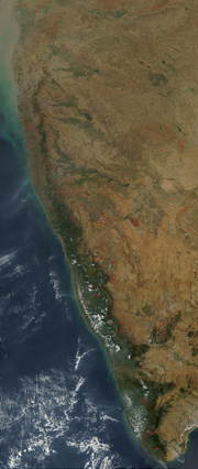
Satellite imagery showing the Western Ghats running parallel to the west coast of India
Country
India
Region
Western and Southern India
States
Gujarat, Maharashtra, Goa, Karnataka, Kerala and Tamil Nadu
Biome
Tropical rainforests and Marsh
Geology
Age of rock
Cenozoic
Type of rock
Basalt, Laterite and Limestone
UNESCO World Heritage Site
Criteria
Natural: ix, x
Reference
1342
Inscription
2012 (36th Session)
Area
795,315 ha
The Western Ghats, also known as the Sahyadris, is a mountain range that stretches 1,600 km (990 mi) along the western coast of the Indian peninsula. Covering an area of 160,000 km2 (62,000 sq mi), it traverses the states of Gujarat, Maharashtra, Goa, Karnataka, Kerala and Tamil Nadu. The mountains form an almost continuous chain of mountains along the western edge of the Deccan Plateau from the Tapti river to the southern tip of the Indian peninsula at Kanniyakumari. The Western Ghats meets with the Eastern Ghats at Nilgiris before continuing south.
Geologic evidence indicates that the mountains were formed during the break-up of the supercontinent of Gondwana. The mountains came along the west coast of India somewhere in the late Jurassic and early Cretaceous period when India separated from the African continent. The mountains can be roughly divided into three parts, northern section with elevation ranging from 900–1,500 m (3,000–4,900 ft), middle section starting from south of Goa with a lower elevation of less than 900 m (3,000 ft) and the southern section where the altitude rises again. The Western Ghats have several peaks that rise above 2,000 m (6,600 ft), with Anamudi (2,695 m (8,842 ft)) being the highest peak. The average elevation is around 1,200 m (3,900 ft).
The Western Ghats form one of the major watersheds of India, feeding many perennial river systems that drain almost 40% of the land area of the country. Because of the higher elevation of the Deccan plateau on the west, most rivers flow from eastwards towards the Bay of Bengal, resulting in chiselled eastern slopes and steeper western slopes, facing the Arabian sea. The Western Ghats plays an important role in determining the climate and seasons in India. It blocks the rain bearing monsoon winds flowing eastward from the Arabian Sea, resulting in rainfall along the western coast. By the time the air rises above the mountains, it becomes dry, resulting in forming a rain shadow region with very less rainfall on the leeward side towards the interior of the Deccan plateau.
The Western Ghats region is a biodiversity hotspot. It contains of a large number of different species of flora and fauna, significant of which are endemic to this region. At least 325 globally threatened species occur in the Western Ghats. The region was declared as a UNESCO World Heritage Site in 2012.
Following is a list of peaks in the WesternGhats: "Eravikulam National Park, Munnar, Kerala, India, the home of Nilgiri Tahr". Eravikulam.org. Archived...
The Eastern Ghats are a discontinuous range of mountains along India's eastern coast. The Eastern Ghats pass through the states of Odisha and Andhra Pradesh...
Charmadi Ghat of Karnataka is also notable. In many cases, the term is used to refer to a mountain range itself, as in the WesternGhats and Eastern Ghats. 'Ghattam'...
Ghats in Varanasi are riverfront steps leading to the banks of the Ganges river. The city has 84 ghats. Most of the ghats are bathing and puja ceremonial...
highest number of Ghat Roads.[better source needed] The WesternGhats are bounded by Tapti River to the north, and the Eastern Ghats are bounded by Mahanadi...
Eastern Ghats and Adjacent Deccan Region". In Pullaiah, T.; Krishnamurthy, K.V.; Bahadur, Bir (eds.). Ethnobotany of India. Volume 1, Eastern Ghats and Deccan...
has three crucial biogeographic zones, namely WesternGhats, Deccan Plateau, and the West coast. The Ghats nurture endemic species, Deccan Plateau provides...
and had recommended the establishment of the WesternGhats Ecology Authority for management of the Ghats. The 10-member Working Group, headed by Planning...
along the WesternGhats (Konkan and Goa) with precipitation on coastal areas, west of the WesternGhats. The eastern areas of the WesternGhats do not receive...
The Western Coastal Plains is a strip of coastal plain 50 kilometres (31 mi) in width between the west coast of India and the WesternGhats hills, which...
the state of Karnataka, India. Malenadu covers the western and eastern slopes of the WesternGhats mountain range and is roughly 100 kilometers in width...
portion of Deccan Plateau which links the WesternGhats with the Eastern Ghats. It is set high in the WesternGhats with altitudes ranging from 700 to 2,100...
Konkan region, geographically separated from the Deccan highlands by the WesternGhats. It is bound by the Indian states of Maharashtra to the north, and Karnataka...
The South WesternGhats moist deciduous forests is an ecoregion in the WesternGhats of southern India with tropical and subtropical moist broadleaf forests...
plateau is surrounded by the western and the eastern ghats. These ghats meet each other at the Nilgiri hills. The westernghats includes the Sahyadri, Nilgiris...
peninsula, Tamil Nadu is straddled by the WesternGhats and Deccan Plateau in the west, the Eastern Ghats in the north, the Eastern Coastal Plains lining...
Thal Ghat (also called as Thul Ghat or Kasara Ghat) is a ghat section (mountain incline or slope) in the WesternGhats near the town of Kasara in Maharashtra...
Thamarassery Churam is a mountain pass in Kerala, India across the WesternGhats. "Churam" is the Malayalam word for 'mountain pass'. It is a part of...
portion of the WesternGhats contains the highest peaks in the range, notably Anamudi in Kerala, at 2695 meters elevation. The Ghats intercept the moisture-laden...
India's land) is situated between the Lakshadweep Sea to the west and the WesternGhats to the east. Kerala's coast runs some 590 km in length, while the state...
The WesternGhats in India are home to several species of caecilians (Gymnophiona). Caecilians are legless, burrowing amphibians which mostly live in...
portion of the WesternGhats contains the highest peaks in the range, notably Anai Mudi in Kerala, at 2695 meters elevation. The Ghats intercept the moisture-laden...
The hills are located at the north-west of the WesternGhats and the westernmost edge of the Eastern Ghats. Thus this area supports a diverse flora and...
transition to the South WesternGhats moist deciduous forests further the south. To the east, in the dry rain shadow of the Ghats, are the Deccan thorn...
India. The WesternGhats, along the western coast, mark another boundary of the plateau. The narrow strip of verdant land between the WesternGhats and the...
important. The state is situated between Arabian Sea to the west and WesternGhats mountain ranges to the east. The state's coastline extends for 595 kilometres...
situated near the center of the South Indian Peninsula, surrounded by WesternGhats. Agriculture and textile industries contribute majorly to the economy...
 Global Information