Type of satellite designed to record the state of the Earth's atmosphere
Not to be confused with Atmospheric satellite.
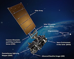
GOES-16, a United States weather satellite of the meteorological-satellite service
A weather satellite or meteorological satellite is a type of Earth observation satellite that is primarily used to monitor the weather and climate of the Earth. Satellites can be polar orbiting (covering the entire Earth asynchronously), or geostationary (hovering over the same spot on the equator).[1]
While primarily used to detect the development and movement of storm systems and other cloud patterns, meteorological satellites can also detect other phenomena such as city lights, fires, effects of pollution, auroras, sand and dust storms, snow cover, ice mapping, boundaries of ocean currents, and energy flows. Other types of environmental information are collected using weather satellites. Weather satellite images helped in monitoring the volcanic ash cloud from Mount St. Helens and activity from other volcanoes such as Mount Etna.[2] Smoke from fires in the western United States such as Colorado and Utah have also been monitored.
El Niño and its effects on weather are monitored daily from satellite images. The Antarctic ozone hole is mapped from weather satellite data. Collectively, weather satellites flown by the U.S., Europe, India, China, Russia, and Japan provide nearly continuous observations for a global weather watch.
^NESDIS. Satellites.[link not working] Retrieved on July 4, 2008. Archived July 4, 2008, at the Wayback Machine
^NOAA. NOAA Satellites, Scientists Monitor Mt. St. Helens for Possible Eruption. Archived September 10, 2012, at archive.today Retrieved on July 4, 2008.
A weathersatellite or meteorological satellite is a type of Earth observation satellite that is primarily used to monitor the weather and climate of the...
part of global commerce. Weathersatellite systems provide information about terrestrial weather. The signals from satellites of a global positioning system...
uses geosynchronous equatorial satellites that, since the launch of SMS-1 in 1974, have been a basic element of U.S. weather monitoring and forecasting....
A satellite or artificial satellite is an object in space, typically a spacecraft, placed into orbit around a celestial body. Satellites have a variety...
NASA's Television Infrared Observation Satellite (TIROS) program, sent back the first television footage of weather patterns to be taken from space. In 2008...
Satellite images (also Earth observation imagery, spaceborne photography, or simply satellite photo) are images of Earth collected by imaging satellites...
satellites are located. Weathersatellites are also placed in this orbit for real-time monitoring and data collection, and navigation satellites to provide a known...
Air Force Weather Agency. New generations of satellites are developed to succeed the current polar orbiting and geosynchronous satellites, the Joint...
This is a list of weather records, a list of the most extreme occurrences of weather phenomena for various categories. Many weather records are measured...
A communications satellite is an artificial satellite that relays and amplifies radio telecommunication signals via a transponder; it creates a communication...
with meteorology and weather forecasting. Unbeknownst to many, the U.S. military services were also starting up a weathersatellite program. This program...
from weathersatellites are used in areas where traditional data sources are not available. Compared with similar data from radiosondes, the satellite data...
20th century developed new remote sensing tools, such as weather radars, weathersatellites and wind profilers, which provide better sampling both regionally...
Weather modification is the act of intentionally manipulating or altering the weather. The most common form of weather modification is cloud seeding, which...
programs. Weather portal Weather media in the United States The Weather Network – A Canadian Category A cable and satellite channel devoted to weather forecasts...
A satellite tornado is a tornado that revolves around a larger, primary tornado and interacts with the same mesocyclone. Satellite tornadoes occur apart...
systems, ULA has launched payloads including weather, telecommunications, and national security satellites, scientific probes and orbiters. ULA also launches...
The Synchronous Meteorological Satellite (SMS) program, was a program where NASA developed two weathersatellites; which were placed into geosynchronous...
different satellites to study Earth, such as Television Infrared Observation Satellite (TIROS) in 1960, which was the first weathersatellite. NASA and...
auction off all of the weathersatellites, to repurchase data from private buyers, outsourcing weather observation stations, NOAA Weather Radio and computerized...
Launch Alliance Marks 80th Successful Launch by Delivering Air Force's WeatherSatellite to Orbit". United Launch Alliance. 3 April 2014. Archived from the...
activity. At 00:19 UTC on 13 May, the GOES-16 satellite, the primary operational geostationary weathersatellite in the GOES East position, providing a view...
ground. Some satellites in polar orbits lost control for several hours. GOES weathersatellite communications were interrupted, causing weather images to...
Television InfraRed Observation Satellite (TIROS) is a series of early weathersatellites launched by the United States, beginning with TIROS-1 in 1960...
data from airport weather stations, on-ground radar stations, weathersatellites, remote sensing satellites, METAR, and automated weather stations. The company...
 Global Information