The Tygart Valley River in Elkins in 2006Tygart River Lake and Dam near Grafton, West Virginia. View is upriver to the south.
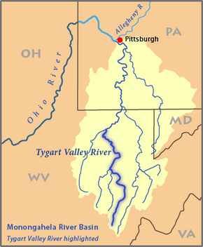
The Tygart Valley River — also known as the Tygart River — is a principal tributary of the Monongahela River, approximately 135 miles (217 km) long,[3] in east-central West Virginia in the United States. Via the Monongahela and Ohio rivers, it is part of the watershed of the Mississippi River, draining an area of 1,329 square miles (3,440 km2) in the Allegheny Mountains and the unglaciated portion of the Allegheny Plateau.
^ abcGeographic Names Information System. "Geographic Names Information System entry for Tygart Valley River (Feature ID #1553309)". Retrieved 2007-03-12.
^Google Earth elevation for GNIS source coordinates. Retrieved on March 12, 2007.
^ abU.S. Geological Survey. National Hydrography Dataset high-resolution flowline data. The National Map, accessed August 15, 2011
^Rice, Donald L. (2006). "Tygart Valley River". In Ken Sullivan (ed.). The West Virginia Encyclopedia. Charleston, W.Va.: West Virginia Humanities Council. p. 721. ISBN 0-9778498-0-5.
^United States Environmental Protection Agency. "Watershed Report: Tygart Valley River". watersgeo.epa.gov. Archived from the original on 2021-07-03. Retrieved 2021-07-03.
and 14 Related for: Tygart Valley River information
The TygartValleyRiver — also known as the TygartRiver — is a principal tributary of the Monongahela River, approximately 135 miles (217 km) long, in...
Monongahela is formed by the confluence of the West Fork River and its "east fork"—the TygartValleyRiver—at Fairmont in north central West Virginia. From there...
Buckhannon River is a 45.4-mile-long (73.1 km) tributary of the TygartValleyRiver in north-central West Virginia, USA. Via the TygartValley, Monongahela...
rafting. Ohio River Monongahela RiverTygartValleyRiver Files Creek Leading Creek Middle Fork River Buckhannon River Left Fork Buckhannon River Right Fork...
TygartValley Homesteads Historic District is a national historic district located near Dailey, Randolph County, West Virginia. It encompasses 337 contributing...
River, Cheat River, TygartValleyRiver, or the West Fork of the Monongahela River. Along with the rest of western Virginia, the Cheat RiverValley became...
Valley Falls State Park is a 1,145 acre (4.63 km²) day use facility sited along both banks of the TygartValleyRiver. The park is located about 7 miles...
Middle Fork River is a 35.4-mile-long (57.0 km) tributary of the TygartValleyRiver in north-central West Virginia, USA. Via the TygartValley, Monongahela...
Mountain, while the remaining three were at Camp Elkwater near the TygartValleyRiver, where Reynolds established his headquarters. Gen. Robert E. Lee...
(Virginia) in the state of Virginia Rich Mountain (TygartValleyRiver) bordering the TygartValleyRiver in western Randolph County, West Virginia Rich Mountain...
route left Elkins and the TygartValleyRiver drainage by way of a tunnel under Cheat Mountain, followed the Shavers Fork river upstream and then the West...
 Global Information