West Fork, Coal Run, Buffalo Creek, Hawkinberry Run, Paw Paw Creek, Pharoah Run, Parker Run, Indian Creek, Birchfield Run, Meadow Run, Broad Run, Dents Run, Scotts Run, Courtney Run, Robinson Run, Crooked Run, Dunkard Creek, Whiteley Creek, Little Whiteley Creek, Pegs Run, Muddy Creek, Noel Run, Pumpkin Run, Rush Run, Tenmile Creek, Fishpot Run, Barneys Run, Twomile Run, Lilly Run, Pike Run, Wood Run, Hooders Run, Maple Creek, Pigeon Creek, Dry Run, Mingo Creek, Huston Run, Lobbs Run, Peters Creek, Thompson Run, Homestead Run, West Run, Streets Run, Becks Run
• right
Tygart River, Prickett Creek, Little Creek, Whiteday Creek, Joes Run, Toms Run, Booths Run, Cobun Creek, Deckers Creek, West Run, Laurel Run, Camp Run, Cheat River, Georges Creek, Jacobs Creek, Cats Run, Browns Run, Middle Run, Antram Run, Wallace Run, Hereford Hollow, Bates Run, Meadow Run, Kelley Run, Rush Run, Dunlap Creek, Redstone Creek, Lamb Lick Run, Downers Run, Speers Run, Turkey Hollow, Beckers Run, Sunfish Run, Bunola Run, Kelly Run, Mill Run, Smiths Run, Fallen Timber Run, Wylie Run, Youghiogheny River, Crooked Run, Turtle Creek, Ninemile Run
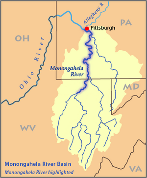
The Monongahela River (/məˌnɒŋɡəˈhiːlə/mə-NONG-gə-HEE-lə, /-ˈheɪ-/-HAY-),[10] sometimes referred to locally as the Mon (/mɒn/), is a 130-mile-long (210 km)[6] river on the Allegheny Plateau in north-central West Virginia and Southwestern Pennsylvania. The river flows from the confluence of its west and east forks in north-central West Virginia northeasterly into southwestern Pennsylvania, then northerly to Pittsburgh and its confluence with the Allegheny River to form the Ohio River. The river includes a series of locks and dams that makes it navigable.
^Geographic Names Information System. "Geographic Names Information System entry for Tygart Valley River (Feature ID #1553309)". Retrieved March 12, 2007.
^Google Earth elevation for GNIS source coordinates. Retrieved on March 12, 2007.
^ abGeographic Names Information System. "Geographic Names Information System entry for West Fork River (Feature ID #1548931)". Retrieved March 12, 2007.
^Geographic Names Information System. "Geographic Names Information System entry for Straight Fork (headwaters tributary of West Fork River) (Feature ID #1547564)". Retrieved March 12, 2007.
^ abcGeographic Names Information System. "Geographic Names Information System entry for Monongahela River (Feature ID #1209053)". Retrieved March 12, 2007.
^ abU.S. Geological Survey. National Hydrography Dataset high-resolution flowline data. The National Map, accessed August 15, 2011
^Gillespie, William H. (2006). "Monongahela River". In Ken Sullivan (ed.). The West Virginia Encyclopedia. Charleston, W.Va.: West Virginia Humanities Council. p. 492. ISBN 0-9778498-0-5.
^United States Geological Survey;
USGS 03085000 Monongahela River at Braddock, PA; retrieved September 29, 2010.
^United States Geological Survey; USGS 03072655 Monongahela River near Masontown, PA; retrieved September 29, 2010.
^There are several ways to pronounce this word that are acceptable. From "Geographical Names" of Merriam-Webster's Collegiate Dictionary, Eleventh Edition (2009): /məˌnɒnɡəˈhiːlə/, /məˌnɒɡəˈhiːlə/ or /məˌnɒŋɡəˈheɪlə/.
The MonongahelaRiver (/məˌnɒŋɡəˈhiːlə/ mə-NONG-gə-HEE-lə, /-ˈheɪ-/ -HAY-), sometimes referred to locally as the Mon (/mɒn/), is a 130-mile-long (210 km)...
The Battle of the Monongahela (also known as the Battle of Braddock's Field and the Battle of the Wilderness) took place on July 9, 1755, at the beginning...
Crossings of the Ohio River in Pennsylvania Crossings of the Allegheny River in Pennsylvania Crossings of the MonongahelaRiver in Pennsylvania Wikimedia...
Cemetery, a historic cemetery in Monongahela City, Pennsylvania Monongahela City Bridge, spans the MonongahelaRiverMonongahela National Forest, a national...
The Cheat River is a 78.3-mile-long (126.0 km) tributary of the MonongahelaRiver in eastern West Virginia and southwestern Pennsylvania in the United...
Youghiogheny River (/jɒkəˈɡeɪni/ yok-ə-GAY-nee), or the Yough (/ˈjɒk/ YOK) for short, is a 134-mile-long (216 km) tributary of the MonongahelaRiver in West...
The Monongahela National Forest is a national forest located in the Allegheny Mountains of eastern West Virginia, USA. It protects over 921,000 acres...
River – Pittsburgh, Pennsylvania MonongahelaRiver – Pittsburgh Beaver River – Rochester, Pennsylvania Little Muskingum River - Ohio Muskingum River –...
The Tygart Valley River — also known as the Tygart River — is a principal tributary of the MonongahelaRiver, approximately 135 miles (217 km) long, in...
confluence of the Allegheny River and the MonongahelaRiver whose joining forms the Ohio River. The triangle is bounded by the two rivers. The area features offices...
bank of the MonongahelaRiver, at the foot of the Smithfield Street Bridge. The P&LE followed the left downstream bank of the MonongahelaRiver past the...
Pennsylvania to join the MonongahelaRiver at the Forks of the Ohio at Point State Park in Downtown Pittsburgh, Pennsylvania. The Allegheny River is, by volume,...
preemptive strike, an ambush of Braddock's army as he crossed the MonongahelaRiver. The Indian allies were initially reluctant to attack such a large...
Pennsylvania at the confluence of the Allegheny River and the MonongahelaRiver, which combine to form the Ohio River. It developed as a vital link of the Atlantic...
crossings of the Ohio River from the mouth at the Mississippi River at Cairo, Illinois to the confluence of the Allegheny and MonongahelaRivers at Pittsburgh...
Bridge, crossing the Lemon Fair River near East Shoreham, Vermont Fairmont Railroad Bridge, crossing the MonongahelaRiver near Fairmont, West Virginia First...
Mary Butler in 1939 for the MonongahelaRiver, whose valley contains the majority of this culture's sites. The Monongahela practiced maize agriculture...
Ramcat Run Casselman River Laurel Hill Creek Coxes Creek Hen Run Tub Run Hall Run Braddocks Run Reason Run Lewis Run (MonongahelaRiver tributary) Peters...
of the MonongahelaRiver on the South Side of Pittsburgh and along the Ohio River at Aliquippa. The Hot Metal Bridge across the MonongahelaRiver was built...
with a dispute over control of the confluence of the Allegheny River and MonongahelaRiver called the Forks of the Ohio, and the site of the French Fort...
established by the French in 1754, at the confluence of the Allegheny and Monongahelarivers. It was later taken over by the British, and later the Americans,...
occupied most of the flat lands adjacent to the South Side of the MonongahelaRiver, leaving only the steep, surrounding hillsides of Mt. Washington,...
crossings of the MonongahelaRiver starting from Pittsburgh, Pennsylvania, where the river helps to form the headwaters of the Ohio River, and ending in...
has also been found recently in Ohio. The common name refers to the MonongahelaRiver, with the first specimens being collected from Edgewood Park, Allegheny...
Branch Potomac River Evitts Creek Wills Creek Jennings Run Georges Creek Laurel Run Savage River Mississippi River Ohio RiverMonongahelaRiver (PA) Youghiogheny...
 Global Information