 Global Information
Cheat River information
| Cheat River | |
|---|---|
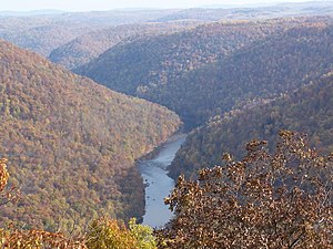 The Cheat River Gorge, as viewed from Cooper's Rock Overlook | |
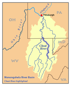 Map of the Monongahela River basin, with the Cheat River highlighted. | |
| Location | |
| Country | United States |
| State | Pennsylvania, West Virginia |
| County | Fayette PA, Monongalia WV, Preston WV, Tucker WV |
| Physical characteristics | |
| Source | Shavers Fork |
| • location | West Virginia |
| • coordinates | 38°23′50″N 79°59′09″W / 38.39722°N 79.98583°W |
| • elevation | 4,620 ft (1,410 m) |
| 2nd source | Black Fork |
| • location | Hendricks, West Virginia |
| • coordinates | 39°04′20″N 79°37′45″W / 39.07222°N 79.62917°W |
| • elevation | 1,700 ft (520 m) |
| Source confluence | |
| • location | Parsons, WV |
| • coordinates | 39°07′01″N 79°40′51″W / 39.11694°N 79.68083°W |
| • elevation | 1,621 ft (494 m) |
| Mouth | Monongahela River[1] |
• location | Point Marion, PA |
• coordinates | 39°44′34″N 79°54′08″W / 39.74278°N 79.90222°W |
• elevation | 760 ft (230 m) |
| Length | 78 mi (126 km)[2] |
| Basin size | 1,423 sq mi (3,690 km2)[2] |
| Discharge | |
| • location | Rowlesburg, WV[3] |
| • average | 3,880 cu ft/s (110 m3/s) |
| • minimum | 908 cu ft/s (25.7 m3/s) |
| • maximum | 53,400 cu ft/s (1,510 m3/s) |
| Discharge | |
| • location | Parsons, WV[4] |
| • average | 3,700 cu ft/s (100 m3/s) |
| Basin features | |
| Progression | generally north |
| River system | Monongahela River |
| Tributaries | |
| • left | Brannons Run, Clover Run, Upper Jonathan Run, Jonathan Run, Bull Run, Bearwallow Run, Licking Creek, Louse Camp Run, Ford Run, Muddy Run, Big Run, Keyser Run, Scott Run, Little Buffalo Creek, Buffalo Creek, Tray Run, Buckhorn Run, Pringle Run, Lick Run, Heather Run, Greens Run, Laurel Run, Hackelberry Run, Gum Run, Bull Run, Bee Run, Buzzard Run, Maple Run, Crammeys Run |
| • right | Devils Dump Run, Wolf Run, Mill Run, Dry Run, Horseshoe Run, Dry Run, Minear Run, Clay Lick, Laurel Run, Tobes Run, Stave Run, Panther Run, Glades Run, Wolf Creek, Madison Run, Saltlick Creek, Hickory Bearpen Run, Bearwallow Run, Stamping Ground Run, Joes Run, Buffalo Run, Ashpole Run, Elsey Run, Daugherty Run, Roaring Creek, Muddy Creek, Beech Run, Conner Run, Gibson Run, Big Sandy Creek, Big Run, Christopher Run, Scott Run, Quarry Run, Kelley Run, Coles Run, Morgan Run, Rubles Run, Grassy Run |
The Cheat River is a 78.3-mile-long (126.0 km)[5] tributary of the Monongahela River in eastern West Virginia and southwestern Pennsylvania in the United States. Via the Ohio River, the Cheat and Monongahela are part of the Mississippi River watershed. Owing to the ruggedness of the surrounding Allegheny Mountains, the Cheat remains largely remote with few settlements or developments along its banks. Its headwaters are in the Cheat-Potomac Ranger District of the Monongahela National Forest.
- ^ U.S. Geological Survey Geographic Names Information System: Cheat River
- ^ a b Kosky, James P.E.; Lessons Learned: Cheat River and Tygart River Flood Warning Systems; retrieved from stormwatch.com March 13, 2007.
- ^ United States Geological Survey; USGS 03069870 CHEAT RIVER AT HWY 50 NEAR ROWLESBURG, WV; retrieved March 13, 2007.
- ^ United States Geological Survey; USGS 03069500 CHEAT RIVER NEAR PARSONS, WV; retrieved March 13, 2007.
- ^ U.S. Geological Survey. National Hydrography Dataset high-resolution flowline data. The National Map Archived 2012-03-29 at the Wayback Machine, accessed August 15, 2011