Global Information Lookup Global Information

Tiltmeter information


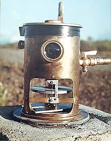
A tiltmeter on Mauna Loa, used to predict eruptions by measuring very small changes in the profile of the mountain.

A tiltmeter is a sensitive inclinometer designed to measure very small changes from the vertical level, either on the ground or in structures.[1] Tiltmeters are used extensively for monitoring volcanoes, the response of dams to filling, the small movements of potential landslides, the orientation and volume of hydraulic fractures, and the response of structures to various influences such as loading and foundation settlement. Tiltmeters may be purely mechanical or incorporate vibrating-wire or electrolytic sensors for electronic measurement. A sensitive instrument can detect changes of as little as one arc second.

Tiltmeters have a long history, somewhat parallel to the history of the seismometer. The very first tiltmeter was a long-length stationary pendulum. These were used in the very first large concrete dams, and are still in use today, augmented with newer technology such as laser reflectors. Although they had been used for other applications such as volcano monitoring, they have distinct disadvantages, such as their huge length and sensitivity to air currents. Even in dams, they are slowly being replaced by the modern electronic tiltmeter.

Volcano and Earth movement monitoring then used the water-tube, long baseline tiltmeter.[2] In 1919, the renowned physicist, Albert A. Michelson, noted that the most favorable arrangement to obtain high sensitivity and immunity from temperature perturbations is to use the equipotential surface defined by water in a buried half-filled water pipe.[3] This was a simple arrangement of two water pots, connected by a long water-filled tube. Any change in tilt would be registered by a difference in fill-mark of one pot compared to the other. Although extensively used throughout the world for Earth-science research, they have proven to be quite difficult to operate. For example, due to their high sensitivity to temperature differentials, these always have to be read in the middle of the night.

The modern electronic tiltmeter, which is slowly replacing all other forms of tiltmeter, uses a simple bubble level principle, as used in the common carpenter level.[4] As shown in the figure, an arrangement of electrodes senses the exact position of the bubble in the electrolytic solution, to a high degree of precision. Any small changes in the level are recorded using a standard datalogger. This arrangement is quite insensitive to temperature, and can be fully compensated, using built-in thermal electronics.[5]

A newer technology using microelectromechanical systems (MEMS) sensors enables tilt angle measuring tasks to be performed conveniently in both single and dual axis mode. Ultra-high precision 2-axis MEMS driven digital inclinometer/ tiltmeter instruments are available for speedy angle measurement applications and surface profiling requiring very high resolution and accuracy of one arc second. The 2-axis MEMS driven inclinometers/ tiltmeters can be digitally compensated and precisely calibrated for non-linearity and operating temperature variation, resulting in higher angular accuracy and stability performance over wider angular measurement range and broader operating temperature range. Further, digital display of readings can effectively prevent parallax error as experienced when viewing traditional ‘bubble’ vials located at a distance.

The most dramatic application of tiltmeters is in the area of volcanic eruption prediction.[6] As shown in this figure from the USGS, the main volcano in Hawaii (Kilauea) has a pattern of filling the main chamber with magma, and then discharging to a side vent. The graph shows this pattern of swelling of the main chamber (recorded by the tiltmeter), draining of that chamber, and then an eruption of the adjoining vent. Each number at the peak of tilt, on the graph, is a recorded eruption.

  1. ^ John Dunnicliff Geotechnical instrumentation for monitoring field performance Wiley-IEEE, 1993 ISBN 0-471-00546-0, pp. 216–219
  2. ^ "How We Monitor Volcanoes". Volcanoes.usgs.gov. 2008-08-13. Retrieved 2014-05-30.
  3. ^ "What is a Tiltmeter?". www.wisegeek.com. 2014-05-30. Retrieved 2014-05-30.
  4. ^ "Tiltmeter Basics". www.geomechanics.com. Archived from the original on August 25, 2006.
  5. ^ "Movement on the Surface Provides Information About the Subsurface | U.S. Geological Survey".
  6. ^ "How We Monitor Volcanoes". Volcanoes.usgs.gov. 2008-08-13. Retrieved 2014-02-05.

and 26 Related for: Tiltmeter information

Request time (Page generated in 0.5704 seconds.)

Tiltmeter

Last Update:

A tiltmeter is a sensitive inclinometer designed to measure very small changes from the vertical level, either on the ground or in structures. Tiltmeters...

Word Count : 704

Punk rock in Australia

Last Update:

Jebediah, Bodyjar, 28 Days, Dreamkillers, Four Zero One Four, Align, Tiltmeter and Guttersnipes. Punk revival scenes began in various cities around Australia...

Word Count : 2783

Tsunami warning system

Last Update:

accelerometer, GPS antenna. In four cases, it was installed a short-base tiltmeter (pendulum). Some stations were ubicated underground at a depth of 3–4...

Word Count : 2545

Inclinometer

Last Update:

facilitate aiming of shells over long distances. Permanently-installed tiltmeters are emplaced at major earthworks such as dams to monitor the long-term...

Word Count : 2100

Mount Bromo

Last Update:

Mitigation (CVGHM) reported on 13 January 2011, that deformation using tiltmeter measurements indicated an inflation at rate of 5 micro radians between...

Word Count : 1973

Subsidence

Last Update:

System (GNSS) Interferometric Synthetic Apertura Radar (InSAR) LiDAR Tiltmeters. Tomás et al. conducted a comparative analysis of various land subsidence...

Word Count : 4770

Earthquake

Last Update:

throughout the volcanoes. These swarms can be recorded by seismometers and tiltmeters (a device that measures ground slope) and used as sensors to predict imminent...

Word Count : 8863

Inverted pendulum

Last Update:

broomstick on the end of one's finger. A second type of inverted pendulum is a tiltmeter for tall structures, which consists of a wire anchored to the bottom of...

Word Count : 4447

Phobos 2

Last Update:

susceptibility sensor gravimeter temperature sensors BISIN conductometer / tiltmeter mechanical sensors (penetrometer, UIU accelerometer, sensors on hopping...

Word Count : 773

Vertical deflection

Last Update:

in the subsurface. More recently, a combination of digital camera and tiltmeter have also been used, see zenith camera. Vertical deflections are principally...

Word Count : 1418

Mauna Loa

Last Update:

its local seismic network but also of a large number of GPS stations, tiltmeters, and strainmeters that have been anchored on the volcano to monitor ground...

Word Count : 9938

Bridge

Last Update:

with a range of sensors, including strain transducers, accelerometers, tiltmeters, and GPS. Accelerometers have the advantage that they are inertial, i...

Word Count : 6938

Fracking

Last Update:

growing fracture, the approximate geometry of the fracture is inferred. Tiltmeter arrays deployed on the surface or down a well provide another technology...

Word Count : 15859

List of measuring instruments

Last Update:

angle, in the horizontal and vertical planes thermometer temperature tiltmeter minor changes to the Earth tintometer colour universal measuring machine...

Word Count : 3618

Augustine Volcano

Last Update:

Alaska Volcano Observatory also operates a number of seismometers and tiltmeters all around the volcano, including four webcams. List of volcanoes in the...

Word Count : 1142

1991 eruption of Mount Pinatubo

Last Update:

and a high likelihood of violent explosive eruptions. In early June, tiltmeter measurements had shown that the volcano was gradually inflating, evidently...

Word Count : 6115

Eldfell

Last Update:

continued for a few days longer. Shortly before the end of the eruption, a tiltmeter 1,150 m (3,770 ft) from the crater which had been measuring ground deformation...

Word Count : 4240

Mayon

Last Update:

peak of 2,360 tonnes on September 6. Deformation (precise leveling and tiltmeters) during the 3rd week of August 2014 recorded edifice inflation. On January...

Word Count : 7144

Lassen Peak

Last Update:

been monitoring Lassen Peak and other volcanic areas in the park with tiltmeters, seismometers, and inclinometers. Prior to 1996, geodetic surveys at Lassen...

Word Count : 7355

Prediction of volcanic activity

Last Update:

significantly shortly before an eruption. As an eruption approaches, tiltmeter systems measure minute movements of the mountain. Data is relayed in real-time...

Word Count : 3257

Piton de la Fournaise

Last Update:

time. Volcanic activity is constantly monitored by geophysical sensors (tiltmeters, extensometers, differential GPS receivers, etc.). The data from those...

Word Count : 1610

Phobos program

Last Update:

susceptibility sensor gravimeter temperature sensors BISIN conductometer / tiltmeter mechanical sensors (penetrometer, UIU accelerometer, sensors on hopping...

Word Count : 1221

Geodetic Observatory Wettzell

Last Update:

measuring equipment for ground and atmosphere monitoring (seismometer, tiltmeter, hydrological sensors, climate station, water vapour radiometer, temperature...

Word Count : 909

Volcanology

Last Update:

such as leveling, tilt, strain, angle and distance measurements through tiltmeters, total stations and EDMs. This also includes GNSS observations and InSAR...

Word Count : 3336

Tevatron

Last Update:

affect the quality of particle beams and even disrupt them. Therefore, tiltmeters were installed on Tevatron's magnets to monitor minute movements and to...

Word Count : 2589

Nicoll Highway collapse

Last Update:

on 23 April and was completed on 28 April. Eight prism points and five tiltmeters were installed to monitor any bridge movements. The collapsed site was...

Word Count : 6983

PDF Search Engine © AllGlobal.net