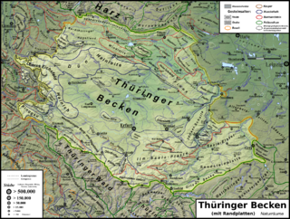
The Thuringian Basin[1][2] (German: Thüringer Becken) is a depression in the central and northwest part of Thuringia in Germany which is crossed by several rivers, the longest of which is the Unstrut. It stretches about 60 kilometres (37 mi) from north to south and around 120 kilometres (75 mi) from east to west. Its height varies from about 150 to 250 m above sea level (NN).
The Basin is surrounded by a wide outer girdle of limestone (Muschelkalk) ridges (including Hainich, Dün, Hainleite, Hohe Schrecke, Schmücke, Finne), and to the southwest by the Thuringian Forest and to the southeast by sharply divided terraces (the Ilm-Saale and Ohrdruf Muschelkalk plateaus, and the Saale-Elster Bunter sandstone plateau). The Thuringian Basin belongs to the triassic period, during which horizontal beds of Bunter sandstone, Muschelkalk and Keuper were laid down. Below those lie the salt and gypsum layers of Magnesian Limestone (Zechstein). In the Cenozoic era the surrounding ridges were uplifted, whilst the Thuringian Basin sank to form a saucer-shaped depression.
The elevation of the Thuringian Basin descends from the south and west to the east. While some of the marginal ridges have the character of low mountain ranges, there are no really noteworthy uplands within it, apart from the Ettersberg and Fahnerscher Höhe.
The Thuringian Basin is dominated by agriculture. Along with the Magdeburg Börde and Leipzig Bay it is one of the richest arable lands in Germany.[3] It was settled in the 8th and 9th century which makes most of the villages and towns in the basin well over 1000 years old. As a result of the fertile countryside, large cities were established very early on in the Basin and on its perimeter (Erfurt and the free imperial city of Mühlhausen).
Other towns in the Thuringian Basin are (year of foundation and year of achieving town status in brackets):
Schlotheim (974/1277)
Ebeleben (1198/1928)
Großenehrich
Greußen/Clingen (?/1353 and 860/1282) to the north,
Kindelbrück (775/1291)
Weißensee (?/1265)
Sömmerda (876/1350)
Kölleda (786/1392)
Rastenberg (1294/1412)
Buttstädt (?/1331)
Buttelstedt (780/1454)
Neumark (1179/1326) to the east,
Gebesee (786/1638)
Bad Tennstedt (772/1340)
Bad Langensalza (932/1212) in the centre
Gotha (775/?) in the south
Large parts of the Basin in the former Thuringian Landgraviate were held by the House of Wettin from 1264 and, after the 1485 Treaty of Leipzig, formed the Thuringian Circle of the Saxon Electorate. Smaller areas used to belong to the Wettin Ernestine duchies and the County of Schwarzburg; the city of Erfurt was a possession of the Mainz Archbishops. According to the 1815 Congress of Vienna, the Albertine and Mainz lands passed to the Kingdom of Prussia, while the smaller areas on the northern and southern rim formed the Thuringian states.
^Kohl, Horst; Marcinek, Joachim and Nitz, Bernhard (1986). Geography of the German Democratic Republic, VEB Hermann Haack, Gotha, pp. 32 ff. ISBN 978-3-7301-0522-1.
^Dickinson, Robert E. (1964). Germany: A regional and economic geography (2nd ed.). London: Methuen.
The ThuringianBasin (German: Thüringer Becken) is a depression in the central and northwest part of Thuringia in Germany which is crossed by several rivers...
the ThuringianBasin, which includes the city Erfurt. The south and south-east continuation of the range is the highland often called the Thuringian-Vogtlandian...
Thuringian Forest, Hörselberge and Hainich. Within the Basin the smaller hill chains Fahner Höhe and Heilinger Höhen. South of the ThuringianBasin is...
and its catchment area is the whole of the ThuringianBasin. It breaks out of the basin through the Thuringian Gate west of Heldrungen and, in its lower...
southern part of the ThuringianBasin, north of the Thuringian Forest, and in the middle of a line of the six largest Thuringian cities (Thüringer Städtekette)...
19th-century commercial boom. Gotha lies in the southern part of the ThuringianBasin in a flat and agricultural landscape. Gotha has existed at least since...
only have one major unit group (Mecklenburg Coastal Lowland, Harz, ThuringianBasin, Upper Main-Upper Palatine Hills, Southern Alpine Foreland), others...
Germany, is where the gorge of the river Unstrut breaks out of the ThuringianBasin through the Hainleite and Schmücke hills to the north. It is also known...
Thuringian blocks (not to be confused with the Saxothuringian Zone) including the Harz, the ThuringianBasin, the Thuringian Forest, the Thuringian-Franconian-Vogtland...
southern border of the ThuringianBasin, a fertile agricultural area between the Harz mountains 70 km (43 mi) to the north and the Thuringian Forest 50 km (31 mi)...
middle section controlled the German indigo (Isatis tinctoria) of the ThuringianBasin as well as the mining products of the Saxon Ore Mountains. The High...
(Normalnull). The following table lists the highest mountains and hills in each Thuringian region: Name, Height, Location (district(s), region); three "???" means...
Schmücke and the Hohe Schrecke, and to the south and southwest by the ThuringianBasin. Sondershausen, capital of Kyffhäuser district Bad Frankenhausen The...
verge of the ThuringianBasin just before the Thuringian Forest, Waltershausen is sometimes referred to as the "gate to the Thuringian Forest". It is...
Riede, after the eruption the area most affected by the fallout, the ThuringianBasin occupied by the Federmesser, appears to have been largely depopulated...
Weissenfels, where the middle Saale emerges from the Buntsandstein of the ThuringianBasin in the Leipzig highlands, not far from the modern-day A9 highway. Parts...
and the Hainleite, the Hohe Schrecke forms the northern rim of the ThuringianBasin. It lies between Braunsroda, Reinsdorf, Gehofen, Donndorf, Wiehe, Lossa...
district, Thuringia, central Germany. Bad Langensalza is located in the ThuringianBasin, the fertile lowlands along the Unstrut river. The river Salza flows...
continued the policy of his father of expanding his influence into the ThuringianBasin by founding castles and monasteries. His marriage to Adelheid of Stade...
 Global Information