River that flows from the eastern Himalayas to the Bay of Bengal
Teesta River
Trisrotā
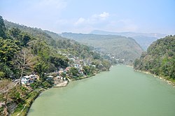
Teesta in Siliguri, West Bengal
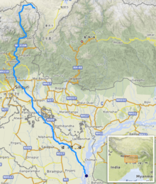
Path of the Teesta
Source of Teesta river in Sikkim
Show map of Sikkim
Teesta River (India)
Show map of India
Location
Country
India
Bangladesh
States
Sikkim, India
West Bengal, India
Rangpur, Bangladesh
Important Bridges
Chungthang Teesta Bridge
Sirwani Teesta Bridge
Indreni Bridge
Rangpo Teesta Bridge
Melli Teesta Bridge
Tista Bazaar Bridge
Coronation Bridge
Sevoke Railway Bridge
Joyee Setu
Jalpaiguri Teesta Bridge
District's
Mangan District
Gangtok District
Pakyong District
Kalimpong district
Darjeeling district
Cooch Behar district
Jalpaiguri district
Rangpur District
Kurigram District
Nilphamari District
Gaibandha District
Lalmonirhat District
Towns & Cities
Chungthang
Mangan
Dikchu
Singtam
Rangpo
Kalimpong
Jalpaiguri
Mekhliganj
Haldibari
Rangpur
Lalmonirhat
Physical characteristics
Source
Pauhunri, Zemu Glacier, Gurudongmar Lake, Tso Lhamo Lake
• location
Sikkim, India
• elevation
7,128 m (23,386 ft)[1]
Mouth
Brahmaputra river
• location
Phulchhari Upazila, Gaibandha, Bangladesh
Length
414 km (257 mi)[1]
Basin size
12,540 km2 (4,840 sq mi)[2]
Basin features
Tributaries
• left
Rangpo River
Lachung River
Ranikhola
Relli River
Talung River
Dik Chhu
Lang Lang Chu
• right
Rangeet River
Kanaka River
Ringyong Chhu
Ranghap Chhu
Teesta River is a 414 km (257 mi) long river that rises in the Pauhunri Mountain of eastern Himalayas, flows through the Indian states of Sikkim and West Bengal and subsequently enters Bangladesh through Rangpur division. In Bangladesh, it merges with Brahmaputra River which after meeting some other major rivers of the Bengal delta finally falls into the Bay of Bengal.[1] It drains an area of 12,540 km2 (4,840 sq mi).[2] In India, the Teesta flows through Mangan District, Gangtok District, Pakyong District, Kalimpong district, Darjeeling District, Jalpaiguri District, Cooch Behar districts and the cities of Rangpo, Jalpaiguri and Mekhliganj. In Bangladesh, it flows through Lalmonirhat District, Rangpur District, Kurigram District and Gaibandha District. It joins the Brahmaputra River at Phulchhari Upazila in Bangladesh. 305 km (190 mi) of the river lies in India and 109 km (68 mi) in Bangladesh. The Teesta is the largest river of Sikkim and second largest river of West Bengal after the Ganges.
^ abcMullick, M. R. A.; Babel, M. S. & Perret, S. R. (2011). "Discharge‐based economic valuation of irrigation water: Evidence from the Teesta River, Bangladesh". Irrigation and Drainage. 60 (4): 481−492. doi:10.1002/ird.597.
^ abRahaman, M. M. & Mamun, A. A. (2020). "Hydropower development along Teesta river basin: opportunities for cooperation". Water Policy. 22 (4): 641–657. doi:10.2166/wp.2020.136.
TeestaRiver is a 414 km (257 mi) long river that rises in the Pauhunri Mountain of eastern Himalayas, flows through the Indian states of Sikkim and West...
Nagar River (Rangpur) Nalia River Padma River Punarbhaba River Pusur River Sangu River Shitalakshya River Surma RiverTeestaRiver Titas River Tulshiganga...
The Rangeet or Rangit is a tributary of the Teestariver, which is the largest river in the Indian state of Sikkim. The Rangeet originates in the Himalayan...
2021. The bridge is about 3.8 km long and crosses the TeestaRiver. Currently, it is the longest river bridge of West Bengal. By the opening of this bridge...
River Kopili River Lohit River Manas River Raidāk River Sankosh River Subansiri RiverTeestaRiver Subarnarekha River Kharkai River Kangsabati River Bhagirathi...
The Lachen River is a tributary of the TeestaRiver in the state of Sikkim, India. It is one of the two main tributaries of the Teesta along with the...
timber and tourism. It is located on the banks of the Mahananda River and the TeestaRiver at the foothills of the Himalayas. Siliguri is the third largest...
as the Sevoke Roadway Bridge, in West Bengal, India, spans across the TeestaRiver, connecting the districts of Darjeeling and Kalimpong. The bridge is...
semi-evergreen forests ecoregion. In Bangladesh, the Brahmaputra is joined by the TeestaRiver (or Tista), one of its largest tributaries. Below the Tista, the Brahmaputra...
north direction. The riverTeesta divides the region in two parts — the region to the east of Teesta and the region to the west of Teesta. This is the highest...
than 500 metres (1,640 ft). "Long Span High Level Road Bridge across TeestaRiver near Haldibari, Coochbehar, West Bengal | SP Singla Constructions Pvt...
gorges of TeestaRiver, which runs from north to south have divided this mountainous region into two parts: the western mountains (west of Teesta) and the...
to the British East India Company (i.e., the area between Mechi River and TeestaRiver). In 1817, through the Treaty of Titalia, the British East India...
using hair. Roy died due to a heart attack during his record try at TeestaRiver.[citation needed] His ponytail became stuck in the wheeler of the rope...
bounded in the west by the Tamur River, in the north by the Lhonak River and Jongsang La, and in the east by the TeestaRiver. It lies in the border region...
the TeestaRiver. The glacier is situated in the west of Pauhunri at 5,400 m (17,700 ft) and has a length of 12.88 kilometre. "Basin Details: Teesta and...
more recently in 2010. The municipality sits on a ridge overlooking the TeestaRiver and is a tourist destination owing to its temperate climate, natural...
great flood on the TeestaRiver, which at the time was a tributary of the Ganges-Padma River. The flood of 1787 caused the Teesta to undergo a sudden...
Subarnarekha River Talma River Tangon RiverTeestaRiver Thakuran River Torsha River Piyali River Murrigonga River Thakhuran River Matala River Goshaba River Harrivnga...
Teesta Bazaar is a village located 4 km (2.5 mi) downstream from the town of Melli on the right bank of TeestaRiver in the Kalimpong I CD block in the...
West Bengal's Kalimpong district and is situated along the Teestariver and Rangpo River. It is the first town of Sikkim lying on National Highway 10...
North Bengal. The city is located on the banks of the TeestaRiver which is the second largest river in West Bengal after the Ganges, on the foothills of...
2016. Retrieved 5 July 2011. "Long Span High Level Road Bridge across TeestaRiver near Haldibari, Coochbehar, West Bengal". SP Singla Constructions. Retrieved...
the Teesta III Dam at Chungthang at midnight, before its gates could be opened, destroying the dam in minutes. Water levels downstream in the River Teesta...
2023-07-22. "My Village My Town Project" (PDF). "Teesta: Bangladesh turns from India to China to transform major river". 21 October 2020. Archived from the original...
River originates as a distributary of TeestaRiver in Nilphamari District. The river flows as the Ghaghot River from its source to Gaibandha, where it...
 Global Information