Tawang Chu (Tawang river) is the main river of the Tawang district in Arunachal Pradesh, India. The entire district may be regarded as the basin of the Tawang Chu river. In addition, two south-flowing rivers from Tibet, viz., Tsona Chu and Nyamjang Chu, join the river within the district. The combined river flows west into Bhutan, where it progresses to the Manas River (tributary of Brahmaputra River) and flows into the Assam state of India.
Tawang Chu is formed by the joining of three rivers originating within the Tawang district: Goshu Chu, Dungma Chu and Gorjo Chu. These rivers merge near the village of Mago (27°41′15″N92°12′26″E / 27.6876°N 92.2072°E / 27.6876; 92.2072 (Mago)), after which the combined river is called Mago Chu. After Tsona Chu joins it, near Kyelatongbo at an elevation of 2,240 metres (7,350 ft), the combined river is called Tawang Chu. The river flows west towards Bhutan, passing by the Tawang town on its southern flank.[1] Near Jang, between Mago & Tawang, the Nuranang River joins Tawang Chu. Near Lumla, the Nyamjang Chu river originating in Tibet joins Tawang Chu.
Tawang Chu enters Bhutan after passing the Dudunghar Circle of the Tawang district. At Duksum, the river merges with the Kholong Chu river flowing from the north.[2] The combined river is called Drangme Chhu (or Manas River).
The Tawang Chu and its tributaries
^Tawang District Census Handbook, Part A(PDF), Directorate of Census Operations, Arunachal Pradesh, 2011, p. 3 (The Tsona Chu river is misnamed as "Nyukcharong" in this description. Nyukcharong is a separate river that flows entirely within the Tawang district. It joins Tsona Chu before its confluence with Mago Chu.)
^
Kholong Chhu, OpenStreetMap, retrieved 14 December 2022.
TawangChu (Tawang river) is the main river of the Tawang district in Arunachal Pradesh, India. The entire district may be regarded as the basin of the...
of approximately 3,048 metres (10,000 ft). It lies to the north of the TawangChu river valley, roughly 10 miles (16 km) south of the Line of Actual Control...
It is situated in the valley of the TawangChu, in close proximity to the Chinese and Bhutanese border. Tawang Monastery is known in Tibetan as Gaden...
the Yangtse region of Tawang. Later Chinese army retreat and Indian army won in clash. Tawang district, the basin of TawangChu, occupies an area of 2...
standoff took place between India and China in the Sumdorong Chu Valley bordering the Tawang district, Arunachal Pradesh and Cona County, Tibet. It was...
Tibet and the Tawang district of Arunachal Pradesh. It originates in the Tokpo Shiri Glacier, about 7–10 kilometres east of Nyamjang Chu, and flows down...
joining the TawangChu river just before it enters Bhutan. The Nyamjang Chu valley has provided the traditional communication route between Tawang and Tibet...
cluster of mountains, on a watershed between the Tsona Chu river in Tibet and the TawangChu in the Tawang district. The watershed ridge forms the border between...
is a major feature of the geography of the state. Other rivers include TawangChu, Dikrong, Ranga, Kamala/Kamla, Kamplang, Siyum, Dihing/ Noadihing and...
Chu and Tsona Chu flow through the county and enter India's Tawang district, where they join the TawangChu river. Between Nyamjang Chu and Tsona Chu...
city in Tibet (now China). The route passed through the Nyamjang Chu and TawangChu rivers via Trashigang and Dewangiri. The Monpas of Tibet would visit...
(35 km) north of Tawang and 4 miles (6.4 km) west of Bum La Pass, which is a border trading point between India and China. The Taktsang Chu river that originates...
Yangtse, the TawangChu is joined by the Kholong Chu, which rises in the northern Himalaya snow ranges of Bhutan. Further downstream, the Gamri Chu, flowing...
of an eponymous circle in the Tawang district of Indian state of Arunachal Pradesh. It is on the bank of the Nyamjang Chu river, which originates in Tibet...
trade route between Tawang in India's Arunachal Pradesh and Tsona Dzong in Tibet's Shannan province via the valley of Tsona Chu. The Ludlow–Sherriff...
Road in the Tawang district of Arunachal Pradesh state of India. Jang is 40 km southeast of Tawang, north of Sela Tunnel, and between Tawang and Bomdila...
India Intelligence Bureau personnel in the Tawang region set up an observation post in the Sumdorong Chu Valley just south of the highest hill crest...
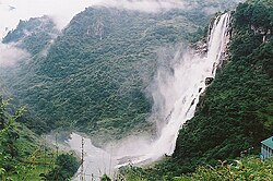
Falls are in an area called Yangtse where the Tsona Chu river flows from Tibet into India's Tawang district. They are along the cliff face of a high plateau...
area of Tawang, retreating to Sela and Bomdila. 5km 3miles New Khinzemane Post Tawang Bum La Thagla ridge Sumdorong Chu Nyamjang Chu Nyamjang Chu Nyamjang...
all-important Sela pass, which provides India's gateway to the Tawang region. The Tsona Chu river meanders through Tsona County in southern Tibet before...
the much-revered Tawang Monastery.A research report claimed that foundation of the Samten Yongcha monastery is older than that of Tawang Monastery. The...
is located on top of the hill rising between the Rathong chu and the Rangeet River. Tawang Monastery in the Indian state of Arunachal Pradesh is the...
(Jia Bharali) in Assam) in the eastern Himalayan mountains, originates in Tawang district from the glacial lake below snow-capped Gori Chen mountain 27°48′36″N...
 Global Information