 Global Information
McMahon Line information
The examples and perspective in this article may not include all significant viewpoints. (July 2020) |


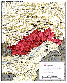
The McMahon Line is the boundary[1] between Tibet and British India as agreed in the maps and notes exchanged by the respective plenipotentiaries on 24–25 March 1914 at Delhi,[2] as part of the 1914 Simla Convention. The line delimited the respective spheres of influence of the two countries in the eastern Himalayan region along northeast India and northern Burma (Myanmar), which were earlier undefined.[3][4][a] The Republic of China was not a party to the McMahon Line agreement,[6] but the line was part of the overall boundary of Tibet defined in the Simla Convention, initialled by all three parties and later repudiated by the government of China.[7][b] The Indian part of the Line currently serves as the de facto boundary between China and India, although its legal status is disputed by the People's Republic of China.[12][13] The Burmese part of the Line was renegotiated by the People's Republic of China and Myanmar.
The line is named after Henry McMahon, foreign secretary of British India and the chief British negotiator of the conference at Simla. The bilateral agreement between Tibet and Britain was signed by McMahon on behalf of the British government and Lonchen Shatra on behalf of the Tibetan government.[14] It spans 890 kilometres (550 miles) from the corner of Bhutan to the Isu Razi Pass on the Burma border, largely along the crest of the Himalayas.[15][16]
The outcomes of the Simla Conference remained ambiguous for several decades because China did not sign the overall Convention but the British were hopeful of persuading the Chinese. The Convention and the McMahon's agreement were omitted in the 1928 edition of Aitchison's Treaties.[17] It was revived in 1935 by Olaf Caroe, then deputy foreign secretary of British India, who obtained London's permission to implement it as well as to publish a revised version of Aitchison's 1928 Treaties.[c] Since then the McMahon Line has been part of the legal national border of India.
China rejects the Simla Convention and the McMahon Line, contending that Tibet was not a sovereign state and therefore did not have the power to conclude treaties.[20] However China recognizes the line as part of the Line of Actual Control between the two countries, according to a 1959 diplomatic note by Prime Minister Zhou Enlai.[21] Chinese maps show some 65,000 km2 (25,000 sq mi) of the territory south of the line as part of the Tibet Autonomous Region, known as South Tibet in China.[22] Chinese forces briefly occupied a part of this area during the Sino-Indian War of 1962 and later withdrew.
The 14th Dalai Lama did not originally recognise India's sovereignty over Arunachal Pradesh. As late as 2003, he said that "Arunachal Pradesh was actually part of Tibet".[23] In January 2007, however, he said that both the Tibetan government and Britain recognized the McMahon Line in 1914. In June 2008, he explicitly recognized for the first time that "Arunachal Pradesh was a part of India under the agreement signed by Tibetan and British representatives".[23]
- ^ Lamb, The McMahon Line, Vol. 1 1966, p. 4: "The main British gain from the Simla Conference was the delimitation of the McMahon Line, the boundary along the crest of the Assam Himalayas from Bhutan to Burma, by means of an exchange of Anglo-Tibetan notes."
- ^ Mehra, The McMahon Line and After (1974), p. 230: "To give their agreement shape and form, McMahon and Lonchen exchanged formal letters and copies of maps showing the boundary. This was done at Delhi on 24–25 March."
- ^ Mehra, The McMahon Line and After (1974): Quoting Lord Crew, British Secretary of State for India: "that by a definition of the boundary between Tibet and India he (Crewe) understands the Government of India to mean an agreement as to the spheres, at present undefined, of the two countries in the tribal territory east of Bhutan"
- ^ Mehra, The McMahon Line and After (1974), p. 225: "there was no intention of 'administering' the country 'within the proposed frontier line much less of undertaking 'military operations' in the area in question. And yet,... it was desirable 'to maintain some semblance of authority that could be backed by force, 'if necessary'."
- ^ Lin, Boundary, sovereignty and imagination (2004), p. 26: "As the following discussion reveals, the professed sovereignties claimed by both Republican China and British India over the Assam-Tibetan tribal territory were largely imaginary, existing merely on official maps and political propagandas."
- ^ Shakya, The Dragon in the Land of Snows (1999), p. 279
- ^ Mehra, India–China Border (1982), p. 834: 'The McMahon Line (ML), shown by a Red line on the 1914 map, was an integral part of a longer, more comprehensive line drawn on the convention map to illustrate Article IX thereof... The map is initialled by the three plenipotentiaries 'in token of acceptance" on "this 27th day of April 1914".'
- ^ Lamb, The McMahon Line, Vol. 2 (1966), p. 552.
- ^ Mehra, India–China Border (1982), p. 834.
- ^ Choudhury, The North-East Frontier of India (1978), pp. 154–157.
- ^ Smith, Tibetan Nation (1996), p. 200.
- ^ Claude Arpi (2008). Tibet: The Lost Frontier. Lancer Publishers LLC. pp. 70–. ISBN 978-1-935501-49-7. Archived from the original on 28 July 2023. Retrieved 24 May 2017.
- ^ Emmanuel Brunet-Jailly (28 July 2015). Border Disputes: A Global Encyclopedia [3 volumes]: A Global Encyclopedia. ABC-CLIO. pp. 542–. ISBN 978-1-61069-024-9. Archived from the original on 28 July 2023. Retrieved 24 May 2017.
- ^ Rao, Veeranki Maheswara (2003). Tribal Women of Arunachal Pradesh: Socio-economic Status. Mittal Publications. pp. 60–. ISBN 978-81-7099-909-6. Archived from the original on 28 July 2023. Retrieved 25 May 2017.
- ^ Richardson, Tibet and its History, p. 116.
- ^ "Burma–China Boundary", International Boundary Study, United States Department of State, 1964 – via archive.org: "In negotiating a boundary between British India and Tibet, the line was drawn to include Burma as far east as the Isu Razi pass, south of the Taron River near the Irrawaddy-Salween watershed."
- ^ Mehra, A Forgotten Chapter (1972), pp. 304–305: "for nearly two decades after 1914, the dubious risk of attracting Russian, and later Chinese, attention continued to be the principal reason for the non-publication of the Simla Convention and its adjuncts, the Trade Regulations and the India Tibet boundary agreement."
- ^ Addis, J. M. (April 1963), The India–China Border Question (PDF), Harvard University, p. 27, archived (PDF) from the original on 9 July 2021, retrieved 6 July 2021
- ^ Van Eekelen, Indian Foreign Policy and the Border Dispute (2015): "In his Introduction to the Addis Paper Neville Maxwell makes much of this 'dramatic discovery' which in his opinion revealed British diplomatic forgery to induce China/Tibet to cede a broad tract of territory. P. Mehra, p. 419, saw the reason in the sensitivity of the Trade Regulations of 1914 and the policy of 'letting sleeping dogs lie'. Noorani, p. 199, thought the change unnecessary and clumsy as Bell's Tibet Past and Present of 1924 p. 155, had already given the story and map."
- ^ Lamb, The McMahon Line, Vol. 1 (1966)[page needed]
Grunfeld, The Making of Modern Tibet (1996)[page needed] - ^ Cite error: The named reference
Noorani perseverancewas invoked but never defined (see the help page). - ^ "About South Tibet" (in Chinese). 21cn.com (China Telecom). 18 November 2008. Archived from the original on 22 January 2012. Retrieved 18 February 2012.
- ^ a b "Tawang is part of India: Dalai Lama". 4 June 2008. Archived from the original on 25 January 2011. Retrieved 20 August 2012.
Cite error: There are <ref group=lower-alpha> tags or {{efn}} templates on this page, but the references will not show without a {{reflist|group=lower-alpha}} template or {{notelist}} template (see the help page).