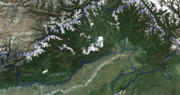
Arunachal Pradesh is primarily a hilly tract nestled in the foothills of the Himalayas in northeast India. It is spread over an area of 83,743 km2 (32,333 sq mi).[3] 98% of the geographical area is land out of which 80% is forest cover;[1] 2% is water.[4] River systems in the region, including those from the higher Himalayas and Patkoi and Arakan Ranges, eventually drain into the Brahmaputra River.[5]
Elevation ranges from mountains that are above 7,000 metres (23,000 ft),[6] to the towns in the plains with an elevation of less than 300 metres (980 ft).[7] Arunachal shares international borders with Bhutan, Tibet (China) and Burma (Myanmar). Internally, Arunachal borders the states of Assam and Nagaland. Arunachal is called the "orchid state of India"[8][9] and "dawn-lit mountain/Land of Dawn/Land of Dawn-Lit Mountains".[10][11]
^ abcISFR Vol 1, Forest Survey of India (2019), pg. 24.
^AP State Action Plan (2011), pp. 12.
^"Arunachal Pradesh: Physiography, At a glance". gbpihedenvis.nic.in. Hosted by: G.B. Pant National Institute of Himalayan Environment and Sustainable Development. Sponsored by: Ministry of Environment, Forest & Climate Change, Govt of India. ENVIS Centre on Himalayan Ecology. Retrieved 23 June 2021.{{cite web}}: CS1 maint: others (link)
^"4 Reasons Why Arunachal Pradesh is a Natural Wonderland". Outlook India Traveller. 26 June 2018. Retrieved 23 June 2021. We may as well call Arunachal a flowery paradise. Arunachal is also called Orchid State of India
^"Launching IUCN Red-listing Process for Orchids in Arunachal Pradesh, India". IUCN. 3 December 2020. Retrieved 23 June 2021. The biodiversity rich North-East States in India are endowed with over 870 species in 159 genera constituting over 73% of the total Orchid species reported from India. Arunachal Pradesh has the highest number of orchid species (around 622 species) reported from the state. Arunachal Pradesh has also been termed as 'Orchid Paradise of India' because of the maximum concentration of orchid species (about 40% of the country) in the State.
^Bolingbroke-Kent, Antonia (15 June 2017). Land of the Dawn-lit Mountains. Simon and Schuster. ISBN 978-1-4711-5657-1.
^Arunachal Pradesh: Human Development Report (2005), pg. 3.
and 15 Related for: Geography of Arunachal Pradesh information
ArunachalPradesh is primarily a hilly tract nestled in the foothills of the Himalayas in northeast India. It is spread over an area of 83,743 km2 (32...
an overview of and topical guide to ArunachalPradesh: ArunachalPradesh – northeasternmost state of the Republic of India. Geographically, it is the largest...
ArunachalPradesh (/ɑːrəˌnɑːtʃəl prəˈdɛʃ/, lit. 'Dawn-Lit Mountain Province') is a state in northeast India. It was formed from the North-East Frontier...
ArunachalPradesh Congress Committee (or Arunachal PCC) is the state wing of Indian National Congress serving in ArunachalPradesh. It is responsible for...
As of February 2024[update], the Indian state ArunachalPradesh comprised 28 districts, including Itanagar capital complex, with more districts proposed...
1934, ArunachalPradesh, India – 2000) was an Indian politician. He was the President of the Peoples Party ofArunachal and was the Chief Minister of Arunachal...
one of the 28 districts ofArunachalPradesh state in northeastern India. Napangphung is its headquarters. In November 2023, the ArunachalPradesh Chief...
Keyi Panyor is one of the 28 districts ofArunachalPradesh state in northeastern India. Yachuli is its headquarters. In December 2022, the All Yachuli...
the Indian states and union territories of Ladakh, Himachal Pradesh, Uttarakhand, Sikkim and ArunachalPradesh. The border with Burma (Myanmar) extends...
Arunachal languages are various languages in ArunachalPradesh, India traditionally classified as Sino-Tibetan languages, but that may be language isolates...
Sanctuary is one of the eight wildlife sanctuaries ofArunachalPradesh, India. It is located in the Upper Dibang Valley district covering an area of 4,149 km2...
mountain of the Eastern Himalayas located in the Indian state ofArunachalPradesh and it shares its border with the Tibet Autonomous Region of China. It...
district ofArunachalPradesh State, India. This district was created in 2015 by carving it out of the West Siang and East Siang districts ofArunachal Pradesh...
 Global Information