The Aquino Bridge is one of the two bridges constructed across the Tarlac River in Tarlac City to connect the western portion of the city to the Poblacion Area.
The Tarlac River is a river in Central Luzon Philippines, it is the longest tributary of the Agno River with a total length of 95.2 km (59.2 mi) covering a drainage area of 1,900 square kilometres (730 sq mi) traversing the provinces of Tarlac and Pangasinan.[1] The river originates around the vicinity of Mount Pinatubo and empties itself into the Agno River at Poponto Swamp located between the boundaries of Tarlac and Pangasinan. It was formerly the site of traditional balsa or bamboo raft riding, until the river was heavily silted by sticky lahar or mud flow brought by the eruption of Mount Pinatubo on June 15, 1991, filling the river with over 10 feet (3.0 m) of lahar. Its main tributary is the O'Donnel River in Santa Lucia, Capas, Tarlac.
The Tarlac River is dammed at Barangay Tibag in Tarlac City where its water is used for irrigation and distributed to the northern and central regions of Tarlac, the rest of the river is now a bed of sand. The river was once a good source of fish and water used for irrigation, the irrigation system now takes just about "all" of the remaining water and distributes it to barangays in Tarlac City such as Matatalaib and Maliwalo. The river bed is also being used as a source of sand and stones that can be used as construction materials.
The Tarlac River flowing northward as viewed from the Tarlac City public market
The Tarlac River as viewed from the Tarlac City public market
The Tibag Bridge is one of the two bridges constructed across the Tarlac River in Tarlac City to connect the western portion of the city to the Poblacion Area
^"Hydrometeorology-Agno River Basin". Philippine Atmospheric, Geophysical and Astronomical Services Administration. PAGASA Northern Luzon. Retrieved 9 October 2013.
The TarlacRiver is a river in Central Luzon Philippines, it is the longest tributary of the Agno River with a total length of 95.2 km (59.2 mi) covering...
Tarlac, officially the Province of Tarlac (Kapampangan: Lalawigan ning Tarlac; Pangasinan: Luyag/Probinsia na Tarlac; Ilocano: Probinsia ti Tarlac; Tagalog:...
Tarlac City, officially the City of Tarlac (Kapampangan: Lakanbalen ning Tarlac; Pangasinan: Siyudad na Tarlac; Ilocano: Siudad ti Tarlac; Filipino: Lungsod...
Pangasinan, and Tarlac, it is one of the largest river systems in the country, with a drainage area of 5,952 square kilometres (2,298 sq mi). The river originates...
Capas and Tarlac. Before the advent of the Spanish era, small settlers came, attracted by the fertile land and the glittering silver of the river that cut...
Sapang Baho River Siniloan RiverTarlacRiver Tullahan River Tunasan River Umiray River Yawa River Zapote River Abatan River, Bohol Aklan River, Panay Anilao...
Tagalog: Bayan ng Capas), is a 1st class municipality in the province of Tarlac, Philippines, and one of the richest towns in the province. The town also...
of rivers in Zambales Mountains by length. TarlacRiver 95.2 km (59.2 mi) Camiling River 93 km (58 mi) Pasig–Potrero River 75 km (47 mi) Bucao River 48...
abandoned and closed. San Fernando-Dagupan closed in 1983, Dagupan-Tarlac in 1988 and Tarlac-Malolos in 1989. The eruption of Mount Pinatubo further shortened...
Subic–Clark–Tarlac Expressway (SCTEX) and Tarlac–Pangasinan–La Union Expressway (TPLEX) in Tarlac City. The expressway intersects Santa Rosa–Tarlac Road at...
Tarlac in the Philippines. According to the 2020 census, it has a population of 87,319 people. Camiling is one of the fastest-growing towns of Tarlac...
at the national highway to Camiling, Tarlac just after the then Tarlac College of Agriculture (now the Tarlac Agricultural University) campus. The town...
that connects the provinces of Tarlac and Pangasinan. It is alternatively known as Tarlac–Pangasinan Road from Tarlac City to Bugallon, Pangasinan and...
Metro Manila and Southern Tagalog. The Pampanga River Basin and the Agno River Basin converged over Tarlac, submerging that province. At the higher sections...
boundary of Tarlac and Pangasinan provinces. This 25-square kilometer swamp can be found at the confluence of the Agno and Tarlacrivers. It is near the...
expressways in Luzon have been connected to at least one other expressway. Tarlac–Pangasinan–La Union Expressway Extension (Rosario to San Juan, La Union)...
ownership issues of the heritage house. The historical marker for José Rizal in Tarlac City was reported to be in a state of rot in 2011. The marker was relocated...
Caloocan, and Valenzuela into the northern provinces of Bulacan, Pampanga, Tarlac, Pangasinan, and La Union. The portion of R-8 between Guiguinto and Balintawak...
located on the tripoint boundary of the Philippine provinces of Zambales, Tarlac and Pampanga, all in Central Luzon on the northern island of Luzon. Its...
the province of Tarlac, Philippines. It is located in municipality of San Jose, Tarlac. Water from the mountain drains to the Agno River. With an elevation...
Botolan in Zambales, Porac and Mabalacat in Pampanga, Tarlac City, Capas, Concepcion and Bamban in Tarlac. The Bamban Bridge on the MacArthur Highway, a major...
McLeary The Work (publication), a student newspaper in Tarlac City, Philippines The Work (Rivers of Nihil album), 2021 The Work (Gold Panda album), 2022...
526 in 2010. They live mainly in the provinces of Pampanga, Bataan and Tarlac, as well as Bulacan, Nueva Ecija and Zambales. The province of Pampanga...
 Global Information
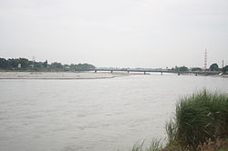


 The Tarlac River flowing northward as viewed from the Tarlac City public market
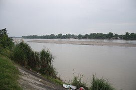 The Tarlac River as viewed from the Tarlac City public market
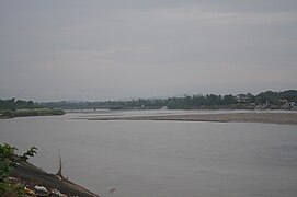 The Tibag Bridge is one of the two bridges constructed across the Tarlac River in Tarlac City to connect the western portion of the city to the Poblacion Area

