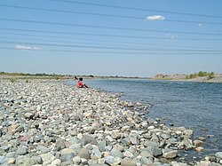
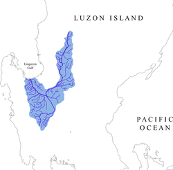
The Agno River, also known as the Pangasinan River, is a river on the island of Luzon in the Philippines. Traversing the provinces of Benguet, Pangasinan, and Tarlac, it is one of the largest river systems in the country, with a drainage area of 5,952 square kilometres (2,298 sq mi).[2][3][4][5]
The river originates in the Cordillera Mountains and empties into the South China Sea via Lingayen Gulf. The river is 248 kilometres (154 mi) long, making it the sixth longest river in the country.[6] Roughly two million people live in the Agno River Valley, making it one of Philippines' larger population clusters.
The river is dammed by three hydroelectric power plants: the Ambuklao Dam in Bokod, the Binga Dam in Itogon, and the San Roque Dam in San Manuel.
^Tuddao, Vicente B. Jr. (September 21, 2011). "Water Quality Management in the Context of Basin Management: Water Quality, River Basin Management and Governance Dynamics in the Philippines" (PDF) (Deck). Department of Environment and Natural Resources. Archived (PDF) from the original on August 29, 2016. Retrieved April 5, 2017.
^"The Agno River Basin". ABSCBNNEws.com. October 23, 2009. Archived from the original on December 3, 2013. Retrieved October 25, 2013.
^"Agno River Basin". PAGASA Regional Service Division. Archived from the original on October 21, 2013. Retrieved October 21, 2013.
^Petr, T., ed. (1985). Inland Fisheries in Multiple-purpose River Basin Planning and Development in Tropical Asian Countries: Three Case Studies. Rome: Food and Agriculture Organization of the United Nations. p. 20. ISBN 92-5-102327-1.
^Kundel, Jim (April 3, 2008). "Water Profile of Philippines". The Encyclopedia of Earth. Archived from the original on September 21, 2008. Retrieved September 30, 2008.
^Kenneth Kimutai too (July 24, 2018). "Longest Rivers in the Philippines". WorldAtlas. Archived from the original on August 26, 2019. Retrieved September 9, 2019.
The AgnoRiver, also known as the Pangasinan River, is a river on the island of Luzon in the Philippines. Traversing the provinces of Benguet, Pangasinan...
The Tarlac River is a river in Central Luzon Philippines, it is the longest tributary of the AgnoRiver with a total length of 95.2 km (59.2 mi) covering...
Abra River Abulog RiverAgnoRiver Angat River Apayao River Balili River Bay River Bicol River Libmanan River Mangayawan River Naga River Yabu River Bued...
Agno may refer to: Agno, Pangasinan Agno, Switzerland AgnoRiver, Republic of the Philippines Torrente Agno, a river in Province of Vicenza, Italy This...
of water is the AgnoRiver, which originates from Mount Data. The dam is located in a conservation area known as the Upper AgnoRiver Basin Resource Reserve...
two forces were to press south past Rosario to secure the bank of the AgnoRiver, the first major geographic obstacle on the road to Manila. However, the...
between the Zambales Mountains and the Cordillera Central. The AgnoRiver and the Balili River drain into Lingayen Gulf. The gulf has numerous islands, the...
the Lower Agno WFR Protected Area Management Board under the Department of Environment and Natural Resources, Lower Agno follows the AgnoRiver corridor...
The Upper AgnoRiver Basin Resource Reserve is a protected area located on the southeast flank of the Cordillera Central in the Philippine province of...
largest dam is the 1.2-kilometer-long (0.75 mi) San Roque Dam on the AgnoRiver in Pangasinan. The Malampaya gas field, discovered in the early 1990s...
municipalities of Asingan and Santa Maria in Pangasinan, Philippines. Crossing the AgnoRiver, it is part of the Asingan–Sta Maria Road It is the longest bridge in...
nilubyan. Camiling began its history as a settlement located near the Camiling River. During the classical era, the area used to be lush in tropical rainforest...
"impracticable". He requested and was given permission to withdraw behind the AgnoRiver. MacArthur decided to abandon his own plan for defense and revert to WPO-3...
provincial capital, Lingayen. Villasis is a farming town situated along the AgnoRiver. On its borders are the towns of Malasiqui (on the west), Urdaneta City...
Urbiztondo, officially the Municipality of Urbiztondo (Pangasinan: Baley na Urbiztondo; Ilocano: Ili ti Urbiztondo; Tagalog: Bayan ng Urbiztondo), is a...
took place in placer deposits along the AgnoRiver, the Bued River, the Suyoc River, and the Amburayan River. Gold was also mined from lode veins within...
protected as part of the Lower Agno Watershed Forest Reserve and Upper AgnoRiver Basin Resource Reserve. The AgnoRiver traverses the municipality and...
Binga Dam is a dam in AgnoRiver connected to a hydroelectric power plant situated at Barrio Binga, Barangay Tinongdan in the municipality of Itogon in...
a sovereign pre-colonial Philippine polity (panarian) located in the AgnoRiver basin and delta, with Binalatongan as the capital. Places in the present-day...
runway for several attack planes. It is located along Lingayen Gulf, the AgnoRiver and the Limahong Channel. It has a land area of 62.76 square kilometers...
Luzon, plus Metro Manila and Southern Tagalog. The Pampanga River Basin and the AgnoRiver Basin converged over Tarlac, submerging that province. At the...
Mangatarem, officially the Municipality of Mangatarem (Pangasinan: Baley na Mangatarem; Ilocano: Ili ti Mangatarem; Tagalog: Bayan ng Mangatarem), is a...
Philippines (27th Lancers) Northern Plains Mansions CSI and Royal Malls AgnoRiver Flood Control Project, Bacnono Rock Island Resort Mangabul lake St. Vincent...
 Global Information