Between 635,000 ± 80,000 and 1.1 ± 0.09 million years[2]
Mountain type
Stratovolcano[1]
Volcanic arc/belt
Luzon Volcanic Arc
Last eruption
November 30, 2021[3]
Part of a series on the
History of the Philippines
Timeline
Prehistoric period (pre-900)
Early hominin activity
Homo luzonensis
Tabon Man
Austronesian expansion
Angono Petroglyphs
Lal-lo and Gattaran Shell Middens
Jade culture
Sa Huỳnh culture
Precolonial barangay
Maritime Silk Road
Events/Artifacts
Balangay
Cordillera Rice Terraces
Grave goods
Kalanay Cave
Maitum anthropomorphic pottery
Manunggul Jar
Prehistoric beads
Shell tools
Precolonial period (900–1565)
Historically documented states/polities
(north to south)
Caboloan
Cainta
Tondo
Namayan
Maynila
Ibalon
Ma-i
Pulilu
Sandao
Madja-as
Dapitan
Cebu
Butuan
Sanmalan
Sultanate of Maguindanao
Sultanate of Buayan
Sultanates of Lanao
Sultanate of Sulu
Events/Artifacts
Maragtas
Laguna Copperplate Inscription
Butuan Ivory Seal
Limestone tombs of Kamhantik
Kabayan Mummies
Baybayin
Batanes Ijang fortresses
Golden Tara of Agusan
Monreal Stones
Butuan Silver Paleograph
Piloncitos
Barter rings
Luzones
Magellan expedition
Battle of Mactan
Spanish colonial period (1565–1898)
Events
Voyage of Miguel López de Legazpi
Sandugo
Treaty of Cebu
Blockade of Cebu
Spanish capture of Manila
Battle of Bangkusay
New Spain
Spanish East Indies
Captaincy General
Tondo Conspiracy
Manila galleon
Revolts and uprisings
Spanish–Moro conflict
Battles of La Naval de Manila
British invasion
Propaganda Movement
1872 Cavite mutiny
La Liga Filipina
Katipunan
Cry of Pugad Lawin
Philippine Revolution
Tejeros Convention
Republic of Biak-na-Bato
Spanish–American War
Treaty of Paris (1898)
Battle of Manila Bay
Declaration of Independence
American capture of Manila
Malolos Congress
First Republic
Philippine–American War
Artifacts
Boxer Codex
Doctrina Christiana
UST Baybayin Documents
Velarde map
American colonial period (1898–1946)
Tagalog Republic
Negros Republic
Zamboanga Republic
Military Government
Moro Rebellion
Insular Government
Jones Law
Tydings–McDuffie Act
Commonwealth
World War II
Japanese occupation
Battle of Bataan
Battle of Corregidor
Second Republic
Philippine resistance
Hukbalahap
Battle of Leyte Gulf
Philippines campaign
Post-independence (1946–1965)
Third Republic
Treaty of Manila
Mutual Defense Treaty
Hukbalahap Rebellion
Filipino First policy
North Borneo dispute
Marcos era (1965–1986)
Communist rebellion
Moro conflict
Martial law
Fourth Republic
People Power Revolution
Contemporary period (1986–present)
Fifth Republic
1997 Asian financial crisis
2000 campaign against the MILF
2nd People Power Revolution
EDSA III
Oakwood mutiny
Philippine drug war
Territorial disputes
Siege of Marawi
Bangsamoro
COVID-19 pandemic
By topic
Ancient religions
Rulers
Queen consorts
Administrative divisions
Agriculture
Archaeology
Communications
Conflicts
Cultural achievements
Diet and health
Education
Economy
Geography
Historiography
Languages
Medicine
Military
Names
Politics
Science and technology
World Heritage Sites
Philippines portal
v
t
e
Mount Pinatubo[4] is an active stratovolcano in the Zambales Mountains, located on the tripoint boundary of the Philippine provinces of Zambales, Tarlac and Pampanga, all in Central Luzon on the northern island of Luzon.[5][6] Its eruptive history was unknown to most before the pre-eruption volcanic activity of early 1991. Pinatubo was heavily eroded and obscured from view by dense forests which supported a population of several thousand indigenous Aetas.
Pinatubo is most notorious for its VEI-6 eruption on June 15, 1991, the second-largest terrestrial eruption of the 20th century after the 1912 eruption of Novarupta in Alaska.[7] Complicating the eruption was the arrival of Typhoon Yunya, bringing a lethal mix of ash and rain to towns and cities surrounding the volcano. Predictions at the onset of the climactic eruption led to the evacuation of tens of thousands of people from the surrounding areas, saving many lives. Surrounding areas were severely damaged by pyroclastic surges, pyroclastic falls, and subsequently, by the flooding lahars caused by rainwater re-mobilizing earlier volcanic deposits. This caused extensive destruction to infrastructure and changed river systems for years after the eruption.[7][8] Minor dome-forming eruptions inside the caldera continued from 1992 to 1993.
The effects of the 1991 eruption were felt worldwide. It erupted roughly 10 billion tonnes (1.1×10¹⁰ short tons) or 10 km3 (2.4 cu mi) of magma, and 20 million tonnes (22 million short tons) of SO 2, bringing vast quantities of minerals and toxic metals to the surface environment. It ejected more particulate into the stratosphere than any eruption since Krakatoa in 1883. Over the following months, the aerosols formed a global layer of sulfuric acid haze. Global temperatures dropped by about 0.5 °C (0.9 °F) in the years 1991–1993,[9] and ozone depletion temporarily saw a substantial increase.[10]
^"Pinatubo". Global Volcanism Program. Smithsonian Institution. Archived from the original on January 23, 2020. Retrieved January 23, 2020.
^"Pinatubo Volcano". The Philippine Institute of Volcanology and Seismology (PHIVOLCS). Archived from the original on January 29, 2009. Retrieved August 12, 2008.
^"Pinatubo: Eruptive History". Global Volcanism Program. Smithsonian Institution. Retrieved August 31, 2021.
^Sambal: Bakil nin Pinatobo; Kapampangan: Bunduk/Bulkan ning Pinatubu, Bunduk ning Apu Malyari; Pangasinan: Palandey/Bulkan na Pinatubu; Ilocano: Bantay Pinatubo; Tagalog: Bundok/Bulkang PinatuboIPA:[pinɐtubɔ]
^"Tarlac map". University of Texas in Austin Library. Archived from the original on July 31, 2019. Retrieved August 2, 2011.
^"Report of the Philippine Commission to the President, 1901 Vol. III" Archived November 30, 2016, at the Wayback Machine, pg. 141. Government Printing Office, Washington, 1901.
^ ab"The Cataclysmic 1991 Eruption of Mount Pinatubo, Philippines". Archived from the original on August 25, 2013. Retrieved April 9, 2007. This article incorporates text from this source, which is in the public domain.
^Rodolfo; Umbal; Alonso. "Two Years of Lahars on the Western Flank of Mount Pinatubo: Initiation, Flow Processes, Deposits, and Attendant Geomorphic and Hydraulic Changes". USGS Publications. Archived from the original on March 16, 2012. Retrieved March 7, 2012.
^Stephen Self; Jing-Xia Zhao; Rick E. Holasek; Ronnie C. Torres & Joey McTaggart (1999). "The Atmospheric Impact of the 1991 Mount Pinatubo Eruption". Archived from the original on August 2, 2014. Retrieved July 25, 2014.
^"Mt. Pinatubo's cloud shades global climate". Science News. Archived from the original on January 7, 2012. Retrieved March 7, 2010.
MountPinatubo is an active stratovolcano in the Zambales Mountains, located on the tripoint boundary of the Philippine provinces of Zambales, Tarlac and...
The 1991 eruption of MountPinatubo in the Philippines' Luzon Volcanic Arc was the second-largest volcanic eruption of the 20th century, behind only the...
Lake Pinatubo (Filipino: Lawa ng Pinatubo) is the summit crater lake of MountPinatubo formed after its climactic eruption on June 15, 1991. The lake...
miles (16 km) to the west of Mount Arayat is Angeles City and the former Clark Air Base. The active volcano MountPinatubo is located 26 km (16 mi) west...
destroy any structures in their path. Notable lahars include those at MountPinatubo and Nevado del Ruiz, the latter of which killed thousands of people...
claimed thousands of lives. In modern times, Mount St. Helens in Washington State, US, and MountPinatubo in the Philippines have erupted catastrophically...
institutional and social responses to the eruption and the lahars of MountPinatubo volcano from 1991 to 1998 (Central Luzon, Philippines)." GeoJournal...
1991, MountPinatubo, 20 miles (32 kilometres) from the city, violently erupted with a force eight times greater than the May 1980 eruption of Mount St....
Philippines. The lake was created after the cataclysmic eruption of MountPinatubo in 1991. Lahars following the eruption blocked the drainage of Mapanuepe...
lease of Subic Bay Naval Base by the US for ten years. The eruption of MountPinatubo in June 1991 influenced the United States' decision to abandon the nearby...
negotiated 2014/5. Basa Air Base suffered heavy infrastructural damage when MountPinatubo, less than 15 miles (24 km) away, erupted in 1991. This left most buildings...
phreatomagmatic. MountPinatubo is on the Central Luzon landmass between the South China Sea and the Philippine Sea. The 1991 eruption of Pinatubo was andesite...
took place in Pampanga after the People Power revolution include the MountPinatubo eruption and the end of the Philippines' Bases Treaty with the United...
between MountPinatubo and Mount Natib. Mount Negron is the part of the Cabusilan Mountains together with MountPinatubo, Mount Cuadrado and Mount Mataba...
country. The province was heavily affected by the 1991 eruption of MountPinatubo. Due to this, the economy of the province weakened for some time, but...
Base and U.S. Naval Base Subic Bay during the June 1991 eruption of MountPinatubo in the Republic of the Philippines. This Non-combatant evacuation operation...
Substantial amounts of stratospheric injection can have global effects: after MountPinatubo erupted in 1991, global temperatures dropped by about 0.5 °C (0.90 °F)...
Mount Tambora, or Tomboro, is an active stratovolcano in West Nusa Tenggara, Indonesia. Located on Sumbawa in the Lesser Sunda Islands, it was formed...
"Meteorological observations of the 1991 MountPinatubo eruption, in Fire and Mud: Eruptions and Lahars of MountPinatubo, Philippines, edited by C. G. Newhall...
analyses of the aftermath of the eruption of the Philippines volcano MountPinatubo (in June 1991) and other studies: Diffused skylight, owing to its intrinsic...
larger Aeta population, wide gray sand beaches, and as the location of MountPinatubo. The name Botolan came from the a native variety of banana common in...
Mount Makiling (also spelled Maquiling) is an inactive stratovolcano located in the provinces of Laguna and Batangas on the island of Luzon in the Philippines...
and Fort Stotsenberg into Clark Air Base but, after the eruption of MountPinatubo in June 1991 and the non-renewal of the military bases agreement, Clark...
Mountain Range composed of MountPinatubo, Mount Negron and Mount Cuadrado, which are believed to be remnants of the ancestral Pinatubo peak. The highest elevation...
active volcanoes such as the Mayon Volcano, MountPinatubo, and Taal Volcano. The eruption of MountPinatubo in June 1991 produced the second largest terrestrial...
Following the departure of American forces in 1991 due to the eruption of MountPinatubo and rejection by the Philippine Senate for renewing the presence of...
afterglows and pre-sunrise glows. A number of eruptions, including those of MountPinatubo in 1991 and Krakatoa in 1883, have produced sufficiently high stratospheric...
final site of the infamous Bataan Death March, it is also known for MountPinatubo treks, where thousands of mountaineers and visitors go. The town has...
 Global Information
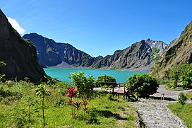


 This article incorporates text from this source, which is in the public domain.