This article needs additional citations for verification. Please help improve this article by adding citations to reliable sources. Unsourced material may be challenged and removed. Find sources: "Shivwits Plateau" – news · newspapers · books · scholar · JSTOR(August 2018) (Learn how and when to remove this message)
Shivwits Plateau
Shivwits Plateau, southeast terminus
Shivwits Plateau
Shivwits Plateau region of Arizona
Length
50 mi (80 km) NW to SE
Width
23 mi (37 km) E-W (at southeast terminus)
Geography
Country
United States
State
Arizona
Region
Grand Canyon-Parashant National Monument Grand Canyon
District
Mohave County, Arizona
Communities
Littlefield, Arizona
Peach Springs, Arizona
Borders on
Hurricane Cliffs-E Colorado River and Aubrey Cliffs-E to SE Peach Springs, Arizona-S (Sanup Plateau)-(southwest border) Colorado River and (southwest)- Hualapai Indian Reservation-SW Grand Wash Cliffs-W and NW Grand Wash Cliffs Wilderness-WNW Virgin Mountains-NNW Black Rock Mountain & Paiute Wilderness
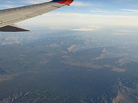
The Shivwits Plateau is a large plateau in northwest Arizona, and in the northwest of the Grand Canyon region. Just like the Kaibab Plateau in the east Grand Canyon forces the course of the Colorado River encircling it, the Shivwits Plateau is the major course changer of the Colorado in west Grand Canyon. The Colorado River goes due-south on the east perimeter of the plateau, goes west, then northwest to its outfall at Lake Mead. The southwest of the plateau borders the Colorado, but a lower elevation section is directly riverside; it is lower elevation hills and small canyons, called Sanup Plateau, and bordering the section of the Colorado called the Lower Granite Gorge. (The Lower Granite Gorge starts on the east side at the start of its due-south excursion around Shivwits Plateau.)
(forested)-Shivwits Plateau, (center-left)
The Shivwits Plateau is named for the Shivwits section of the Paiute Indian tribes. The plateau is also one of the major areas of the Grand Canyon-Parashant National Monument that is bordered by the Lake Mead National Recreation Area (west), the Hualapai Indian Reservation (southeast), and Grand Canyon National Park (east).
^U.S. Geological Survey Geographic Names Information System: Shivwits Plateau
The ShivwitsPlateau is a large plateau in northwest Arizona, and in the northwest of the Grand Canyon region. Just like the Kaibab Plateau in the east...
The Shivwits Band of Paiutes is a sovereign, federally recognized tribe located in southwestern Utah. The Shivwits Band is one of five Bands comprising...
Lake Mead National Recreation Area in 1947, and Lake Mohave and the ShivwitsPlateau were later added to its jurisdiction. Both lakes and the surrounding...
(Arizona) San Simon Valley Santa Rosa Valley Sentinel Plain ShivwitsPlateau Shonto Plateau Sonoran Desert Sonsela Butte Sulphur Springs Valley Sycamore...
132.0 km2) Located on the northern rim of the Grand Canyon on the ShivwitsPlateau, this diverse landscape includes geologic resources including millennia...
Canyon-Parashant National Monument in northwest Arizona west of the ShivwitsPlateau south through the Grand Cliffs Wilderness and into the Lake Mead Recreation...
dispute their fate, but it is often proposed that they were killed by local Shivwits Indians in a case of mistaken identity. Another story suggests that they...
000-foot (2,700 m)-high Kaibab Uplift and passes seven plateaus (the Kaibab, Kanab, and Shivwitsplateaus bound the northern part of the canyon and the Coconino...
Amoroso, L. (1 October 2004). "Paleoseismology and Neotectonics of the Shivwits Section of the Hurricane Fault, Northwestern Arizona". Bulletin of the...
Canyon region to about 900 feet (270 m) in the region of Toroweap and ShivwitsPlateaus. In the Sedona, Arizona area, it averages 300 feet (91 m) in thickness...
three men traveled was marked by tensions between farming and hunting Shivwits and incoming Mormon settlers. Which group was responsible for killing the...
of the north massif contains Shivwits, Utah in the center of a section of the Paiute Indian Tribe of Utah, the Shivwits Band of Utah. Utah highway 91...
removed: Local derivation indicated by ca. 5.4 Ma fluvial deposits below ShivwitsPlateau basalts north of Grand Canyon". Geosphere. 17 (6): 1704–1714. Bibcode:2021Geosp...
western United States that straddles the intersection of the Colorado Plateau, the Great Basin, and the Rocky Mountains, has been the traditional home...
Las Vegas, Pahrump, and Moapa, in Nevada; Cedar City, Kanosh, Koosharem, Shivwits, and Indian Peaks, in Utah; at Kaibab and Willow Springs, in Arizona. Prior...
Moapa, southern Nevada Panaca Panguitch, Utah Paranigets, southern Nevada Shivwits, southwestern Utah Coso People, of Coso Rock Art District in the Coso Range...
three disappeared; some historians have speculated they were killed by the Shivwits Band of Paiutes or by Mormons in the town of Toquerville. Powell retraced...
were reportedly killed by Shivwits band Paiutes who thought they were miners that recently molested and killed a female Shivwit. All those who stayed with...
states that Hamblin originally purchased Eliza, a Paiute from Utah of the Shivwit or Cedar Band, to free her from slavery. Hamblin adopted Eliza when she...
conflicting reports as to whether they had been killed by members of the Shivwits tribe who mistakenly thought that they were some miners who had recently...
 Global Information