September 30, 1935; 88 years ago (1935-09-30) by the Hoover Dam
Max. length
120 mi (190 km)
Surface area
247 sq mi (640 km2)
Max. depth
532 ft (162 m)
Water volume
Maximum: 26,134,000 acre⋅ft (32.236 km3)
Shore length1
759 mi (1,221 km)
Surface elevation
Maximum: 1,229 ft (375 m)
Website
Lake Mead National Recreation Area
1 Shore length is not a well-defined measure.
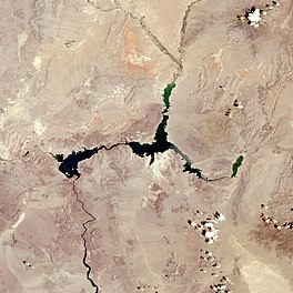
Lake Mead is a reservoir formed by the Hoover Dam on the Colorado River in the Southwestern United States. It is located in the states of Nevada and Arizona, 24 mi (39 km) east of Las Vegas. It is the largest reservoir in the US in terms of water capacity. Lake Mead provides water to the states of Arizona, California, and Nevada as well as some of Mexico, providing sustenance to nearly 20 million people and large areas of farmland.[1]
At maximum capacity, Lake Mead is 112 miles (180 km) long, 532 feet (162 m) at its greatest depth, has a surface elevation of 1,229 feet (375 m) above sea level, has a surface area of 247 square miles (640 km2), and contains 28.23 million acre-feet (34.82 km3) of water.
The lake has remained below full capacity since 1983 owing to drought and increased water demand.[2][3][4] As of May 31, 2022, Lake Mead held 26.63% of full capacity at 7.517 million acre-feet (9,272,000 megaliters), having dropped in June 2021 below the reservoir's previous all-time low of 9.328 million acre-feet (11,506,000 megaliters) recorded in July 2016, and never returning to that level.[5] In a draft 2022 Colorado River annual operating plan, released by the U.S. Bureau of Reclamation, a "Shortage Condition" was expected to be declared for 2022, due to the lake level falling below 1,075 feet (327.7 m), which would have resulted in a projected 4.44% curtailment in downstream water delivery.[6]
^"Drought: Lake Mead is at an Historic Low". Ecowatch. April 28, 2015. Archived from the original on September 25, 2015.
^USGS Circular 1381: A Synthesis of Aquatic Science for Management of Lakes Mead and Mohave. 2012. p. 11. Archived from the original on August 14, 2013.
^Bureau of Reclamation, Lower Colorado Region, Hoover Dam Web Designer. "Bureau of Reclamation: Lower Colorado Region – Hoover Dam: Lake Mead FAQs". Usbr.gov. Archived from the original on May 20, 2012. Retrieved December 13, 2014.{{cite web}}: CS1 maint: multiple names: authors list (link)
^Ferrari, Ronald L. (February 2008). "2001 Lake Mead Sedimentation Survey" (PDF). U.S. Bureau of Reclamation. Archived from the original (PDF) on September 21, 2012. Retrieved February 26, 2012.
^"Lake Mead Water Database". lakemead.water-data.com. Retrieved June 10, 2021.
^"DRAFT Annual Operating Plan for Colorado River Reservoirs 2022" (PDF). U.S. Bureau of Reclamation. May 27, 2021. pp. 32–33. Retrieved June 3, 2021. Based on a projected January 1, 2022 Lake Mead elevation of 1,067.24 feet (325.29 meters) and consistent with Section 2.D.1 of the 2007 Interim Guidelines, a Shortage Condition, consistent with Section 2.D.1.a, will govern releases for use in the states of Arizona, Nevada, and California during calendar year 2022....
LakeMead is a reservoir formed by the Hoover Dam on the Colorado River in the Southwestern United States. It is located in the states of Nevada and Arizona...
LakeMead National Recreation Area is a U.S. national recreation area in southeastern Nevada and northwestern Arizona. Operated by the National Park Service...
allowing flood waters to be diverted under the reservoir into LakeMead with the rest absorbed by Lake Las Vegas itself. After falling into substantial disrepair...
water when full, second in the United States to only LakeMead - though LakeMead has fallen below Lake Powell in size several times during the 21st century...
across the Colorado Plateau and through the Grand Canyon before reaching LakeMead on the Arizona–Nevada border, where it turns south toward the international...
1968 with F-111s, and the TFW was fully operational in July 1971. The LakeMead Base, a 1953–6 United States Navy's weapons storage area of 2,832 ha (6...
retained in both Lake Powell and LakeMead, in order to preserve hydro-power generation capacity at both lakes. This resulted in LakeMead declining to the...
March 1, 1936, more than two years ahead of schedule. Hoover Dam impounds LakeMead and is located near Boulder City, Nevada, a municipality originally constructed...
signed as LakeMead Boulevard and runs from Interstate 15 (I-15) and U.S. Route 93 (US 93) in North Las Vegas east to the border of the LakeMead National...
Theodore Roosevelt is the largest lake or reservoir located entirely within the state of Arizona (LakeMead and Lake Powell are larger but are both located...
Pearce Ferry, LakeMead, is the first take-out point for river trips traveling through the entire Grand Canyon. This Take-Out (on LakeMead) has been recently...
and proceeded to LakeMead to conduct qualifying tests in the S-43. The test flight did not go well. The Sikorsky crashed into LakeMead, killing CAA inspector...
647 feet (197 m), Lake Mohave encompasses 28,260 acres (114.4 km2) of water. As LakeMead lies to the north of the Hoover Dam, Lake Mohave and adjacent...
The megadrought has prompted the declaration of a water shortage at LakeMead, the largest reservoir in the United States. Climate change models project...
turns south near Las Vegas, Nevada, forming the Arizona–Nevada border in LakeMead and the Arizona–California border a few miles below Davis Dam between...
Arizona. Lake Havasu City sits on the Arizonan side of the lake with its Californian counterpart of Havasu Lake directly across the lake. The reservoir...
superintendent of the LakeMead National Recreation Area from 1987 through 2000, is a retired National Park Service official whose tenure at LakeMead included the...
routes include Blue Diamond Road (SR 160) to Pahrump and LakeMead Boulevard (SR 147) to LakeMead. East–west roads, north to south Ann Road Craig Road (SR...
 Global Information