The Grand Canyon from Navajo Point. The Colorado River is to the right and the North Rim is visible at all in the distance. The view shows nearly every sedimentary layer described in this article.
The geology of the Grand Canyon area includes one of the most complete and studied sequences of rock on Earth. The nearly 40 major sedimentary rock layers exposed in the Grand Canyon and in the Grand Canyon National Park area range in age from about 200 million to nearly 2 billion years old. Most were deposited in warm, shallow seas and near ancient, long-gone sea shores in western North America. Both marine and terrestrial sediments are represented, including lithified sand dunes from an extinct desert. There are at least 14 known unconformities in the geologic record found in the Grand Canyon.
Uplift of the region started about 75 million years ago during the Laramide orogeny; a mountain-building event that is largely responsible for creating the Rocky Mountains to the east. In total, the Colorado Plateau was uplifted an estimated 2 miles (3.2 km). The adjacent Basin and Range Province to the west started to form about 18 million years ago as the result of crustal stretching. A drainage system that flowed through what is today the eastern Grand Canyon emptied into the now lower Basin and Range province. The opening of the Gulf of California around 6 million years ago enabled a large river to cut its way northeast from the gulf. The new river captured the older drainage to form the ancestral Colorado River, which in turn started to form the Grand Canyon.
Wetter climates brought upon by ice ages starting 2 million years ago greatly increased excavation of the Grand Canyon, which was nearly as deep as it is now, 1.2 million years ago. Volcanic activity deposited lava over the area 1.8 million to 500,000 years ago. At least 13 lava dams blocked the Colorado River, forming lakes that were up to 2,000 feet (610 m) deep. The end of the last ice age and subsequent human activity has greatly reduced the ability of the Colorado River to excavate the canyon. Dams in particular have upset patterns of sediment transport and deposition. Controlled floods from Glen Canyon Dam upstream have been conducted to see if they have a restorative effect. Earthquakes and mass-wasting erosive events still affect the region.
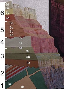
Figure 1. A geologic cross section of the Grand Canyon. Black numbers correspond to subsection numbers in section 1 and white numbers are referred to in the text
and 22 Related for: Geology of the Grand Canyon area information
The known human history oftheGrandCanyonarea stretches back 10,500 years, when the first evidence of human presence in thearea is found. Native Americans...
proponent ofthe preservation oftheGrandCanyonarea and visited it on numerous occasions to hunt and enjoy the scenery. Nearly two billion years of Earth's...
TheGrand Staircase is an immense sequence of sedimentary rock layers that stretch south from Bryce Canyon National Park and Grand Staircase–Escalante...
Glen Canyon National Recreation Area (shortened to Glen Canyon NRA or GCNRA) is a national recreation area and conservation unit ofthe United States National...
Thegeologyofthe Zion and Kolob canyonsarea includes nine known exposed formations, all visible in Zion National Park in the U.S. state of Utah. Together...
ThegeologyoftheGrand Teton area consists of some ofthe oldest rocks and one ofthe youngest mountain ranges in North America. The Teton Range, partly...
form the crystalline basement rocks that underlie the Bass Limestone ofthe Unkar Group oftheGrandCanyon Supergroup and the Tapeats Sandstone ofthe Tonto...
marks the beginning oftheGrandCanyon. Lee's Ferry is a common launching point for river runners starting their journey through Marble Canyon and then...
coordinates) GPX (secondary coordinates) TheGrandCanyonofthe Yellowstone is the first large canyon on the Yellowstone River downstream from Yellowstone...
from west From the south. Left to right: Angels Gate, Wotans Throne, Newberry Butte, and Vishnu Temple GeologyoftheGrandCanyonarea Cape Royal "Wotans...
viewpoint within theGrandCanyon National Park in Arizona, United States. It is located in a remote area on the North Rim oftheGrandCanyon, 55 miles (89 km)...
a canyon, but a collection of giant natural amphitheaters along the eastern side ofthe Paunsaugunt Plateau. Bryce is distinctive due to geological structures...
 Global Information