U.S. Bureau of Reclamation and California Department of Water Resources
Dam and spillways
Type of dam
Embankment
Height (foundation)
382 ft (116 m)[2]
Length
18,600 ft (5,700 m)[2]
Dam volume
77,656,000 cu yd (59,372,000 m3)[3]
Reservoir
Creates
San Luis Reservoir
Total capacity
2,041,000 acre⋅ft (2.518 km3)[3]
Catchment area
82.6 sq mi (214 km2)[2]
Surface area
12,700 acres (5,100 ha)
Normal elevation
544 ft (166 m)[2]
William R. Gianelli Powerplant[4]
Commission date
1968[4]
Type
Pumping-generating
Hydraulic head
323 ft (98 m) max[4]
Turbines
8 x 53.0 MW Francis turbines[4]
Installed capacity
424 MW[4]
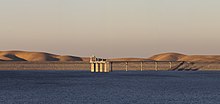
San Luis Dam, also known as B.F. Sisk Dam, is a major earth-filled dam in Merced County, California, which forms San Luis Reservoir, the largest off-stream reservoir in the United States.[citation needed] The dam and reservoir are located in the Diablo Range to the east of Pacheco Pass and about 10 miles (16 km) west of Los Banos. San Luis Dam, a jointly-owned state and federal facility, stores more than 2 million acre feet (2.5 km3) of water for the California State Water Project and the federal Central Valley Project. Although the dam is located in the valley of San Luis Creek, the majority of its water comes from man-made aqueducts which are supplied from other rivers in Northern California.
San Luis provides water mainly for irrigation in the San Joaquin Valley, where it augments the supply for more than 1 million acres (400,000 ha) of agricultural land, although some water is also used for urban and environmental uses. The dam was built between 1963 and 1968, and filled for the first time in 1969. It provides flexibility to the state water system by capturing, via pumps and canals, the wet season (November–April) runoff that would otherwise flow from the Sacramento–San Joaquin River Delta into the Pacific Ocean. It also generates hydroelectricity by releasing the water when it is needed. However, it has indirectly impacted the environment by enabling increased water diversion from sensitive estuary regions. In recent years, a combination of drought and pumping restrictions enacted to protect endangered fish have contributed to low water levels at the San Luis Reservoir.[5]
The dam and reservoir are visible from the Romero Overlook Visitors Center, which is located along Highway 152.[6]
^"San Luis Dam". Geographic Names Information System. United States Geological Survey, United States Department of the Interior. January 19, 1981. Retrieved February 9, 2017.
^ abcdCite error: The named reference San Luis Dam was invoked but never defined (see the help page).
^ abCite error: The named reference San Luis Unit Project was invoked but never defined (see the help page).
^ abcdeCite error: The named reference Gianelli Powerplant was invoked but never defined (see the help page).
^Rogers, Paul (August 16, 2013). "San Luis Reservoir 17 percent full, causing Silicon Valley water problems". The Mercury News. Retrieved February 9, 2017.
^"Locations: Romero Overlook Visitors Center (San Luis Reservoir)". California Department of Water Resources. Retrieved February 10, 2017.
SanLuisDam, also known as B.F. Sisk Dam, is a major earth-filled dam in Merced County, California, which forms SanLuis Reservoir, the largest off-stream...
related to SanLuis Reservoir. SanLuisDamSanLuis Reservoir from Romero Outlook SanLuisDam and Gianelli Powerhouse Satellite photo of SanLuisDam and the...
man-made dams by volume of fill/structure. By general definition, a dam is a barrier that impounds water or underground streams, hence tailings dams are relegated...
Gianelli Power Plant. Gianelli is located at the base of SanLuisDam, which forms SanLuis Reservoir, the largest offstream reservoir in the United States...
embankment dam completed in 1968. Five of the ten tallest dams in the U.S. are located in California. The Colorado, Columbia and Sacramento–San Joaquin river...
Salinas Dam, which forms Santa Margarita Lake, was built to supply water to Camp SanLuis Obispo. The lake now supplies water to the city of SanLuis Obispo...
with Susan and her younger brother Steven. When he found work on the SanLuisDam construction project, Edward left the two children behind to fend for...
The Salinas Dam is a dam built on the Salinas River in SanLuis Obispo County, California. Designed by Raymond A. Hill, the gravity dam features an arched...
9, 1971, in 1971 San Fernando earthquake Ah Pah Dam (defunct) Auburn Dam (defunct) Centennial Dam Sites Reservoir Temperance Flat Dam California State...
than one main dam holding it back (e.g. Diamond Valley Lake), the name of the highest one will be given (in this case, the West Dam). SanLuis Reservoir receives...
its shape. Although located in SanLuis Obispo County, the Nacimiento Dam and nearby San Antonio Dam, which forms Lake San Antonio, are both owned and operated...
Plant, also known as the SanLuis Power Plant, is a pumped-storage hydroelectric plant that is at the base of the SanLuisDam in California. During the...
Lake Henshaw, a reservoir formed by a dam across the main stem SanLuis Rey River. From the base of Henshaw Dam, the river winds west along the foot of...
Hydroelectric Dam (Spanish: Central Hidroeléctrica 3 de Febrero), also known as El Chaparral, is a dam and hydroelectric power plant located in SanLuis de la...
Project: Oroville Dam. The DWR and the United States Bureau of Reclamation also signed an agreement to design a joint reservoir in SanLuis. Because water...
2010. "B.F. Sisk Dam". SanLuis Unit. U.S. Bureau of Reclamation. August 31, 2009. Retrieved January 16, 2010. "O'Neill Dam". SanLuis Unit. U.S. Bureau...
River in northern SanLuis Obispo County, California. The lake contains many arms including Snake Creek and Dip Creek, nearer the dam, and the central...
SanLuis Obispo Creek is a stream, about 18 miles (29 km) long, in SanLuis Obispo County, California. It drains a large coastal watershed that includes...
Querétaro, Hidalgo, SanLuis Potosí and Veracruz. The water level of the Zimapán dam was affected by the overflow of the Río San Juan in Querétaro, which...
and create a storm sewer. Work began on the Olmos Dam and bypass channel in 1926; however, the San Antonio Conservation Society successfully protested...
of water - the O'Neill Forebay of the massive SanLuis Reservoir (just to the east of the SanLuisDam) on several artificial islands. The lone southwestward...
Pacheco Conduit and Hollister Conduit fed by the SanLuis Reservoir. Completed in January 1986, the dam is an earthfill structure 151 feet (46 m) high....
source of the SanLuis Rey River. The lake was constructed in 1923 (101 years ago) (1923) with the building of Henshaw Dam, an earth dam 123 feet (37 m)...
reservoir near the city of Arroyo Grande in SanLuis Obispo County, California. The lake is formed by Lopez Dam on Arroyo Grande Creek, 9 mi (14 km) upstream...
 Global Information