The San Luis Rey River is a river in northern San Diego County, California.
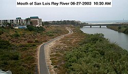
The river's headwaters are in the Palomar Mountain Range and Cleveland National Forest, near Palomar Mountain and the Santa Rosa Mountains. The river mouth, on the Pacific Ocean, is in northern Oceanside. The San Luis Rey River bike path runs along it for its last 9 miles (14 km).
The river is over 69 miles (111 km) long[4] and drains 562 square miles (1,460 km2). There is little water in the river during most of the year, but it can have very large flows during winter storms.
^ ab"San Luis Rey River". Geographic Names Information System. United States Geological Survey, United States Department of the Interior. 1981-01-19. Retrieved 2010-09-12.
^Length measured in Google Earth using path measure tool; measured to longest source (includes Fry Creek and West Fork San Luis Rey River
^ abc"Water-Data Report 2009: USGS Gage #11042000 on the San Luis Rey River at Oceanside, CA" (PDF). National Water Information System. U.S. Geological Survey. 1930–2009. Retrieved 2010-09-12.
^U.S. Geological Survey. National Hydrography Dataset high-resolution flowline data. The National Map, accessed March 16, 2011
and 21 Related for: San Luis Rey River information
The SanLuisReyRiver is a river in northern San Diego County, California. The river's headwaters are in the Palomar Mountain Range and Cleveland National...
Mission SanLuisRey de Francia (Spanish: Misión SanLuisRey de Francia) is a former Spanish mission in SanLuisRey, a neighborhood of Oceanside, California...
The Bridge of SanLuisRey is American author Thornton Wilder's second novel. It was first published in 1927 to worldwide acclaim. The novel won the Pulitzer...
Chronologically, two phases of the complex were proposed. SanLuisRey I was distinguished from SanLuisRey II primarily by the appearance of pottery in the latter...
Canyon SanLuisReyRiver West Fork SanLuisReyRiverSan Dieguito River Santa Maria Creek (San Diego) Santa Ysabel Creek Temescal Creek (San Diego) San Diego...
some twenty miles inland upstream from the latter mission on the SanLuisReyRiver. Pala Mission was part of the Spanish missions, asistencias, and estancias...
the SanLuisRey Valley to Fallbrook date from June 1889, and included a bridge over the SanLuisReyRiver. Construction on the bridge over the river at...
The Pala Indian Reservation is located in the middle of SanLuisReyRiver Valley in northern San Diego County, California, east of the community of Fallbrook...
Oceanside, a city in San Diego County, California, United States. It is located between California State Route 76 and the SanLuisReyRiver bike path. The...
olsoni (SanLuisReyRiver Late Miocene—Early Pliocene of W USA) Cepphus cf. columba (Lawrence Canyon Early Pliocene of W USA) Cepphus cf. grylle (San Diego...
area of 207 square miles (540 km2) square miles at the source of the SanLuisReyRiver. The lake was constructed in 1923 (101 years ago) (1923) with the...
"frog pond" or waxáawu-may "little frog". The grant was south of SanLuisReyRiver and Rancho Monserate and north of present-day Vista. The site is now...
led them further along the coast and up the Colorado River. However, to reach the SanLuisReyRiver overland travel would have been necessary with permanent...
coast. Pauma Complex sites have been identified primarily in the SanLuisReyRiver valley and on the Valley Center plateau to the south of it. Archaeological...
on the Santa Margarita River to 800 m (2,640 ft) at the South Fork Kern River and 910 m (3,000 ft) at upper SanLuisReyRiver in California and to over...
County) San Jacinto Mountains (Riverside County) San Jacinto River (Riverside County) San Joaquin Valley (Kern County) SanLuisReyRiver (San Diego County)...
Major rivers in the region include the Los Angeles River, San Gabriel River, San Diego River, SanLuisReyRiver, Santa Ana River, Santa Clara River, Santa...
 Global Information