U.S. Bureau of Reclamation and California Department of Water Resources
Surface area
12,700 acres (5,100 ha)
Water volume
2,041,000 acre-feet (2,518,000 dam3)
Surface elevation
544 ft (166 m)
References
U.S. Geological Survey Geographic Names Information System: San Luis Reservoir
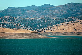
The reservoir in 2002Panoramic view of the reservoir
The San Luis Reservoir is an artificial lake on San Luis Creek in the eastern slopes of the Diablo Range of Merced County, California, approximately 12 mi (19 km) west of Los Banos on State Route 152, which crosses Pacheco Pass and runs along its north shore. It is the fifth largest reservoir in California. The reservoir stores water taken from the San Joaquin-Sacramento River Delta. Water is pumped uphill into the reservoir from the O'Neill Forebay which is fed by the California Aqueduct and is released back into the forebay to continue downstream along the aqueduct as needed for farm irrigation and other uses. Depending on water levels, the reservoir is approximately nine miles (14 km) long from north to south at its longest point, and five miles (8 km) wide. At the eastern end of the reservoir is the San Luis Dam, the fourth largest embankment dam in the United States, which allows for a total capacity of 2,041,000 acre-feet (2,518,000 dam3). Pacheco State Park lies along its western shores.
Completed in 1967 on land formerly part of Rancho San Luis Gonzaga, the 12,700 acres (5,100 ha) reservoir is a joint use facility, being a part of both the California State Water Project and federal Central Valley Project, which together form a network of reservoirs, dams, pumping stations, and 550 miles (885 km) of canals and major conduits to move water across California.[1] The San Luis Reservoir is located in Merced County, and has a visitor center located at the Romero Outlook where visitors can learn more about the dam and reservoir. The surface of the reservoir lies at an elevation of approximately 544 ft (166 m), with the O'Neill Forebay below the dam at 225 ft (69 m) above sea level. This elevation difference allows for a hydroelectric plant to be constructed - the Gianelli Hydroelectric Plant. Power from this plant is sent to a Path 15 substation, Los Banos via a short power line. Those 500 kV wires, carrying both the power generated here and elsewhere, leave the area and cross the O'Neill Forebay on several man-made islands.
San Luis Reservoir also supplies water to 63,500 acres (25,700 ha) of land in the Santa Clara Valley west of the Coast Ranges.[2] San Justo Dam stores water diverted from San Luis Reservoir through the Pacheco Tunnel and Hollister Conduit, which travel through the Diablo Range.[3] The Santa Clara Tunnel and Santa Clara Conduit convey water to the Coyote Pumping Station in the Santa Clara Valley.[2][4]
^San Luis Unit Project. Central Valley Project (Report). U.S. Bureau of Reclamation. April 21, 2011. Archived from the original on November 12, 2011.
^ ab"San Felipe Division". Central Valley Project. U.S. Bureau of Reclamation. June 17, 2009. Retrieved December 28, 2016.
^"San Justo Dam". San Felipe Unit. U.S. Bureau of Reclamation. May 13, 2009. Retrieved December 28, 2016.
^"Failure of key water pipeline into Silicon Valley may have exposed wider problems". mercurynews.com. March 1, 2016. Retrieved April 2, 2018.
and 23 Related for: San Luis Reservoir information
The SanLuisReservoir is an artificial lake on SanLuis Creek in the eastern slopes of the Diablo Range of Merced County, California, approximately 12 mi...
SanLuis Dam, also known as B.F. Sisk Dam, is a major earth-filled dam in Merced County, California, which forms SanLuisReservoir, the largest off-stream...
Gianelli is located at the base of SanLuis Dam, which forms SanLuisReservoir, the largest offstream reservoir in the United States. The Castaic Power...
name of the highest one will be given (in this case, the West Dam). SanLuisReservoir receives most of its water from the California Aqueduct. Diamond Valley...
Sacramento River upstream of the Sacramento–San Joaquin River Delta, through existing canals to a new reservoir 14 miles (23 km) away. Annual yield would...
04 million acre-feet (2.52 km3) of storage available in SanLuisReservoir. South of the SanLuisReservoir complex, the aqueduct steadily gains elevation through...
flows through California it goes through many reservoirs such as SanLuisReservoir. From the SanLuisReservoir to the O'Neill Forebay, the water flows down...
lies the SanLuisReservoir, which stores water for the Central Valley Project and the California State Water Project. The SanLuisReservoir and O'Neill...
the northern and eastern shore of the massive SanLuisReservoir. The route passes in between the SanLuis Dam and the O'Neill Forebay. The route continues...
The park contains approximately 3,200 lakes (greater than 100 m2), two reservoirs, and 1,700 miles (2,700 km) of streams. Wetlands flourish in valley bottoms...
Bureau of Reclamation also signed an agreement to design a joint reservoir in SanLuis. Because water from the Oroville and Shasta dams (from the existing...
Squatriglia, Chuck (September 24, 2006). "Magical underground world". sfgate.com. San Francisco Chronicle. Archived from the original on November 3, 2007. Retrieved...
century, in 1978, ten tule elk were reintroduced to Point Reyes from the SanLuis National Wildlife Refuge near Los Banos. By 2009, the population climbed...
property was condemned by the state of California in 1962 to create the SanLuisReservoir, and the original 1846 ranch house, which she had restored, was destroyed...
hypothetical donation to this imaginary museum. The 2004 game Grand Theft Auto: San Andreas features the Jefferson Towers (also named as Sculpture Park) in the...
Whale Rock Reservoir is a reservoir near Cayucos in SanLuis Obispo County, California. The reservoir was formed by the building of Whale Rock Dam on Old...
Coyote Ridge in Santa Clara Valley, San Jose, California and in Pacheco State Park and areas surrounding SanLuisReservoir near Los Banos, California. Considered...
Putah Creek Rector Reservoir Red Lake Rhode Island Sacramento River San Felipe Valley San Jacinto SanLuis Obispo SanLuisReservoirSan Pablo Bay Santa...
the Northern California coastal region. Smith and nineteen companions left San Jose, California, and explored what are now called the Trinity, Smith, and...
 Global Information