Structural basin in the Southwestern United States
For the San Juan River Watershed, see San Juan River.
The San Juan structural basin is primarily in New Mexico and the southeast corner of the Colorado Plateau.The San Juan structural basin is generally the east portion of the San Juan River Watershed of 24,600 sq mi (64,000 km2) which extends farther west into Utah and Arizona.[1]
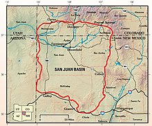
The San Juan Basin is a geologic structural basin located near the Four Corners region of the Southwestern United States. The basin covers 7,500 square miles and resides in northwestern New Mexico, southwestern Colorado, and parts of Utah and Arizona. Specifically, the basin occupies space in the San Juan, Rio Arriba, Sandoval, and McKinley counties in New Mexico, and La Plata and Archuleta counties in Colorado. The basin extends roughly 100 miles (160 km) N-S and 90 miles (140 km) E-W.[2]
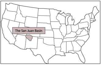
Location of the San Juan Basin on a map of the United States.
The San Juan Basin is an asymmetric structural depression in the Colorado Plateau province, with varying elevation and nearly 3,000 feet (910 m) in topographic relief. Its most striking features include Chaco Canyon (northwestern New Mexico, between Farmington and Santa Fe) and Chacra Mesa. The basin lies west of the Continental Divide, and its main drainage is the southwest- to west-flowing San Juan River, which eventually joins the Colorado River in Utah. Climate of the basin is arid to semiarid, with an annual precipitation of 15 in (380 mm) and an average annual temperature of around 50 °F (10 °C).[2]
The San Juan Basin has been a major producer of oil and natural gas since the early 20th century, with currently more than 300 oil fields and over 40,000 drilled wells throughout the area. As of 2009, cumulative production reached 42.6 trillion cubic feet of gas and 381 million barrels of oil. The area is especially known for gas reservoirs from its coal-bed methane formations. The San Juan Basin contains the largest coal-bed methane field in the world and ranks second in total gas reserves.[2][3]
^"Boundary Descriptions and Names of Regions, Subregions, Accounting Units and Cataloging Units". U.S. Geological Survey. Retrieved December 27, 2010.
^ abcFassett, James E.; Hinds, Jim S. (1971). "Geology and fuel resources of the Fruitland Formation and Kirtland Shale of the San Juan Basin, New Mexico and Colorado". Geological Survey Professional Paper. Professional Paper. 676. doi:10.3133/pp676.
^Fassett, James E. (2010). "Oil and gas resources of the San Juan Basin, New Mexico and Colorado" (PDF). New Mexico Geological Society Guidebook. 61st Field Conference: 181–196. Retrieved November 12, 2020.
The SanJuanBasin is a geologic structural basin located near the Four Corners region of the Southwestern United States. The basin covers 7,500 square...
the SanJuanBasin methane leak or New Mexico methane source or various related permutations) refers to a clustering of large methane sources near San Juan...
SanJuan Creek, also called the SanJuan River, is a 29-mile (47 km) long stream in Orange and Riverside Counties, draining a watershed of 133.9 square...
by Barnum Brown in 1910 for exposures near Ojo Alamo springs in the SanJuanBasin. Baltz et al. reassigned the lower beds to the Kirtland Formation in...
Cretaceous period. It overlies the Fruitland Formation. It is found in the SanJuanBasin in the states of New Mexico and Colorado, in the United States of America...
California SanJuanBasin, New Mexico and Colorado Uinta Basin, Utah Williston Basin, Montana and North Dakota Wind River Basin, Wyoming Amadeus Basin Bowen...
its remains having been mostly found in the Kirtland Formation in the SanJuanBasin in New Mexico. About a dozen skulls and skeletons have been uncovered...
the Brushy Basin Member and the Upper Part of the Westwater Canyon Member of the Morrison Formation, SanJuanBasin, New Mexico," in A Basin Analysis Case...
purchased the 220-mile pipeline gathering system owned by WPX Energy in the SanJuanBasin in New Mexico. The purchase price was reported to be US$285 million...
from the Fruitland-Kirtland transition (Kirtlandian, late Campanian), SanJuanBasin, New Mexico, with a description of a new species of Stegoceras and a...
hot springs (Ute: Pah gosah) is a hot spring system located in the SanJuanBasin of Archuleta County, Colorado. The town of Pagosa Springs claim they...
colleagues reported the discovery of a single hadrosaur right femur in the SanJuanBasin of New Mexico, and described it as evidence of Paleocene dinosaurs....
they were influenced by surrounding areas, including the Great Basin, the SanJuanBasin, and the Rio Grande Valley. Later, Archaic people established...
towns. —Cochiti origin myth During the 10th to 8th millennia BCE, the SanJuanBasin was occupied by Paleo-Indians known as the Clovis culture (c. 9,300)...
The Fruitland Formation is a geologic formation found in the SanJuanBasin in the states of New Mexico and Colorado, in the United States of America....
Compelling new evidence for Paleocene dinosaurs in the Ojo Alamo Sandstone SanJuanBasin, New Mexico and Colorado, USA (PDF). International Conference on Catastrophic...
recycling in 2020. In December 2018, the company sold its assets in the SanJuanBasin for $480 million. In February 2019, the company acquired Newfield Exploration...
that cannibalism was present in various tyrannosaurid genera of the SanJuanBasin. The evidence gathered from the specimens suggests opportunistic feeding...
of Colorado have some land in the Rio Grande Basin including Archuleta County, Hinsdale County and SanJuan County. Blanca Peak is prominent in the Sierra...
dated 40,000 years after the boundary, and a hadrosaur femur from the SanJuanBasin dated to 64.5 mya, but such stray late forms may be zombie taxa that...
Paleocene multituberculates from the SanJuanBasin, New Mexico", p. 127-160, in Lucas et al. (eds), Advances in SanJuanBasin paleontology. University of New...
 Global Information