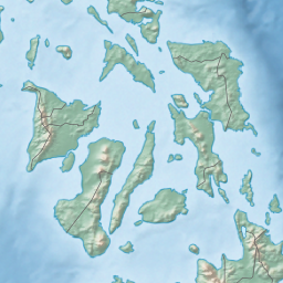
The Samar Sea is a small sea within the Philippine archipelago, situated between the Bicol Region of Luzon and the Eastern Visayas.[1]
It is bordered by the islands of Samar to the east, Leyte to the south, Masbate to the west, and Luzon to the north. The sea is connected to the Philippine Sea to the north via San Bernardino Strait, to Leyte Gulf to the southeast via San Juanico Strait, to the Visayan Sea to the southwest, and to the Sibuyan Sea to the northwest via Masbate Pass and Ticao Pass. It contains Biliran Island, the islands of Almagro, Maripipi, Sto. Nino, Daram, and Tagapul-an.
The Samar Sea has experienced a significant degradation of marine resources, that is even characterized as "ecocide". Before 1981, there were 50 commercial fish species, but within 10 years, it was reduced to only 10 due to overfishing and destructive fishing methods (like dynamite fishing). Average daily catch has reduced from 30 kg/day in the 1960s, to 8 kg/day in 1981, to 3.5 kg/day in 1991. Having depleted the large predatory fish, fishermen turned to smaller species, allowing jellyfish populations to explode.[2]
Deforestation of surrounding lands has led to increased silt from denuded mountains that choke coral reefs. Only some 5% of reefs are considered to be in a healthy condition. Another result of the increased silt are red tides, causing paralytic shellfish poisonings. The first red tide in the Philippines occurred in the Samar Sea in 1983 and thereafter continued to occur at irregular intervals.[2]
^"Samar Sea: Philippines". Geographic.org. Retrieved 22 July 2013.
^ abJ. Saeger (1993). "The Samar Sea, Philippines: a decade of devastation". Naga, the ICLARM Quarterly. 16 (4): 4–6. ISSN 0116-290X. Retrieved 25 September 2023.
The SamarSea is a small sea within the Philippine archipelago, situated between the Bicol Region of Luzon and the Eastern Visayas. It is bordered by the...
Samar (/ˈsɑːmɑːr/ SAH-mar) is the third-largest and seventh-most populous island in the Philippines, with a total population of 1,909,537 as of the 2020...
Northern Samar (Waray: Amihanan Samar/Norte san Samar; Tagalog: Hilagang Samar), officially the Province of Northern Samar, is a province in the Philippines...
Eastern Samar (Waray-Waray: Sinirangan Samar; Tagalog: Silangang Samar), officially the Province of Eastern Samar, is a province in the Philippines located...
purposes: cruises, fishing, local delivery, and marinas. The South China Sea is west of the Philippines. Note: In September 2012, Philippine President...
the south. The sea is connected to several bodies of water: the Sibuyan Sea to the northwest via the Jintotolo Channel, the SamarSea to the northeast...
Philippine Sea of the Pacific Ocean, Samar to the northeast and the Dinagat Islands to the southeast forming Leyte Gulf. To the west is the Camotes Sea.[citation...
Philippines, connecting the SamarSea with the Philippine Sea. It separates the Bicol Peninsula of Luzon island from the island of Samar in the south. During...
Lungsod ng Calbayog), is a 1st class component city in the province of Samar, Philippines. According to the 2020 census, it has a population of 186,960...
faces the Philippine Sea to the east. The region's most famous landmark is the San Juanico Bridge, which links the provinces of Samar and Leyte. As of 2020...
bordered on the west by the South China Sea (Luzon Sea in Philippine territorial waters), on the east by the Philippine Sea, and on the north by the Luzon Strait...
he was released and soon after would move with Wilma to the island of Samar in the Eastern Visayas region. In later years, Tiamzon would be credited...
in the Philippines. It separates the islands of Samar and Leyte and connects Carigara Bay (SamarSea) with the San Pedro Bay (Leyte Gulf). It is about...
engagements (the Battle of the Sibuyan Sea, the Battle of Surigao Strait, the Battle off Cape Engaño, and the Battle off Samar), as well as lesser actions. Allied...
southwestern border comprises the Philippine islands of Luzon, Catanduanes, Samar, Leyte, and Mindanao. Its northern border comprises the Japanese islands...
off Samar was the centermost action of the Battle of Leyte Gulf, one of the largest naval battles in history, which took place in the Philippine Sea off...
motorboat carrying rebels of the New People's Army exploded in Catbalogan, Samar. The explosion killed the passengers including NPA leaders Benito and Wilma...
 Global Information