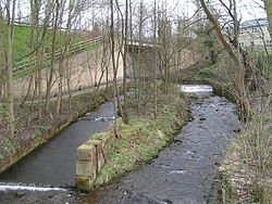
The Sett passes under the A624 Hayfield "bypass". The tower of St. Matthew's church can be seen through the trees in the background, and in the foreground are the scanty remains of Walk Mill.
The River Sett is highlighted in red Coordinates: 53°21′52″N2°00′00″W / 53.36440°N 1.99990°W / 53.36440; -1.99990
Location
Country
England
Physical characteristics
Source
• location
Kinder Scout
• elevation
c.540 metres (1,770 ft)[1]
Mouth
• location
River Goyt
• elevation
c.130 metres (430 ft)[1]
Length
16.876 kilometres (10.486 mi)
Basin size
47.143 square kilometres (18.202 sq mi)
Basin features
Tributaries
• right
River Kinder
Source of the River Sett
The River Sett is a river that flows through the High Peak borough of Derbyshire, in north western England. It rises near Edale Cross on Kinder Scout and flows through the villages of Hayfield and Birch Vale to join the River Goyt at New Mills.[1] The River Goyt is one of the principal tributaries of the River Mersey. In the past, the river was known as the River Kinder; the modern River Kinder is a right tributary of the Sett, joining the river at Bowden Bridge above Hayfield.[2]
The 2.5-mile Sett Valley Trail follows the trackbed of the former railway line along the valley between Hayfield and New Mills.[3]
The river's Environment Agency pollution classification changed from good to moderate in 2014.[4]
^ abcThe Peak District: Dark Park Area (OS Explorer Map), vol. OL1, Southampton: Ordnance Survey, 2 February 2009, ISBN 978-0-319-24067-0
^Lewis, Samuel, ed. (1848). "A Topographical Dictionary of England". pp. 394–398. Retrieved 18 April 2018. The Kinder derives its source from the mountain of Kinder-Scout, and, separating the county of Derby from that of Chester, falls into the river Guyt at a place called the Tor.
^Sett Valley Trail (leaflet produced by Derbyshire County Council Environmental Services Department)
^"Catchment Data Explorer". environment.data.gov.uk. Retrieved 14 August 2019.
The RiverSett is a river that flows through the High Peak borough of Derbyshire, in north western England. It rises near Edale Cross on Kinder Scout...
Stockport and 13 miles (21 km) from Manchester at the confluence of the River Goyt and Sett. It is close to the border with Cheshire and above the Torrs, a 70...
Kinder Scout, it flows generally westwards to its confluence with the RiverSett at Bowden Bridge (a Grade II listed packhorse bridge). En route it flows...
Brook Micker Brook Tin Brook River Tame River Goyt River Etherow RiverSettRiver Kinder List of crossings of the River Mersey "Mersey Estuary". Ramsar...
and Strutt, and were powered by the water of the River Derwent. The abundance of water from the River Etherow and its tributaries led to mills being built...
Brook (R) Chew Brook (L) River Goyt (Ls) River Etherow (R) Glossop Brook (L) Heyden Brook (R) Todd Brook (L) RiverSett (R) River Kinder (R) The Dee and...
township in the ancient parish of Glossop in England The River Kinder, a tributary of the RiverSett, Derbyshire United States Kinder, Indiana, a village...
Vale, Thornsett and Ollersett). It runs along the lower valley of the RiverSett and follows the trackbed of a former branch railway line from New Mills...
community, in New Mills, Derbyshire. It is on the River Goyt, immediately below its confluence with the RiverSett at the Torr weir. A 2.4-metre diameter steel...
streets, and buildings. Setts, also called Belgian blocks, are often inaccurately referred to as "cobbles", although a sett is distinct from a cobblestone...
branch opened, in 1868, to serve the villages along the valley of the RiverSett and the local mills. It became the joint property of the Manchester, Sheffield...
horizontally in a distinctive pattern of rectangles and lines known as a sett. Scottish tartan was originally associated with the Highlands. Early tartans...
a social, burrowing animal that sleeps during the day in one of several setts in its territorial range. These burrows have multiple chambers and entrances...
Hill, Mount Famine, South Head, Eccles Pike, Mag Low, Chinley Churn, the RiverSett and Combs Reservoir. Morris, Liz; Harvey Rudkin. "Chinley, Buxworth &...
Sheffield and Preston. The RiverSett runs below the hamlet, flowing from Kinder Scout to The Torrs in New Mills, where it joins the River Goyt. OL1 Dark Peak...
past Mount Famine and along the RiverSett into Hayfield (9.7 miles/15.6 km). 3. Hayfield to Glossop Along the Sett Valley Trail west out of Hayfield...
(psychology), a set of expectations which shapes perception or thought Set or sett, a badger's den Set, a small tuber or bulb used instead of seed, especially:...
badger colonies are more often called clans. A badger's home is called a sett. The following list shows where the various species with the common name...
settlers, such as Angles and Norse with typical suffixes such as "ton" and "sett". During medieval times, much of the upper dale was sheep country belonging...
An esplanade or promenade is a long, open, level area, usually next to a river or large body of water, where people may walk. The historical definition...
Point. The West Branch separates the village of Acoaxet (pronounced "a-KOKE-sett") from the rest of the town; one has to pass into Rhode Island in order to...
 Global Information