The Peak District Boundary Walk is a circular 190-mile (310 km) walking trail, starting and finishing at Buxton and broadly following the boundary of the Peak District, Britain's first national park. The route was developed by the Friends of the Peak District (a branch of the Campaign to Protect Rural England) and was launched on 17 June 2017.[1]
The Friends of the Peak District's founders, Gerald and Ethel Haythornthwaite, proposed the boundary of the Peak District National Park, which was subsequently established as the United Kingdom's first National Park in 1951.
Peak District Boundary Walk plaque at King's Head pub, Buxton
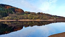
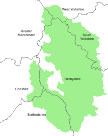
The route is waymarked with green markers and uses existing footpaths, tracks, quiet lanes, disused railway lines and a canal towpath. The start and finish is at the King's Head pub on Buxton Market Place, where a plaque has been installed by the Peak & Northern Footpaths Society (PNFS). The terrain covers open moorlands of the South Pennines, the limestone scenery of the Derbyshire Dales, woodlands, reservoirs and rural farming countryside. Most of the trail is in Derbyshire but also goes through sections of Staffordshire, Cheshire and Yorkshire. The total ascent is 7,590 metres (24,900 ft) with a highest point of 506 metres (1,660 ft) at the summit of Shutlingsloe.[2]
Peak District National ParkPeak District Boundary Walk MarkerShutlingsloe - highest point of walk at 506m
There is an official guide to the trail written by Andrew McCloy.[3]
In August 2022, ultra runner Catharine Crossley completed the whole route in 3 days 11 hours and 21 minutes.[4]
^"Boundary Walk". Friends of the Peak District. 12 October 2017. Retrieved 9 March 2020.
^"Peak District Boundary Walk". Long Distance Walkers Association. Retrieved 9 March 2020.
^McCloy, Andrew (2017). Peak District Boundary Walk: 190 Miles Around the Edge of the National Park. Friends of the Peak District. ISBN 978-1909461536.
^"Catharine Crossley - Peak District Boundary Walk (UK) - 2022-08-29 | Fastest Known Time". fastestknowntime.com. Retrieved 16 February 2023.
and 26 Related for: Peak District Boundary Walk information
The PeakDistrictBoundaryWalk is a circular 190-mile (310 km) walking trail, starting and finishing at Buxton and broadly following the boundary of the...
catchwaters in the Wessenden Valley. The Pennine Way and the PeakDistrictBoundaryWalk run across the moors (following the same route between Wessenden...
506 m (1,660 ft) and commands excellent views over Cheshire. The PeakDistrictBoundaryWalk crosses the summit, which is the highest point on the footpath's...
eastern side of the PeakDistrict border of Derbyshire and Cheshire, and is surrounded by pasture farmland. The PeakDistrictBoundaryWalk runs past the village...
circle – and for its natural, wind-eroded sandstone pillars. The PeakDistrictBoundaryWalk runs across the moor. Stanton Moor consists of an outlier of...
runs up Cave Dale, past the village of Peak Forest, down Hay Dale (shared with the PeakDistrictBoundaryWalk) and along Peter Dale. It then runs parallel...
Trail". Discover Derbyshire and the PeakDistrict. Retrieved 1 July 2009. "BoundaryWalk". Friends of the PeakDistrict. 12 October 2017. Archived from the...
Limestone Way, the PeakDistrictBoundaryWalk and the Pennine Bridleway, and former railway trackbeds such as the Monsal Trail, the High Peak Trail, the Tissington...
CPRE PeakDistrict and South Yorkshire and to only retain the Friends of the PeakDistrict brand for the BoundaryWalk. In May 2021 the PeakDistrict and...
moorland and woodland, in association with United Utilities. The PeakDistrictBoundaryWalk runs along the path on the dam's embankment. "Ashway Gap House"...
a reservoir walk". Manchester Evening News. M.E.N. Media. Retrieved 3 December 2016. McCloy, Andrew (2017). PeakDistrictBoundaryWalk: 190 Miles Around...
south-eastern boundary of the PeakDistrict National Park. The Limestone Way long-distance bridleway passes through Grangemill. The PeakDistrictBoundaryWalk also...
fed by the River Goyt in the PeakDistrict National Park, within the county of Derbyshire and very close to the boundary with Cheshire. The village of...
northern spinach and birds, the dipper and the crossbill. The PeakDistrictBoundaryWalk runs through the nature reserve. Historically the area was used...
Sheffield towards the PeakDistrict National Park, the eastern boundary of which runs through the village. The PeakDistrictBoundaryWalk runs through the...
p68-71 OL24 White Peak area (Map). 1:25000. Explorer. Ordnance Survey. West sheet. McCloy, Andrew (2017). PeakDistrictBoundaryWalk: 190 Miles Around...
Peak District BoundaryWalk follows the Kirklees Way for a few miles either side of Holme. McCloy, Andrew (2017). PeakDistrictBoundaryWalk: 190 Miles...
Limestone Way and the PeakDistrictBoundaryWalk. The name of the hamlet is derived from the Old English for "Ibba's Hollow". OL24 White Peak area (Map). 1:25000...
 Global Information