The River Mersey (/ˈmɜːrzi/) is a major river in North West England. Its name derives from Old English and means "boundary river", possibly referring to its having been a border between the ancient kingdoms of Mercia and Northumbria.[2] For centuries it has formed part of the boundary between the historic counties of Lancashire and Cheshire.[3]
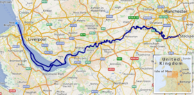
The Mersey starts at the confluence of the River Tame and River Goyt in Stockport. It flows westwards through south Manchester, then into the Manchester Ship Canal at Irlam, becoming a part of the canal and maintaining its water levels. After 4 miles (6.4 km) it exits the canal, flowing towards Warrington where it widens. It then narrows as it passes between Runcorn and Widnes. The river widens into a large estuary, which is 3 miles (4.8 km) across at its widest point near Ellesmere Port. The course of the river then turns northwards as the estuary narrows between Liverpool and Birkenhead on the Wirral Peninsula to the west, and empties into Liverpool Bay. In total the river flows 69 miles (111 km).[4]
A railway tunnel between Birkenhead and Liverpool as part of the Mersey Railway opened in 1886. Two road tunnels pass under the estuary from Liverpool: the Queensway Tunnel opened in 1934 connecting the city to Birkenhead, and the Kingsway Tunnel, opened in 1971, to Wallasey. A road bridge, completed in 1961 and later named the Silver Jubilee Bridge, crosses between Runcorn and Widnes, adjacent to the Runcorn Railway Bridge which opened in 1868. A second road bridge, the Mersey Gateway, opened in October 2017, carrying a six-lane road connecting Runcorn's Central Expressway with Speke Road and Queensway in Widnes.[5] The Mersey Ferry operates between Pier Head in Liverpool and Woodside in Birkenhead and Seacombe, and has become a tourist attraction offering cruises that provide an overview of the river and surrounding areas.
Water quality in the Mersey was severely affected by industrialisation, and in 1985, the Mersey Basin Campaign was established to improve water quality and encourage waterside regeneration. In 2009 it was announced that the river is "cleaner than at any time since the industrial revolution" and is "now considered one of the cleanest in the UK". The Mersey Valley Countryside Warden Service manages local nature reserves such as Chorlton Ees and Sale Water Park.
The river gave its name to Merseybeat, developed by bands from Liverpool, notably the Beatles. In 1965 it was the subject of the top-ten hit single "Ferry Cross the Mersey" by Gerry and the Pacemakers.
^"Mersey Estuary". Ramsar Sites Information Service. Retrieved 4 January 2022.
^Arrowsmith, Peter (1997). Stockport: a History. Stockport: Stockport Metropolitan Borough Council. p. 21. ISBN 978-0-905164-99-1.
^Mills, A D (1998). A dictionary of English place-names. Oxford: Oxford University Press. p. 240. ISBN 978-0-19-280074-9.
^Clayton, Phil (2012). Headwaters: Walking to British River Sources (First ed.). London: Frances Lincoln Limited. p. 126. ISBN 9780711233638.
^"Mersey Gateway Bridge is now open | The Mersey Gateway Project". merseygateway.co.uk. Archived from the original on 27 October 2017. Retrieved 27 October 2017.
The RiverMersey (/ˈmɜːrzi/) is a major river in North West England. Its name derives from Old English and means "boundary river", possibly referring to...
MerseyRiver may mean: the MerseyRiver (Tasmania) in Tasmania, Australia. the MerseyRiver (Nova Scotia) in Nova Scotia, Canada. the RiverMersey in Liverpool...
The Queensway Tunnel is a road tunnel under the RiverMersey, in the north west of England, between Liverpool and Birkenhead. Locally, it is often referred...
each other. The Trent and Mersey Canal (T&M) was built to link the River Trent at Derwent Mouth in Derbyshire to the RiverMersey, and thereby provide an...
The Mersey Tunnels connect the city of Liverpool with Wirral, under the RiverMersey. There are three tunnels: the Mersey Railway Tunnel, opened 1886...
Mersey, related Gerry Marsden's Merseybeat days; it premiered in Liverpool and played in the UK, Australia, and Canada. "Mersey" refers to the River Mersey...
The River Irwell (/ˈɜːrwɛl/ UR-wel) is a tributary of the RiverMersey in north-west England. It rises at Irwell Springs on Deerplay Moor, approximately...
which lies on the opposite bank of the RiverMersey to Liverpool. Both sides of the river were connected via the Mersey Railway Tunnel. The railway opened...
Kingsway Tunnel (or Wallasey Tunnel) is a toll road tunnel under the RiverMersey between Liverpool and Wallasey. The 1.5 mi (2.4 km) tunnel carries the...
Lancashire, Heaton Mersey lies on the north bank of the RiverMersey, just a few miles downstream from its source in Stockport town centre. The river acts as a...
population in 2021 was 62,100. Runcorn is on the southern bank of the RiverMersey, where the estuary narrows to form the Runcorn Gap. Runcorn was founded...
3°01′30″W / 53.416°N 3.025°W / 53.416; -3.025 The Mersey Ferry is a ferry service operating on the RiverMersey in north west England, between Liverpool to...
and administers the dock facilities of the Port of Liverpool, on the RiverMersey, England. These include the operation of the enclosed northern dock system...
The Mersey Gateway Bridge is a toll bridge between Runcorn and Widnes in Cheshire, England, which spans the RiverMersey and the Manchester Ship Canal...
Starting at the Mersey Estuary at Eastham, near Ellesmere Port, Cheshire, it generally follows the original routes of the riversMersey and Irwell through...
the northern bank of the RiverMersey where the estuary narrows to form the Runcorn Gap. Directly to the south across the Mersey is the town of Runcorn...
connected St Helens to the RiverMersey at Spike Island in Widnes. Originally it followed the valley of the Sankey Brook from the Mersey through Warrington to...
A Mersey flat is a type of doubled-ended barge, they were commonly used on the RiverMersey. Traditionally, the hull was built of oak and the deck was...
lower reaches. It empties into the RiverMersey, near to where the Mersey itself flows into the Irish Sea. The river has benefited from clean-up schemes...
District National Park. The RiverMersey runs through the north of Cheshire before broadening into its wide estuary; the River Dee forms part of the county's...
and 12 miles (19 km) north of Macclesfield. The River Goyt and Tame merge to create the RiverMersey here. It is the main settlement of the wider Metropolitan...
population of 9,693 at the 2011 census. It lies on the south bank of the RiverMersey, 5 miles (8.0 km) south of Manchester city centre. Historically part...
Didsbury is a suburb of Manchester, England, on the north bank of the RiverMersey, 5 miles (8 kilometres) south of Manchester city centre. The population...
The River Goyt is a tributary of the RiverMersey in North West England. The name Goyt may be derived from the Middle English gote, meaning "a watercourse...
the same name in Cheshire, England. The town sits on the banks of the RiverMersey and is historically part of Lancashire. It is 19 miles (31 km) east of...
 Global Information