Rivière Rouge (former French name), Río Colorado (former Spanish name)
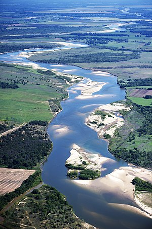
Red River looking east, north of Bonham, Texas:
Texas is to the right, Oklahoma is on the left, and the border between the two states runs along the south (right) bank of the river.
Map of the Red River watershed
Native name
Bah'hatteno(Caddo)[1]
Location
Country
United States
States
Texas, Oklahoma, Arkansas and Louisiana
Physical characteristics
Source
• location
Confluence of the Prairie Dog Town Fork and Buck Creek, Harmon County, Oklahoma[2]
The Red River, or sometimes the Red River of the South to differentiate it from the Red River in the north of the continent, is a major river in the Southern United States.[3] It was named for its reddish water color from passing through red-bed country in its watershed.[4] It is known as the Red River of the South to distinguish it from the Red River of the North, which flows between Minnesota and North Dakota into the Canadian province of Manitoba. Although once a tributary of the Mississippi River, the Red River is now a tributary of the Atchafalaya River, a distributary of the Mississippi that flows separately into the Gulf of Mexico. This confluence is connected to the Mississippi River by the Old River Control Structure.
The south bank of the Red River formed part of the US–Mexico border from the Adams–Onís Treaty (in force 1821) until the Texas Annexation and the Treaty of Guadalupe Hidalgo.
The Red River is the second-largest river basin in the southern Great Plains.[5] It rises in two branches in the Texas Panhandle and flows east, where it serves as the border between the states of Texas and Oklahoma. It forms a short border between Texas and Arkansas before entering Arkansas. It forms much of the eastern border of Miller County, Arkansas, turning south near Fulton and flowing into Louisiana, where it feeds the Atchafalaya River. The total length of the river is 1,360 miles (2,190 km), with a mean flow of over 57,000 cubic feet per second (1,600 m3/s) at the mouth.[citation needed]
^Caddo name. Meredith, Howard. "Caddo (Kadohadacho)." Archived 2010-07-19 at the Wayback Machine Oklahoma Historical Society's Encyclopedia of Oklahoma History and Culture. Retrieved 9 Sept 2012)
^Cite error: The named reference USGS was invoked but never defined (see the help page).
^Tyson, Carl N. The Red River in Southwestern History. Norman: University of Oklahoma Press, 1981. ISBN 0-8061-1659-5
^"Red River Basin". Texas Water Development Board. Retrieved 5 Dec 2020.
^Benke, Arthur; Colbert Cushing (2005). River of North America. Academic Press. p. 1144. ISBN 9780120882533.
and 22 Related for: Red River of the South information
generating facilities along the Ohio River. TheRedRiveroftheSouth is the 10th longest river in the United States with a length of 1,290 miles (2,080 km)...
TheRedRiver campaign, also known as theRedRiver expedition, was a major Union offensive campaign in the Trans-Mississippi theater ofthe American Civil...
TheRedRiver War was a military campaign launched by the United States Army in 1874 to displace the Comanche, Kiowa, Southern Cheyenne, and Arapaho tribes...
Mississippi River and RedRiver in south central Louisiana in the United States. It flows south, just west ofthe Mississippi River, and is the fifth largest...
in the valley oftheRedRiveroftheSouth through five radio stations. The network is headquartered in Shreveport, Louisiana, on the campus of Louisiana...
source of Lake Itasca in northern Minnesota, it flows generally south for 2,340 miles (3,766 km) to the Mississippi River Delta in the Gulf of Mexico...
TheRedRiver flood of 1997 was a major flood that occurred in April and May 1997 along theRedRiverofthe North in Minnesota, North Dakota, and southern...
TheRedRiver Bridge War was a boundary conflict between the U.S. states of Oklahoma and Texas over an existing toll bridge and a new free bridge crossing...
The Ouachita River (/ˈwɑːʃɪtɑː/ WAH-shi-taw) is a 605-mile-long (974 km) river that runs south and east through the U.S. states of Arkansas and Louisiana...
Eucalyptus camaldulensis, commonly known as theriverred gum, is a species of flowering plant in the family Myrtaceae, and is endemic to Australia. It...
Indies and South Americas). The longest rivers in each country are included. Further details and references are provided in each river's separate article...
Illinois River. It also appears to have pushed the course ofthe Ohio River further south and the Mississippi River further west. The bluffs carved by the torrent...
the "Rigolette de Bon Dieu." Fountain in the historic Cane River in Natchitoches, Louisiana Isle Brevelle Natchitoches Parish RedRiveroftheSouth Anne...
TheRedRiver Colony (or Selkirk Settlement), also known as Assiniboia, was a colonization project set up in 1811 by Thomas Douglas, 5th Earl of Selkirk...
TheRed Deer River is a river in Alberta and a small portion of Saskatchewan, Canada. It is a major tributary oftheSouth Saskatchewan River and is part...
 Global Information