Tectonic map of Alaska and northwestern Canada showing main faults and historic earthquakes
The Queen Charlotte Fault is an active transform fault that marks the boundary of the North American plate and the Pacific plate.[1][2] It is Canada's right-lateral strike-slip equivalent to the San Andreas Fault to the south in California.[3] The Queen Charlotte Fault forms a triple junction south with the Cascadia subduction zone and the Explorer Ridge (the Queen Charlotte Triple Junction). The Queen Charlotte Fault (QCF) forms a transpressional plate boundary, and is as active as other major transform fault systems (i.e. San Andreas, Alpine) in terms of slip rates and seismogenic potential.[4] It sustains the highest known deformation rates among continental or continent-ocean transform systems globally, accommodating greater than 50mm/yr dextral offset.[5] The entire approximately 900 km offshore length has ruptured in seven greater than magnitude 7 events during the last century, making the cumulative historical seismic moment release higher than any other modern transform plate boundary system.[6]
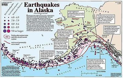
The fault is named for the Queen Charlotte Islands (now Haida Gwaii) which lie just north of the triple junction. The Queen Charlotte Fault continues northward along the Alaskan coast where it is called the Fairweather Fault.[7] The two segments are collectively called the Queen Charlotte-Fairweather Fault System.
^Trehu, A. M.; Scheidhauer, M.; Rohr, K. M. M.; Tikoff, B.; Walton, M. A. L.; Gulick, S. P. S.; Roland, E. C. (2015-03-03). "An Abrupt Transition in the Mechanical Response of the Upper Crust to Transpression along the Queen Charlotte Fault". Bulletin of the Seismological Society of America. 105 (2B): 1114–1128. Bibcode:2015BuSSA.105.1114T. doi:10.1785/0120140159. hdl:2152/43270. ISSN 0037-1106. S2CID 128679814.
^Walton, M. A. L.; Gulick, S. P. S.; Haeussler, P. J.; Roland, E. C.; Trehu, A. M. (2015-04-14). "Basement and Regional Structure Along Strike of the Queen Charlotte Fault in the Context of Modern and Historical Earthquake Ruptures". Bulletin of the Seismological Society of America. 105 (2B): 1090–1105. Bibcode:2015BuSSA.105.1090W. doi:10.1785/0120140174. hdl:2152/43271. ISSN 0037-1106. S2CID 59376353.
^Rohr, K. M. M.; Tryon, A. J. (2010). "Pacific-North America plate boundary reorganization in response to a change in relative plate motion: Offshore Canada". Geochemistry, Geophysics, Geosystems. 11 (6). Bibcode:2010GGG....11.6007R. doi:10.1029/2009GC003019. ISSN 1525-2027. S2CID 129230105.
^Yue, Han; Lay, Thorne; Freymueller, Jeffrey T.; Ding, Kaihua; Rivera, Luis; Ruppert, Natalia A.; Koper, Keith D. (November 2013). "Supershear rupture of the 5 January 2013 Craig, Alaska ( M w 7.5) earthquake: 2013 CRAIG EARTHQUAKE SUPERSHEAR RUPTURE". Journal of Geophysical Research: Solid Earth. 118 (11): 5903–5919. doi:10.1002/2013JB010594. S2CID 3754158.
^Brink, U. S. ten; Miller, N. C.; Andrews, B. D.; Brothers, D. S.; Haeussler, P. J. (2018). "Deformation of the Pacific/North America Plate Boundary at Queen Charlotte Fault: The Possible Role of Rheology". Journal of Geophysical Research: Solid Earth. 123 (5): 4223–4242. Bibcode:2018JGRB..123.4223T. doi:10.1002/2017JB014770. hdl:1912/10462. ISSN 2169-9356. S2CID 133742253.
^Bostwick, T. (1984). A re-examination of the August 22, 1949 Queen Charlotte earthquake.
^Brothers, Daniel S.; Miller, Nathaniel C.; Barrie, J. Vaughn; Haeussler, Peter J.; Greene, H. Gary; Andrews, Brian D.; Zielke, Olaf; Watt, Janet; Dartnell, Peter (2020-01-15). "Plate boundary localization, slip-rates and rupture segmentation of the Queen Charlotte Fault based on submarine tectonic geomorphology". Earth and Planetary Science Letters. 530: 115882. Bibcode:2020E&PSL.53015882B. doi:10.1016/j.epsl.2019.115882. hdl:10754/660310. ISSN 0012-821X. S2CID 210615976.
and 26 Related for: Queen Charlotte Fault information
The QueenCharlotteFault is an active transform fault that marks the boundary of the North American plate and the Pacific plate. It is Canada's right-lateral...
gwaay, literally "Islands of the Haida people"), also known as the QueenCharlotte Islands, is an archipelago located between 55–125 km (34–78 mi) off...
reported in this earthquake. The 1949 QueenCharlotte Islands earthquake was caused by a rupture on the QueenCharlotteFault, which forms part of the boundary...
then the Ulakhan Fault between it and the Okhotsk Plate, and finally the Aleutian Trench to the end of the QueenCharlotteFault system (see also: Aleutian...
The New Madrid Seismic Zone (NMSZ), sometimes called the New Madrid Fault Line, is a major seismic zone and a prolific source of intraplate earthquakes...
interrupted in Bella Coola. Although the earthquake occurred on the QueenCharlotteFault, a primarily strike-slip boundary between the Pacific and North...
with the Ulakhan Fault and the northern end of the Kuril–Kamchatka Trench, to a junction with the northern end of the QueenCharlotteFault system in the...
intersect here are the QueenCharlotteFault, the northern Cascadia subduction zone, and the Explorer Ridge. The QueenCharlotte triple junction is currently...
intersects the QueenCharlotteFault and the Explorer Ridge. To the south, just off Cape Mendocino in California, it intersects the San Andreas Fault and the...
formed as a result of the Pacific Plate sliding northward along the QueenCharlotteFault, on its way to the Aleutian Trench, which extends along the southern...
the Sovanco Fracture Zone to the QueenCharlotte Triple Junction, a point where it meets the QueenCharlotteFault and the northern Cascadia subduction...
The range is home to the Fairweather Fault, an active geologic transform fault of the larger QueenCharlotteFault along the boundary between the Pacific...
beneath western QueenCharlotte Sound but not elsewhere in the QueenCharlotte Basin. Caprock-breaching faults are sparser in QueenCharlotte Sound than in...
the North American Plate. The QueenCharlotteFault on the Pacific Northwest coast of North America The Motagua Fault, which crosses through Guatemala...
and volcanic activity in the belt has likely ceased. The active QueenCharlotteFault on the west coast of the Haida Gwaii, British Columbia, has generated...
Eltanin Fault System Macquarie Fault Zone Mendocino Fracture Zone Murray Fracture Zone Molucca Sea Collision Zone QueenCharlotteFault Sorong Fault Carnegie...
collision totally ends slightly further east, where the QueenCharlotteFault becomes the dominant fault of the tectonic regime. This specific area of the Aleutian...
aligns with the West Coast fault and QueenCharlotteFault system of strike-slip fault zones (similar to the San Andreas Fault in California) on the west...
earthquake, magnitude Mw 7.6 associated with strike-slip on the QueenCharlotteFault - the first supershear event recognised on an oceanic plate boundary...
a seismically active site southwest of the southern end of the QueenCharlotteFault. They are named after Canadian geologist John Tuzo Wilson. The two...
with the Pacific Northwest, creating a transform fault plate boundary similar to the QueenCharlotteFault. During this passive plate boundary, the Kula...
communication systems. The earthquake struck along the strike-slip QueenCharlotteFault, connecting Alaska's Aleutian Islands tectonic area with Southeast...
Cascadia subduction zone and the Pacific Plate sliding along the QueenCharlotteFault. Large earthquakes have led to collapsing mountains, landslides...
extensional forces as the Pacific Plate slides northward along the QueenCharlotteFault to the west, on its way to the Aleutian Trench, which extends along...
strike-slip faulting exists. When this transition ends, faulting is completely right-lateral transform and is largely accommodated along the QueenCharlotte Fault...
 Global Information