Global Information Lookup Global Information

Plate Boundary Observatory information


The Plate Boundary Observatory (PBO) was the geodetic component of the EarthScope Facility. EarthScope was an earth science program that explored the 4-dimensional structure of the North American Continent.[1] EarthScope (and PBO) was a 15-year project (2003-2018) funded by the National Science Foundation (NSF) in conjunction with NASA. PBO construction (an NSF MREFC) took place from October 2003 through September 2008.[2] Phase 1 of operations and maintenance concluded in September 2013. Phase 2 of operations ended in September 2018, along with the end of the EarthScope project. In October 2018, PBO was assimilated into a broader Network of the Americas (NOTA), along with networks in Mexico (TLALOCNet) and the Caribbean (COCONet), as part of the NSF's Geodetic Facility for the Advancement of Geosciences (GAGE). GAGE is operated by EarthScope Consortium.

PBO precisely measured Earth deformation resulting from the constant motion of the Pacific and North American tectonic plates in the western United States. These Earth movements can be very small and incremental and not felt by people, or they can be very large and sudden, such as those that occur during earthquakes and volcanic eruptions. The high-precision instrumentation of the PBO enabled detection of motions to a sub-centimeter level. PBO measured Earth deformation through a network of instrumentation including: high-precision Global Positioning System (GPS) and Global Navigation Satellite System (GNSS) receivers, strainmeters, seismometers, tiltmeters, and other geodetic instruments.

The PBO GPS network included 1100 stations extending from the Aleutian Islands south to Baja and eastward across the continental United States. During the construction phase, 891 permanent and continuously operating GPS stations were installed, and another 209 existing stations were integrated (PBO Nucleus stations) into the network. Geodetic imaging data was transmitted, often in realtime, from a wide network of GPS stations, augmented by seismometers, strainmeters and tiltmeters, complemented by InSAR (interferometric synthetic aperture radar), LiDAR (light-activated radar), and geochronology.

The GPS stations were categorized into clusters. The transform cluster was near the San Andreas Fault in California; the subduction cluster was in the Cascadia subduction zone (northern California, Oregon, Washington, and southern British Columbia); the extension cluster was in the Basin and Range region; the volcanic cluster was in the Yellowstone caldera, the Long Valley caldera, and the Cascade volcanoes; the backbone cluster was at 100–200 km intervals across the United States to provide complete spatial coverage.
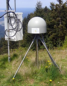
An EarthScope GPS sensor, a component of the Plate Boundary Observatory (PBO) system.

Data from the PBO was, and NOTA data continue to be, transmitted to the GAGE Facility, operated by EarthScope Consortium, to the data center where it is collected, archived and distributed. These data sets continue to be freely and openly available to the public, with equal access provided for all users. PBO data includes the raw data collected from each instrument, quality-checked data in formats commonly used by PBO's various user communities, and processed data such as calibrated time series, velocity fields, and error estimates.

Some scientific questions that addressed by the EarthScope project and the PBO data include:[3]

  • How does accumulated strain lead to earthquakes?
  • Are there recognizable precursors to earthquakes?
  • How does the evolution of the continent influence the motions that are happening today?
  • What happens to geologic structures at depth?
  • What influences the location of features such as faults and mountain ranges?
  • Is it inherited from earlier tectonic events or related to deeper processes in the mantle?
  • How is magma generated? How does it travel from the mantle to reach the surface?
  • What are the precursors to a volcanic eruption?[4]
  1. ^ "EarthScope". EarthScope.
  2. ^ UNAVCO (2009). Plate Boundary Observatory: The first five years. p. 10.
  3. ^ Williams, M.L., K.M. Fische r, J.T. Freymuelle r, B. Tikoff, A.M. T réhu; et al. (February 2010). Unlocking the Secrets of the North American Continent: An EarthScope Science Plan for 2010-2020 (PDF). p. 78. Archived from the original (PDF) on 14 April 2015. Retrieved 9 April 2015.{{cite book}}: CS1 maint: multiple names: authors list (link)
  4. ^ National Research Council, Review of EarthScope Integrated Science (Washington D.C., National Academy Press, 2001).

and 27 Related for: Plate Boundary Observatory information

Request time (Page generated in 0.806 seconds.)

Plate Boundary Observatory

Last Update:

The Plate Boundary Observatory (PBO) was the geodetic component of the EarthScope Facility. EarthScope was an earth science program that explored the 4-dimensional...

Word Count : 668

EarthScope

Last Update:

project had three components: USArray, the Plate Boundary Observatory, and the San Andreas Fault Observatory at Depth. Organizations associated with the...

Word Count : 4463

UNAVCO

Last Update:

with processing of the geodetic data. In the large EarthScope Plate Boundary Observatory, now known as the "Network of the Americas" (NOTA), UNAVCO acquired...

Word Count : 3159

Plate tectonics

Last Update:

motion determines the type of plate boundary (or fault): convergent, divergent, or transform. The relative movement of the plates typically ranges from zero...

Word Count : 13617

Yellowstone Volcano Observatory

Last Update:

public. The observatory undertook a monitoring plan in 2006 that served as the basis for upgrades undertaken by the Plate Boundary Observatory, and by the...

Word Count : 503

Strainmeter

Last Update:

a major effort (the Plate Boundary Observatory) to install many more strainmeters along the Pacific/North-America plate boundary in the United States...

Word Count : 382

PBO

Last Update:

code: PBO) Pine Bluff Observatory, an astronomical observatory in Wisconsin, USA Plate Boundary Observatory, a geodetic observatory in the western United...

Word Count : 217

Tsunami warning system

Last Update:

of UNESCO. In 2005, Chile started to implement the Integrated Plate boundary Observatory Chile (IPOC) which in the following years become a network of...

Word Count : 2545

Augustine Volcano

Last Update:

level during the months leading up to the 2005–2006 eruption. The Plate Boundary Observatory has a network of 10 high-precision GPS instruments on the flanks...

Word Count : 1142

San Andreas Fault

Last Update:

California. It forms part of the tectonic boundary between the Pacific Plate and the North American Plate. Traditionally, for scientific purposes, the...

Word Count : 3839

USArray

Last Update:

Earthscope project [the other two being the Plate Boundary Observatory (PBO) and the San Andreas Fault Observatory at Depth (SAFOD)], funded by the National...

Word Count : 470

Juan de Fuca Ridge

Last Update:

The Juan de Fuca Ridge is a mid-ocean spreading center and divergent plate boundary located off the coast of the Pacific Northwest region of North America...

Word Count : 1388

Galapagos Rise

Last Update:

divergent boundary located between the South American coast and the triple junction of the Nazca Plate, the Cocos Plate, and the Pacific Plate. The volcanically...

Word Count : 172

Volcano

Last Update:

are most often found where tectonic plates are diverging or converging, and because most of Earth's plate boundaries are underwater, most volcanoes are...

Word Count : 9880

Ring of Fire

Last Update:

Plate; the Pacific and Juan de Fuca plates beneath the North American Plate; the Philippine plate beneath the Eurasian plate; and a complex boundary between...

Word Count : 9603

Paul Silver

Last Update:

continental scale, Silver played a key role in establishing the Plate Boundary Observatory, a part of the large EarthScope research program, which observes...

Word Count : 825

National Centre for Seismology

Last Update:

of the Indian Plate and its interaction with the neighboring Eurasian Plate in the north. Most of earthquakes occur in the plate boundary regions; however...

Word Count : 605

Krafla

Last Update:

Mid-Atlantic Ridge, which forms the divergent boundary between the North American Plate and the Eurasian Plate. Its highest peak reaches up to 818 m (2,684 ft)...

Word Count : 731

Lunar Laser Ranging experiments

Last Update:

Lick Observatory. Observations from Air Force Cambridge Research Laboratories Lunar Ranging Observatory in Arizona, the Pic du Midi Observatory in France...

Word Count : 3478

Caucasus Mountains

Last Update:

tectonic plate collision between the Arabian Plate moving northwards with respect to the Eurasian Plate. As the Tethys Sea was closed and the Arabian Plate collided...

Word Count : 2346

Sulaiman Mountains

Last Update:

Ghazi Khan and Rajanpur, which are located west of the Indus River on the boundary with Balochistan. Bordering the mountains to the east are the plains of...

Word Count : 1136

Hawaii hotspot

Last Update:

created by geological activity at tectonic plate boundaries, the Hawaiʻi hotspot is located far from plate boundaries. The classic hotspot theory, first proposed...

Word Count : 7840

Carte du Ciel

Last Update:

at the zone boundaries, such that each observatory's plates would overlap with those of the adjacent zones. The participating observatories agreed to use...

Word Count : 1812

Walter Alvarez

Last Update:

Lamont–Doherty Geological Observatory of Columbia University, and began studying the Mediterranean tectonics in the light of the new theory of plate tectonics. His...

Word Count : 1250

2023 Noto earthquake

Last Update:

the boundary between the Amur Plate and the Okhotsk Plate. In this area, the Okhotsk Plate is converging to the west-northwest towards the Amur Plate with...

Word Count : 1393

Earth

Last Update:

divergent boundaries, two plates are pulled apart; and at transform boundaries, two plates slide past one another laterally. Along these plate boundaries, earthquakes...

Word Count : 19285

Seismicity of the New York City area

Last Update:

less seismically active than California because it is far from any plate boundaries. Large and damaging intraplate earthquakes are relatively rare but...

Word Count : 2215

PDF Search Engine © AllGlobal.net