6,475 km2 (2,500 sq mi)https://dgkhan.punjab.gov.pk/tribal_area
Geography
Sulaiman Range
Location
Show map of Balochistan, Pakistan
Sulaiman Range
Sulaiman Range (Pakistan)
Show map of Pakistan
Location
Zabul, Kandahar and Loya Paktia, Afghanistan Balochistan, and Khyber Pakhtunkhwa, Pakistan
Parent range
Hindu Kush
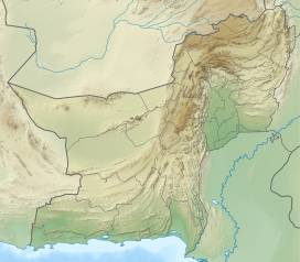
The Sulaiman Mountains, also known as Kōh-e Sulaymān (Balochi:کوهِ سليمان; "Mountains of Prophet Solomon") or Da Kasē Ghrūna (Pashto: د كسې غرونه; "Mountains of Kasi"), are a north–south extension of the southern Hindu Kush mountain system in Pakistan and Afghanistan. They rise to form the eastern edge of the Iranian plateau.[1] They are located in the Kandahar, Zabul and Paktia provinces of Afghanistan, and in Pakistan they extend over the northern part of Balochistan and Waziristan as well as Kurram of Khyber Pakhtunkhwa. In southwestern Punjab, the mountains extend into the two districts of Dera Ghazi Khan and Rajanpur, which are located west of the Indus River on the boundary with Balochistan. Bordering the mountains to the east are the plains of the Indus River valley, and to the north are the arid highlands of the Central Hindu Kush whose heights extend up to 3,383 metres (11,099 ft).[2] The total area on which this range spans around 6475 sq. km (2500 sq mi)[3].Together with the Kirthar Mountains on the border between Balochistan and Sindh, the Sulaiman Mountains form what is known as the Sulaiman-Kirthar geologic province.[4]
The most well-known peak of the Sulaimans is the twin-peaked Takht-e-Sulaiman or "Throne of Prophet Solomon" at 3,487 metres (11,440 ft),[5] located near Darazinda in Dera Ismail Khan Subdivision, close to the border with both South Waziristan and the Zhob District of neighboring Balochistan province. The highest peak, however, is Zarghun Ghar at 3,578 metres (11,739 ft) near Quetta, Pakistan. The next highest peak in Balochistan province is Khilafat Hill at 3,475 metres (11,401 ft), which is located in the Ziarat District of Pakistan and is famous for the Ziarat Juniper Forest, where Juniperus macropoda trees grow.[6]
^Akroyd, Clarissa (2014-11-17). Pakistan. Simon and Schuster. ISBN 978-1-63355-947-9.
^Khan, Fazle Karim (1991). A Geography of Pakistan: Environment, People and Economy. Oxford University Press. ISBN 978-0-19-577411-5.
^"Koh-e-Suleman | District Dera Ghazi Khan". dgkhan.punjab.gov.pk. Retrieved 2023-06-06.
^"USGS Bulletin 2208-C: Sembar Goru/Ghazij Composite Total Petroleum System, Indus and Sulaiman-Kirthar Geologic Provinces, Pakistan and India". pubs.usgs.gov. Retrieved 2020-04-20.
^Park, Graham (2017-11-09). Mountains: The origins of the Earth's mountain systems. Dunedin Academic Press Ltd. ISBN 978-1-78046-579-1.
^Shah, Syed Ali (10 July 2013). "In Balochistan, an ancient forest battles for survival". Dawn. Retrieved 28 December 2014.
and 25 Related for: Sulaiman Mountains information
The SulaimanMountains, also known as Kōh-e Sulaymān (Balochi:کوهِ سليمان; "Mountains of Prophet Solomon") or Da Kasē Ghrūna (Pashto: د كسې غرونه; "Mountains...
The mountain range forms part of the Kirthar-Sulaiman geological province, which stretches from the Arabian Sea coast north to the SulaimanMountains in...
highest peak is Mount Sikaram (4,755 m (15,600)) . SulaimanMountains; highest peak is Takht-e-Sulaiman (3,487 metres (11,440 ft)). Margalla Hills in Punjab...
rendered as Sulaiman Pi Sulaiman, professional software designer SulaimanMountains Sulaymaniyah, a city in Iraqi Kurdistan Salim–Sulaiman, Hindi music...
Sulaiman Range alpine meadows ecoregion (WWF ID: PA1018) covers a series of higher altitude mountain ranges along the crest of the SulaimanMountains...
that are not usually classed as independent mountains, but instead are considered sub-peaks of other mountains, due to having low topographic prominence...
Khan city. The district lies to the west of the Indus River. The SulaimanMountains rise to a height of 10,000 feet (3,000 m) in the north of the district...
strip of land sandwiched between the Indus River on the east and the SulaimanMountains on the west. Most of its inhabitants are Saraikis and Baloch with...
Balochistan meet. Derajat is bounded by the Indus River to the east and the SulaimanMountains to the west. The Saraiki people follow many religions, though most...
SulaimanMountains, Kirthar Mountains, Brahui range, and Pab range among others, with the Western Fold Belt along the border (between the Sulaiman Range...
This is a list of mountain ranges in Asia. "Mountains in Oman". omantourism.gov.om. Ministry of Tourism, Sultanate of Oman. Retrieved 10 November 2017...
(Pashto: توبه کاکړۍ; Urdu: توبہ کاکڑ) are a southern offshoot of the SulaimanMountains in the Balochistan province of Pakistan, extending into the Kandahar...
was built in the 13th century in a small village named Muqam in the SulaimanMountains, 35 kilometres (22 mi) from Dera Ghazi Khan city and 110 Kilometers...
therefore, with his family, and a number of Arab retainers, into the SulaimanMountains, situated between Multan and Peshawar, where he took up his residence...
and Afghanistan. The most well-known peak of the Sulaimanmountains is the twin-peaked Takht-e-Sulaiman or "Throne of Prophet Solomon" at 3,487 metres (11...
by a spur of clay and sandstone hills that stretch east from the Sulaimanmountains to the Indus river known as the Sheikh Badin Hills.[citation needed]...
Pashtun habitat during their conquest by Mahmud was located in the SulaimanMountains in the south of Afghanistan. Prior to Pashtun migration to the Kabul...
leghari' is the head quarter of the Leghari tribe. Fort Munro is part of Sulaimanmountain range. It was developed by British in the late 19th-century as a summer...
and Balochistan meet. Derajat is bound by the Indus River and the SulaimanMountains to the west. Muhajirs (meaning "migrants"), are a collective multiethnic...
scientific name proposed by Edward Blyth in 1841 for wild sheep in the SulaimanMountains. The specific name honours Godfrey Vigne (1801–1863). The vignei subspecies...
lies 40 miles (64 km) west of Dera Ismail khan in the foothills of SulaimanMountains. Daraban region has a rich, fascinating history. Over the last two...
period and its capital city located between the Hindukush and SulaimanMountains (mountains of Solomon), although Kandahar in modern times and the ancient...
to a height of 1,000 m. In Balochistan, they are confined to the SulaimanMountains and other hilly areas. Dominant tree species are phulai (Acacia modesta)...
Balochistan meet. Derajat is bound by the Indus River to the east, and the SulaimanMountains to the west. The two major cities in the region are Dera Ghazi Khan...
 Global Information