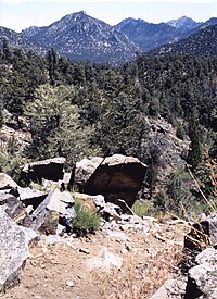
The Owens Peak Wilderness is a 73,767-acre (298.52 km2) [1] wilderness area comprising the rugged eastern face of the Sierra Nevada. Owens Peak (8,445 ft)[2] is the high point. The land was set aside with the passage of the California Desert Protection Act of 1994 (Public Law 103–433) by the US Congress.
The mountainous terrain has deep, winding, open and expansive canyons, many of which contain springs with extensive riparian vegetation. This area is a transition zone between the Great Basin, Mojave Desert and Sierra Nevada ecoregions. Vegetation varies considerably with a creosote desert scrub community on the bajadas, scattered yuccas, cacti, annuals, cottonwood and oak trees in the canyons and valleys and a juniper-pinyon woodland with sagebrush and digger/gray pine on the upper elevations.
Wildlife includes mule deer, golden eagle and prairie falcon. Evidence of occupation by prehistoric peoples has been found throughout the wilderness.
The Pacific Crest Trail passes through the wilderness along the crest and western side.
^Bureau of Land Management page on Owens Peak Wilderness.
^United States Geological Survey data page.
and 25 Related for: Owens Peak Wilderness information
old wagon road into the Owens Valley once used by soldiers and cattlemen, cross the Chimney PeakWilderness, . Chimney Peak Backcountry Byway The BLM...
Secretary of State during Frémont's brief tenure as governor (1847). OwensPeakWilderness "Owens=8451 B". NGS Data Sheet. National Geodetic Survey, National Oceanic...
The Owens River Headwaters Wilderness is a wilderness area inside the Inyo National Forest in eastern California designated to protect the headwaters...
Agua Dulce Tehachapi Pass Walker Pass OwensPeakWilderness (34) South Sierra Wilderness (34) Golden Trout Wilderness (34) Kings Canyon National Park (33)...
Manly PeakWilderness is a Bureau of Land Management wilderness area in Inyo County, California. The area was established in 1994 through the California...
second-highest peak in the wilderness, at 14,375 feet (4,382 m): it rises in one continuous sweep of granite from the floor of the Owens Valley to a peak just east...
Saddle Peak Hills Wilderness is the smallest designated wilderness area created by the California Desert Protection Act of 1994. A 1980 Bureau of Land...
southwest of Owens Lake and Olancha. Created with the passage of the California Wilderness Act of 1984 by the U.S. Congress, the South Sierra Wilderness is 62...
in two, one on each side of the Long Valley Caldera and Owens Valley. The John Muir Wilderness is a part of the Inyo National Forest and abuts Sequoia...
Mokelumne Peak is a peak in the Mokelumne Wilderness, Sierra Nevada, Amador County, California, consisting of metamorphic and granitic rock. Mokelumne Peak has...
The Owens River is a river in eastern California in the United States, approximately 183 miles (295 km) long. It drains into and through the Owens Valley...
Mountains Wilderness Area which is administered by the Bureau of Land Management. It is located east of the Owens Valley and U.S. Route 395. "Keynot Peak, California"...
Basin wildlands, east of the Owens Valley and west of the Eureka Valley. There are three separate units of the wilderness, separated by vehicle corridors...
The Silver PeakWilderness is located in the southwestern corner of Monterey County in the Santa Lucia Mountains along the Central Coast of California...
to the Owens and Fish Lake valleys, crossing Westgard Pass to the west and Gilbert Pass to the north. To the northwest lies White Mountain Peak. To the...
14,500-acre (5,900 ha) Silver PeakWilderness and added about 38,800 acres (15,700 hectares) to the Ventana Wilderness in addition to designating the...
Sespe, and Silver PeakWilderness areas. It is named for the mountain it protects, the east-west ridge of Garcia Mountain, a 3,146 ft. peak of the Santa Lucia...
Kaiser Peak, and is composed of glacier-scoured granite blocks, cirques, lakes, granitic cliffs and alpine peaks. Although a small wilderness, it is part...
The Sacatar Trail Wilderness is a federally designated wilderness area located 20 miles (32 km) northwest of Ridgecrest, California USA. It was created...
Lakes John Krebs John Muir Kaiser Kiavah Mokelumne Monarch Mount Rose OwensPeakOwens River Headwaters Sacatar Trail Sequoia-Kings Canyon South Sierra Yosemite...
700 m). Cucamonga Peak Ontario Peak Telegraph Peak (California) San Gabriel Mountains National Monument−related topics "Cucamonga Wilderness". Geographic Names...
the Ansel Adams wilderness is the Ritter Range, which includes dark metavolcanic glaciated mountains such as Mount Ritter, Banner Peak, and The Minarets...
 Global Information