US 6 / US 20 / US 422 / SR 14 / SR 43 / SR 87 at Public Square in Cleveland
Location
Country
United States
State
Ohio
Counties
Summit, Cuyahoga
Highway system
Ohio State Highway System
Interstate
US
State
Scenic
← SR 7
→ SR 9
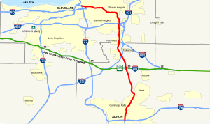
State Route 8 (SR 8) is a road in the U.S. state of Ohio. SR 8 stretches from the eastern junction of Interstate 76 (I-76) and I-77 in Akron to Public Square in Cleveland. It is one of nine routes to enter downtown Cleveland at Public Square. The route's first few miles are as a limited-access freeway from I-76 and I-77, heading north. The freeway section of the highway has 16 interchanges, and is cosigned with SR 59 for a short distance from Perkins Street in Akron to Front Street in Cuyahoga Falls. The freeway portion ends at I-271 in Macedonia.
^Cite error: The named reference GIS was invoked but never defined (see the help page).
and 27 Related for: Ohio State Route 8 information
StateRoute8 (SR 8) is a road in the U.S. state of Ohio. SR 8 stretches from the eastern junction of Interstate 76 (I-76) and I-77 in Akron to Public...
crossing most of northern Ohio. Its western terminus is at the Indiana state line near Hicksville where the route becomes Indiana State Road 37 which continues...
state of Ohio. At about 336 miles (541 km) in length, it is the longest stateroute in Ohio. Its southern terminus is an interchange with U.S. Route 52...
longest stateroute in Ohio. Its southern terminus is at U.S. Route 42 in Cincinnati, Ohio, and its northern terminus is at U.S. Route 6 in Sandusky, Ohio. Its...
StateRoute 18 (SR 18) is an east–west highway in northern Ohio. It is the sixth longest stateroute in the state. Its western terminus is at the Indiana...
StateRoutes in Ohio are owned by the state, and maintained by the state except in cities. They are signed with a white silhouette of Ohio against a black...
of the U.S. state of Ohio. It is the eighth longest stateroute in Ohio, spanning southern Ohio from Cincinnati to Belpre, across the Ohio River from Parkersburg...
StateRoute 59 (SR 59) is an east–west state highway in the U.S. state of Ohio, serving the Akron metropolitan area. The western terminus of State Route...
StateRoute 309 (SR 309) is an east–west highway in central Ohio. Its western terminus is at its interchange with U.S. Route 30 (US 30) near Delphos, and...
StateRoute 5 (SR 5) is an east–west state highway in the northeastern portion of the U.S. state of Ohio. Its western terminus is at Interstate 76 at its...
Interstate 380 (Ohio), a proposed connection between Interstate 76/Interstate 77 and Interstate 80 that is currently a part of OhioStateRoute8 U.S. roads...
StateRoute 25 (SR 25) is an Ohiostateroute that runs between Cygnet and Toledo in the US state of Ohio. The highway has a total length of 34.98 miles...
StateRoute 28 (SR 28) is an east–west state highway in the U.S. state of Ohio. Both of the route's termini are on U.S. Route 50 (US 50). Its western...
StateRoute 14, located in northeastern Ohio, runs from U.S. Route 6/U.S. Route 42/StateRoute 3 in Downtown Cleveland southeasterly to the Pennsylvania...
StateRoute 43 (SR 43) is a mainly north–south state highway that runs through the northeastern quadrant of the U.S. state of Ohio. Its southern terminus...
(377 km), it is the third longest stateroute in Ohio. The route from Ironton to West Lafayette was once signed as StateRoute 75. In 1962, to eliminate confusion...
StateRoute 49 (SR 49) is a state highway in the western part of the U.S. state of Ohio. It begins in Drexel, an area within the city of Trotwood, at...
StateRoute 73 (SR 73) is an east–west state highway in the southern portion of the U.S. state of Ohio. Its western terminus is on U.S. Route 27 in Oxford...
StateRoute 45 (SR 45) is a north–south state highway in the northeastern portion of the U.S. state of Ohio. Its southern terminus is at the State Route...
StateRoute 82 (SR 82) is a stateroute in northeastern Ohio, with a western terminus at StateRoute 57 in Lorain County, southeast of Elyria. The route...
StateRoute 10 (SR 10) is a state highway located in and around Cleveland, Ohio. The route's western terminus is in Eaton Township in Lorain County, and...
StateRoute 161 (SR 161) is an east–west state highway in central Ohio. Its western terminus is in Mutual at StateRoute 29 and its eastern terminus is...
StateRoute 235 (SR 235) is a 133.2-mile-long (214.4 km) north–south state highway in the western portion of the U.S. state of Ohio. Its southern terminus...
StateRoute 11 (SR 11) is a north–south freeway in the northeastern portion of the U.S. state of Ohio. Its southern terminus is at U.S. Route 30 (US 30)...
 Global Information