"OH 2" redirects here. The term may also refer to Ohio's 2nd congressional district.
State Route 2
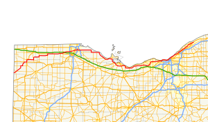
Route of SR 2 highlighted in red
Route information
Maintained by ODOT
Length
227.13 mi[1] (365.53 km)
Existed
1912[2]–present
Tourist routes
Lake Erie Circle Tour
Major junctions
West end
SR 37 near Hicksville
Major intersections
I-80 / I-90 / Ohio Turnpike near Swanton
I-475 / US 23 near Toledo
I-280 / LECT near Toledo
SR 2C in Port Clinton
I-90 in Elyria
I-90 / SR 254 in Rocky River
I-90 in Cleveland
I-90 in Euclid
SR 44 in Painesville Township
East end
US 20 in Painesville Township
Location
Country
United States
State
Ohio
Counties
Defiance, Williams, Fulton, Lucas, Ottawa, Erie, Lorain, Cuyahoga, Lake
Highway system
Ohio State Highway System
Interstate
US
State
Scenic
← SR 1
→ SR 3
← US 23
SR 23
→ US 24
State Route 2 (SR 2), formerly known as Inter-county Highway 2 until 1921[3] and State Highway 2 in 1922,[4] is an east–west highway crossing most of northern Ohio. Its western terminus is at the Indiana state line near Hicksville where the route becomes Indiana State Road 37 which continues to Fort Wayne, Indiana. The eastern terminus of the route is in Painesville Township in Lake County at U.S. Route 20 (US 20).
^Cite error: The named reference GIS was invoked but never defined (see the help page).
^Ohio State Highway Department (1912). Map of Ohio Showing Inter-County Highways(PDF) (Map). c. 1:563,200. Columbus: Ohio State Highway Department. OCLC 13716556.
^Ohio Department of Highways and Public Works (September 1921). Highway Map of Ohio Showing Conditions for Travel(PDF) (Map). c. 1:563,200. Columbus: Ohio Department of Highways and Public Works.
^Ohio Department of Highways and Public Works (April 1922). Map of Ohio State Highways Showing All Improved Roadways and Indicating System Constructed Under Administration of Gov. Harry L. Davis(PDF) (Map). c. 1:563,200. Columbus: Ohio Department of Highways and Public Works.
and 25 Related for: Ohio State Route 2 information
crossing most of northern Ohio. Its western terminus is at the Indiana state line near Hicksville where the route becomes Indiana State Road 37 which continues...
StateRoute 821 (SR 821) is a north–south state highway in the southeastern portion of the U.S. state of Ohio. A state-maintained section of the old US...
StateRoute 3 (SR 3) is a major north–south (physically northeast-southwest) highway in Ohio which leads from Cincinnati to Cleveland by way of Columbus...
longest stateroute in Ohio. Its southern terminus is at U.S. Route 42 in Cincinnati, Ohio, and its northern terminus is at U.S. Route 6 in Sandusky, Ohio. Its...
of the U.S. state of Ohio. It is the eighth longest stateroute in Ohio, spanning southern Ohio from Cincinnati to Belpre, across the Ohio River from Parkersburg...
StateRoute 12 (SR 12) is a generally northeast-southwest route in Ohio. Its western terminus is at SR 115 and SR 189 in Vaughnsville, and its eastern...
StateRoute 21 (SR 21) is a north–south state highway in northeastern Ohio. The southern terminus is north of Strasburg on U.S. Route 250. The northern...
StateRoute 18 (SR 18) is an east–west highway in northern Ohio. It is the sixth longest stateroute in the state. Its western terminus is at the Indiana...
StateRoute 8 (SR 8) is a road in the U.S. state of Ohio. SR 8 stretches from the eastern junction of Interstate 76 (I-76) and I-77 in Akron to Public...
StateRoute 25 (SR 25) is an Ohiostateroute that runs between Cygnet and Toledo in the US state of Ohio. The highway has a total length of 34.98 miles...
state of Ohio. At about 336 miles (541 km) in length, it is the longest stateroute in Ohio. Its southern terminus is an interchange with U.S. Route 52...
StateRoutes in Ohio are owned by the state, and maintained by the state except in cities. They are signed with a white silhouette of Ohio against a black...
StateRoute 124 (SR 124) is an east–west state highway in the southern portion of the U.S. state of Ohio. Its western terminus is at StateRoute 134 nearly...
StateRoute 73 (SR 73) is an east–west state highway in the southern portion of the U.S. state of Ohio. Its western terminus is on U.S. Route 27 in Oxford...
StateRoute 41 (SR 41) is a north–south state highway in the southern and western portions of the U.S. state of Ohio. Its southern terminus is at U.S....
StateRoute 125 (SR 125) is an east–west state highway in the southwestern portion of the U.S. state of Ohio. Its western terminus is within the Cincinnati...
StateRoute 67 (SR 67) is a northeast–southwest state highway in the U.S. state of Ohio. Its western terminus is at an interchange with U.S. Route 33 (US...
StateRoute 60 (SR 60) is a north–south state highway that runs the entire length of the U.S. state of Ohio, from the Williamstown Bridge over the Ohio...
StateRoute 49 (SR 49) is a state highway in the western part of the U.S. state of Ohio. It begins in Drexel, an area within the city of Trotwood, at...
StateRoute 19 (SR 19) is a north–south route in northern and central Ohio. Its southern terminus is at U.S. Route 42 in the unincorporated village of...
StateRoute 555 (SR 555) is a 62.36-mile-long (100.36 km), north–south running state highway that passes through four counties in southeastern Ohio. State...
StateRoute 59 (SR 59) is an east–west state highway in the U.S. state of Ohio, serving the Akron metropolitan area. The western terminus of State Route...
StateRoute 53 is a north–south state highway in the U.S. state of Ohio (physically northeast-southwest). Its southern terminus is at the beginning of...
StateRoute 11 (SR 11) is a north–south freeway in the northeastern portion of the U.S. state of Ohio. Its southern terminus is at U.S. Route 30 (US 30)...
 Global Information