US 22 in Wintersville SR 39 / SR 9 / SR 332 in Carrollton US 30 in Canton US 62 near Canton I-76 near Kent SR 14 / SR 303 To I-480 / I-80 / Ohio Turnpike in Streetsboro I-77 / I-490 in Cleveland I-90 in Cleveland
West end
US 6 / US 20 / US 42 / US 422 / SR 8 / SR 14 / SR 87 at Public Square in Cleveland
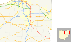
State Route 43 (SR 43) is a mainly north–south state highway that runs through the northeastern quadrant of the U.S. state of Ohio. Its southern terminus is at a signalized intersection with State Route 7 along the Ohio River in Steubenville, and its western terminus is approximately 123 miles (198 km) to the north at Public Square in Cleveland. It is one of ten routes to enter Public Square.
Created in the mid-1920s, State Route 43 starts out in Steubenville, and runs northwesterly to Canton via Carrollton. From Canton, the highway runs northerly through Kent and Streetsboro to Aurora, where it then turns northwesterly through Solon, Ohio, and continues passing through suburban Cleveland before entering the city proper, and coming to an end in downtown at Public Square. For its northernmost stretch of less than 1 mile (1.6 km), State Route 43 shares the same portion of pavement as four other highways at the same time: U.S. Route 422, State Route 8, State Route 14 and State Route 87. The five routes share a common endpoint in the middle of Public Square, where they intersect the triplex of U.S. Route 6, U.S. Route 42 and State Route 3.
^Cite error: The named reference DESTAPE was invoked but never defined (see the help page).
and 30 Related for: Ohio State Route 43 information
StateRoute43 (SR 43) is a mainly north–south state highway that runs through the northeastern quadrant of the U.S. state of Ohio. Its southern terminus...
StateRoute 3 (SR 3) is a major north–south (physically northeast-southwest) highway in Ohio which leads from Cincinnati to Cleveland by way of Columbus...
crossing most of northern Ohio. Its western terminus is at the Indiana state line near Hicksville where the route becomes Indiana State Road 37 which continues...
StateRoute 10 (SR 10) is a state highway located in and around Cleveland, Ohio. The route's western terminus is in Eaton Township in Lorain County, and...
StateRoute 8 (SR 8) is a road in the U.S. state of Ohio. SR 8 stretches from the eastern junction of Interstate 76 (I-76) and I-77 in Akron to Public...
of the U.S. state of Ohio. It is the eighth longest stateroute in Ohio, spanning southern Ohio from Cincinnati to Belpre, across the Ohio River from Parkersburg...
StateRoutes in Ohio are owned by the state, and maintained by the state except in cities. They are signed with a white silhouette of Ohio against a black...
StateRoute 44 (SR 44) is a north–south state highway in the northeastern portion of the U.S. state of Ohio. It runs from a southern terminus at State...
StateRoute 28 (SR 28) is an east–west state highway in the U.S. state of Ohio. Both of the route's termini are on U.S. Route 50 (US 50). Its western...
longest stateroute in Ohio. Its southern terminus is at U.S. Route 42 in Cincinnati, Ohio, and its northern terminus is at U.S. Route 6 in Sandusky, Ohio. Its...
SR 175 begins at the intersection of Richmond Road and Aurora Road (OhioStateRoute43). It quickly intersects Cannon Road, turns right to follow Cannon...
state of Ohio. At about 336 miles (541 km) in length, it is the longest stateroute in Ohio. Its southern terminus is an interchange with U.S. Route 52...
StateRoute 18 (SR 18) is an east–west highway in northern Ohio. It is the sixth longest stateroute in the state. Its western terminus is at the Indiana...
StateRoute 59 (SR 59) is an east–west state highway in the U.S. state of Ohio, serving the Akron metropolitan area. The western terminus of State Route...
StateRoute 126 (SR 126) is a stateroute starting at the Ohio-Indiana border, at a split with StateRoute 129 near Scipio, Ohio, and ending east of Cincinnati...
StateRoute 303 (SR 303) is a 75.71-mile-long (121.84 km) OhioStateRoute that runs between Wakeman and Windham in the US state of Ohio. The highway is...
StateRoute 778 (SR 778, OH 778) is a short north–south state highway in northern Ohio. The southern terminus of SR 778 is at SR 101 approximately 9 miles...
StateRoute 82 (SR 82) is a stateroute in northeastern Ohio, with a western terminus at StateRoute 57 in Lorain County, southeast of Elyria. The route...
StateRoute 261 (SR 261) is an east–west state highway located in northeastern Ohio that passes through Medina, Summit, and Portage counties. At a length...
StateRoute 124 (SR 124) is an east–west state highway in the southern portion of the U.S. state of Ohio. Its western terminus is at StateRoute 134 nearly...
StateRoute 309 (SR 309) is an east–west highway in central Ohio. Its western terminus is at its interchange with U.S. Route 30 (US 30) near Delphos, and...
StateRoute 87 (SR 87) is an east–west highway in northeastern Ohio, a U.S. state. Its western terminus is at Public Square in downtown Cleveland. It...
StateRoute 14, located in northeastern Ohio, runs from U.S. Route 6/U.S. Route 42/StateRoute 3 in Downtown Cleveland southeasterly to the Pennsylvania...
(377 km), it is the third longest stateroute in Ohio. The route from Ironton to West Lafayette was once signed as StateRoute 75. In 1962, to eliminate confusion...
StateRoute 555 (SR 555) is a 62.36-mile-long (100.36 km), north–south running state highway that passes through four counties in southeastern Ohio. State...
eastern end becoming StateRoute 416. KML file (edit • help) Template:Attached KML/OhioStateRoute 16 KML is from Wikidata "DESTAPE". Ohio Department of Transportation...
 Global Information