May 1981 (Waimangu) June 1951 (Rotomahana) June to August 1886 (Tarawera)
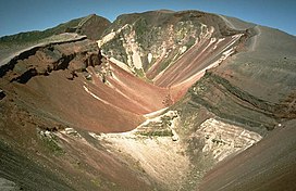
Mount Tarawera is a volcano on the North Island of New Zealand within the older but volcanically productive Ōkataina Caldera. Located 24 kilometres southeast of Rotorua, it consists of a series of rhyolitic lava domes that were fissured down the middle by an explosive basaltic eruption in 1886. While the 1886 eruption was basaltic, study has shown there was only a small basalt component to the previous recent rhyolitic predominant eruptions.[2] This eruption was one of New Zealand's largest historical eruptions, and killed an estimated 120 people. The fissures run for about 17 kilometres (11 mi) northeast–southwest.
The volcano's component domes include Ruawahia Dome (the highest at 1,111 metres), Tarawera Dome and Wahanga Dome. It is surrounded by several lakes, most of which were created or drastically altered by the 1886 eruption. These include Lakes Tarawera, Rotomahana, Rerewhakaaitu, Ōkataina, Ōkareka, Tikitapu / Blue and Rotokākahi / Green. The Tarawera River runs northeastwards across the northern flank of the mountain from Lake Tarawera.
In 2000, the mountain was ceded to the Ngāti Rangitihi sub-tribe of Te Arawa. In 2002, the group and their lessee stopped previously free public access to the mountain. This decision caused angst among Rotorua residents.[3]
^"NZ Topo Map LINZ 1:50,000".
^Shane, Phil; Martin, S.B.; Smith, Victoria C.; Beggs, K.R. (2007). "Multiple rhyolite magmas and basalt injection in the 17.7 ka Rerewhakaaitu eruption episode from Tarawera volcanic complex, New Zealand". Journal of Volcanology and Geothermal Research. 164 (1–2): 1–26. doi:10.1016/j.jvolgeores.2007.04.003.
^Rowan, Juliet (2006-05-29). "120 years on, rumblings grow over Mt Tarawera access". New Zealand Herald. Retrieved 2019-12-30.
MountTarawera is a volcano on the North Island of New Zealand within the older but volcanically productive Ōkataina Caldera. Located 24 kilometres southeast...
1886 eruption of MountTarawera was a violent volcanic eruption that occurred in the early hours of 10 June 1886 at MountTarawera, near Rotorua on New...
Lake Tarawera is the largest of a series of lakes which surround the volcano MountTarawera in the North Island of New Zealand. Like the mountain, it lies...
south of the active volcano MountTarawera, and the geography was substantially altered by the 1886 eruption of MountTarawera. At a mean autumn height of...
Sunda Strait, Indonesia. The 1886 eruption of MountTarawera in New Zealand. The 1980 eruption of Mount St. Helens in Washington in the western United...
volcano MountTarawera, and past the town of Kawerau before turning north, reaching the Bay of Plenty 6 kilometres (4 mi) west of Edgecumbe. The Tarawera Falls...
recently, they were lost and thought destroyed in the 1886 eruption of MountTarawera, while new hydrothermal features formed to the south-west i.e. Waimangu...
which form tuff rings or maars, an example being the 1886 eruption of MountTarawera. Littoral cones are another hydrovolcanic feature, generated by the...
of the dormant volcano MountTarawera, and its geography was substantially altered by a major 1886 eruption of MountTarawera. Along with the mountain...
Huaynaputina". volcanocafe.org. Retrieved 9 February 2018. "A Look Inside Mount Merapi". Live Science. 8 November 2010. "Taal Volcano". Volcano Live. John...
near MountTaraweraTarawera (New Zealand electorate), parliamentary electorate from 1978 to 1996 Tarawera River, flows from Lake TaraweraTarawera Falls...
plateau. Prominent volcanic cones in the region include Mount Maunganui, MountTarawera and Mount Edgecumbe/Putauaki. These features also have cultural...
have occurred during this time: the most recent was the 1815 eruption of Mount Tambora. This is not a complete list. Year Without a Summer Volcanic winter...
White Terraces, until they were destroyed by the volcanic eruption of MountTarawera in 1886. Rotorua was elevated to borough status in 1922 and to city...
of the 1886 MountTarawera eruption, which opened several craters along a 17-kilometre (11 mi) rift stretching southwest from MountTarawera to the nearby...
Island and towards the north west of the plateau is the lava dome of MountTarawera which was split in half by a later relatively small explosive eruption...
them being encrusted in 40 meters of rock during the 1886 eruption of MountTarawera. Plitvice Lakes National Park in Croatia, with a stunning series of...
1826, followed in 1886 by the country's largest historical eruption at MountTarawera. Much of the region north of New Zealand's North Island is made up of...
hydrothermal system created on 10 June 1886 by the volcanic eruption of MountTarawera, on the North Island of New Zealand. It encompasses Lake Rotomahana...
New Zealand seen eleven days before the deadly eruption of the nearby MountTarawera, which devastated the lake and the surrounding area. 1895 – A spectral...
final Fast Forward required one team to perform a "scree run" down MountTarawera: a run down the loose rock walls directly into the mouth of the dormant...
the orders of Kabaka Mwanga II of Buganda in Namugongo. June 10 – The MountTarawera volcano erupts in New Zealand, resulting in the deaths of over 150 people...
Tarawera Falls is a 65 m (213 ft) high waterfall on the Tarawera River in the Bay of Plenty region in New Zealand's North Island. The Tarawera River flows...
Age. Some historians suspect that the change in climate was due to MountTarawera in New Zealand erupting in 1314. The Great Famine was, however, only...
marshes, draining into Lake Tarawera by Awapurohe Creek and Rotomahana's outflow of Kaiwaka Stream. The eruption of MountTarawera initially destroyed Lake...
 Global Information