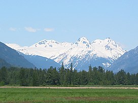
The Mount Meager massif is a group of volcanic peaks in the Pacific Ranges of the Coast Mountains in southwestern British Columbia, Canada. Part of the Cascade Volcanic Arc of western North America, it is located 150 km (93 mi) north of Vancouver at the northern end of the Pemberton Valley and reaches a maximum elevation of 2,680 m (8,790 ft). The massif is capped by several eroded volcanic edifices, including lava domes, volcanic plugs and overlapping piles of lava flows; these form at least six major summits including Mount Meager which is the second highest of the massif.
The Garibaldi Volcanic Belt (GVB) has a long history of eruptions and poses a threat to the surrounding region. Any volcanic hazard ranging from landslides to eruptions could pose a significant risk to humans and wildlife. Although the massif has not erupted for more than 2,000 years, it could produce a major eruption; if this were to happen, relief efforts would be quickly organized. Teams such as the Interagency Volcanic Event Notification Plan (IVENP) are prepared to notify people threatened by volcanic eruptions in Canada.
The Mount Meager massif produced the largest volcanic eruption in Canada in the last 10,000 years. About 2,400 years ago, an explosive eruption formed a volcanic crater on its northeastern flank and sent avalanches of hot ash, rock fragments and volcanic gases down the northern flank of the volcano. Evidence for more recent volcanic activity has been documented at the volcano, such as hot springs and earthquakes. The Mount Meager massif has also been the source of several large landslides in the past, including a massive debris flow in 2010 that swept down Meager Creek and the Lillooet River.
^ abcdefgh"Meager". Global Volcanism Program. Smithsonian Institution. Retrieved 2011-07-14.
^ abcHildreth, Wes (2007). Quaternary Magmatism in the Cascades—Geologic Perspectives. United States Geological Survey. pp. 7, 11. ISBN 978-1-4113-1945-5.
^ ab"Mount Meager". BC Geographical Names. Retrieved 2011-07-06.
and 27 Related for: Mount Meager massif information
The MountMeagermassif is a group of volcanic peaks in the Pacific Ranges of the Coast Mountains in southwestern British Columbia, Canada. Part of the...
MountMeager may refer to: MountMeagermassif, a group of mountains in British Columbia, Canada MountMeager (British Columbia), a mountain of the above...
history and one of over 20 landslides to have occurred from the MountMeagermassif in the last 10,000 years. Although voluminous, there were no fatalities...
major eruption of Mount St. Helens in 1980. It is also the site of Canada's most recent major eruption, in 410BCE at the MountMeagermassif. The Cascade Arc...
51 km (32 mi) west of Bralorne on the northeastern flank of the MountMeagermassif. With an elevation of 1,524 m (5,000 ft), it lies on the steep northern...
(British Columbia) in British Columbia, Canada MountMeagermassif in British Columbia, Canada Meager Creek, a creek in British Columbia, Canada Meagre...
eruptions as Mount Mazama (Crater Lake) about 7,500 years ago, the MountMeagermassif (Bridge River Vent) about 2,350 years ago, and Mount St. Helens in...
Snowdon Massif Ben Klibreck Cairngorms massifs Laurentian Massif Le Massif de Charlevoix Mount Logan Mount Cayley Level Mountain Mount Edziza MountMeager massif...
Belt includes the Bridge River Cones, Mount Cayley, Mount Fee, Mount Garibaldi, Mount Price, MountMeagermassif, the Squamish Volcanic Field, and more...
Silverthrone area is very similar to the Mount Meagermassif further south. However, there is much more ice. Mount Silverthrone is perhaps one of the most heavily...
volcanoes in the Cascade Volcanic Arc, such as Mount St. Helens, Glacier Peak, or the MountMeagermassif, nor has it erupted frequently. During this period...
potentially active volcanoes, notably the MountMeagermassif, Mount Garibaldi, Mount Cayley, and the Mount Edziza volcanic complex. Average winter and...
times during the past 7,300 years. Hot springs near the Mount Cayley and MountMeagermassifs suggest that magmatic heat is still present. The long history...
surface hot springs, known as the Meager Creek Hot Springs. These are related to volcanism of the MountMeagermassif on its north side. Keyhole Hot Springs...
volcanic complex, the MountMeagermassif, and a group of basaltic and andesitic volcanoes known as the Bridge River Cones. MountMeager is composed of at...
including: Mount Garibaldi, Hoodoo Mountain, Castle Rock, Mount Cayley, The Volcano, Crow Lagoon, Silverthrone Caldera, MountMeagermassif, the Wells...
peaks of the MountMeagermassif in southwestern British Columbia, Canada. Its slopes appear to be more gentle than those of the massif's other volcanic...
Assemblage is a geological formation comprising a portion of the MountMeagermassif in southwestern British Columbia, Canada. It is named after Devastator...
the MountMeagermassif in southwestern British Columbia, Canada. It is named after Capricorn Mountain, the third highest subsidiary peak of Meager. The...
portion of the MountMeagermassif in southwestern British Columbia, Canada. It is named after Mount Job, a subsidiary peak of Meager. The rock unit was...
overlie The Devastator Assemblage and form minor portions of the MountMeagermassif. Job Assemblage Plinth Assemblage Capricorn Assemblage Pylon Assemblage...
Mountain Mount Tatlow Taseko Mountain Mount Silverthrone MountMeagermassifMount Cayley Mount Garibaldi Wedge Mountain Mount Bute Garibaldi Provincial Park...
advanced project exists as a test geothermal-electrical site at the MountMeagermassif in British Columbia, where a 100 MegaWatt (MW) facility could be...
Pacific Ranges Ecosection. This includes Mount Cayley, which lies in the Squamish River watershed, and MountMeager, which lies near the headwaters of the...
sometimes called Plinth Mountain, is the highest satellite cone of the MountMeagermassif, and one of four overlapping volcanic cones which together form a...
 Global Information