Volcanic chain in southwestern British Columbia, Canada
Garibaldi Volcanic Belt
Volcanic area
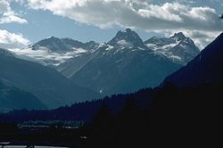
The Mount Meager massif in 1987. Summits left to right are Capricorn Mountain, Mount Meager and Plinth Peak.
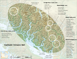
The location and extent of the Garibaldi Volcanic Belt, showing its isolated volcanoes and related volcanic features.
Location
British Columbia, Canada
Geology
Lava flows[1]
lava domes[2]
cinder cones[3]
stratovolcanoes[4]
subglacial volcanoes[5]
volcanic plugs[6]
calderas[7]
The Garibaldi Volcanic Belt is a northwest–southeast trending volcanic chain in the Pacific Ranges of the Coast Mountains that extends from Watts Point in the south to the Ha-Iltzuk Icefield in the north. This chain of volcanoes is located in southwestern British Columbia, Canada. It forms the northernmost segment of the Cascade Volcanic Arc, which includes Mount St. Helens and Mount Baker.[8][9] Most volcanoes of the Garibaldi chain are dormant stratovolcanoes and subglacial volcanoes that have been eroded by glacial ice. Less common volcanic landforms include cinder cones, volcanic plugs, lava domes and calderas. These diverse formations were created by different styles of volcanic activity, including Peléan and Plinian eruptions.
Eruptions along the length of the chain have created at least three major volcanic zones. The first began in the Powder Mountain Icefield 4.0 million years ago. Mount Cayley began its formation during this period. Multiple eruptions from 2.2 million to 2,350 years ago created the Mount Meager massif, and eruptions 1.3 million to 9,300 years ago formed Mount Garibaldi and other volcanoes in the Garibaldi Lake area. These major volcanic zones lie in three echelon segments, referred to as the northern, central, and southern segments.[10] Each segment contains one of the three major volcanic zones. Apart from these large volcanic zones, two large poorly studied volcanic complexes lie at the northern end of the Pacific Ranges, namely Silverthrone Caldera and Franklin Glacier Complex. They are considered to be part of the Garibaldi Volcanic Belt, but their tectonic relationships to other volcanoes in the Garibaldi chain are unclear because of minimal studies.[7][11]
^"Tricouni Southwest". Catalogue of Canadian volcanoes. Natural Resources Canada. 2009-03-10. Archived from the original on 2010-12-11. Retrieved 2010-03-04.
^"Columnar Peak". Catalogue of Canadian volcanoes. Natural Resources Canada. 2009-03-10. Archived from the original on 2006-02-19. Retrieved 2010-03-04.
^"Opal Cone". Catalogue of Canadian volcanoes. Natural Resources Canada. 2009-03-10. Archived from the original on 2006-02-19. Retrieved 2010-03-04.
^"Mount Price". Catalogue of Canadian volcanoes. Natural Resources Canada. 2009-03-10. Archived from the original on 2009-06-28. Retrieved 2010-03-04.
^"Slag Hill". Catalogue of Canadian volcanoes. Natural Resources Canada. 2009-03-10. Archived from the original on 2010-12-12. Retrieved 2010-03-04.
^"Sham Hill". Catalogue of Canadian volcanoes. Natural Resources Canada. 2009-03-10. Archived from the original on 2010-12-11. Retrieved 2010-03-04.
^ ab"Silverthrone Caldera". Catalogue of Canadian volcanoes. Natural Resources Canada. 2009-03-10. Archived from the original on 2010-12-12. Retrieved 2010-03-04.
^Cite error: The named reference JP was invoked but never defined (see the help page).
^"Garibaldi volcanic belt". Catalogue of Canadian volcanoes. Natural Resources Canada. 2009-04-02. Archived from the original on 2011-05-28. Retrieved 2010-02-20.
^Wood, Charles A.; Kienle, Jürgen (1990). Volcanoes of North America: United States and Canada. Cambridge, England: Cambridge University Press. pp. 112, 113, 140, 141, 142, 143, 144, 145, 136, 137, 138, 148. ISBN 0-521-43811-X.
^"Franklin Glacier". Catalogue of Canadian volcanoes. Natural Resources Canada. 2009-03-10. Archived from the original on 2010-12-11. Retrieved 2010-02-20.
and 27 Related for: Garibaldi Volcanic Belt information
The GaribaldiVolcanicBelt is a northwest–southeast trending volcanic chain in the Pacific Ranges of the Coast Mountains that extends from Watts Point...
Both were volcanically active at different times throughout Mount Garibaldi's eruptive history. The northern and eastern flanks of Mount Garibaldi are obscured...
Cascadia subduction zone. The GaribaldiVolcanicBelt includes the Bridge River Cones, Mount Cayley, Mount Fee, Mount Garibaldi, Mount Price, Mount Meager...
the massif. The GaribaldiVolcanicBelt (GVB) has a long history of eruptions and poses a threat to the surrounding region. Any volcanic hazard ranging...
end least active. The GaribaldiVolcanicBelt is the northern extension of the Cascade Arc. Volcanoes within the volcanicbelt are mostly stratovolcanoes...
Glacier Complex, the Pemberton VolcanicBelt merges with the GaribaldiVolcanicBelt, a northwest-trending belt of volcanic cones and fields extending from...
original on May 7, 2008. Retrieved January 22, 2009. "Garibaldivolcanicbelt: Garibaldi Lake volcanic field". Catalogue of Canadian volcanoes. Geological...
best known mountains in the Garibaldi Ranges of the Coast Mountains. The volcano is part of the GaribaldiVolcanicBelt which is a segment of the Canadian...
volcanoes in the Mount Cayley volcanic field. This volcanic zone forms the central portion of the larger GaribaldiVolcanicBelt, which extends from the Silverthrone...
and one of four overlapping volcanic cones which together form a large volcanic complex in the GaribaldiVolcanicBelt of the Canadian Cascade Arc. It...
The Alert Bay VolcanicBelt is a heavily eroded Neogene volcanicbelt in northern Vancouver Island, British Columbia, Canada. The belt is now north of...
its origins in the Cascadia subduction zone. Volcanoes of the GaribaldiVolcanicBelt have been sporadically active over a time span of several millions...
summit in the centre. List of volcanoes in Canada Cascade Volcanoes GaribaldiVolcanicBelt Volcanism of Canada Volcanism of Western Canada "Capricorn Mountain"...
exploration has taken place there for the last four decades. Part of the GaribaldiVolcanicBelt, Mount Cayley was formed by subduction zone volcanism along the...
the Squamish River mouth. It forms the southernmost end of the GaribaldiVolcanicBelt, which comprises part of the Canadian Cascade Arc. Its volcanoes...
The Garibaldi Lake volcanic field is a volcanic field, located in British Columbia, Canada. It was formed by a group of nine small andesitic stratovolcanoes...
lakes of British Columbia Cascade Volcanoes Garibaldi Lake volcanic field GaribaldiVolcanicBeltGaribaldi Provincial Park Mathews, W. H. (1956). "Physical...
of a tributary of Noel Creek. It is 150 km (93 mi) east of the GaribaldiVolcanicBelt and is made up of flat-lying, columnar-jointed basalt flows along...
of the Garibaldi Massif which is an eroded stratovolcano formed during the last ice age. The volcano is also part of the GaribaldiVolcanicBelt which...
GaribaldiVolcanicBelt was from the Mount Meager massif 2,350 BP, which is Canada's most recent major catastrophic eruption. The GaribaldiVolcanic Belt...
Bridge River. It is part of a volcanic group called the Bridge River Cones which in turn is part of the GaribaldiVolcanicBelt of the Canadian Cascade Arc...
Beach. It is the southernmost volcanic zone in the Squamish volcanic field and of the Garibaldi segment of the Cascade Volcanic Arc. The latest research indicates...
Squamish River. It forms a segment of the GaribaldiVolcanicBelt, the Canadian portion of the Cascade Volcanic Arc, which extends from Northern California...
 Global Information