Matagorda Island signSunset on Matagorda Island, Texas.
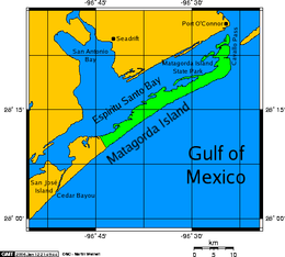
Matagorda Island (/ˌmætəˈɡɔːrdə/ⓘ[1]), Spanish for "thick bush," is a 38-mile (61 km) long barrier island on the Texas Gulf coast, located approximately seven miles (11 kilometers) south of Port O'Connor, in the southernmost part of Calhoun County. The traditional homeland of the Karankawa people, the island is oriented generally northeast-southwest, with the Gulf of Mexico on the east and south, and Espiritu Santo Bay on the west and north. It is separated from San José Island to the south by Cedar Bayou, and is separated from the Matagorda Peninsula to the north by Pass Cavallo. It is accessible by boat only. It has a land area of 60.7 square miles (157 square kilometers).
Matagorda Island State Park occupies 7,325 acres (2,964 hectares) on the northeastern end of the island. The remainder of the island is devoted to wildlife refuges managed by the Texas Parks and Wildlife Department and the United States Fish and Wildlife Service and is known as Matagorda Island National Wildlife Refuge and State Natural Area.[2]
The land that is now Matagorda Island State park was acquired in 1940 by condemnation from the Hawes, Hill, and Little families (but not the Wynne-Murchison interests) for use as a temporary training facility for the World War II era.[3]
Matagorda Island State Park was featured as a "survival location" by the main characters in the book Day by Day Armageddon by J.L. Bourne. The island is also featured as a principal location in the book Powersat by Ben Bova. Life on the island in the late 1800s is described in the book A Texas cowboy, or, Fifteen years on the hurricane deck of a Spanish pony by Charles A. Siringo
^"Matagorda Bay". Dictionary.com. Random House, Inc. Retrieved November 9, 2014.
^"Matagorda Island (WMA)". Texas Parks and Wildlife Department. Retrieved May 29, 2020.
MatagordaIsland (/ˌmætəˈɡɔːrdə/ ), Spanish for "thick bush," is a 38-mile (61 km) long barrier island on the Texas Gulf coast, located approximately seven...
The MatagordaIsland Light is located on MatagordaIsland in Calhoun County, in the U.S. state of Texas. Once under the jurisdiction of the United States...
Matagorda Peninsula Army Airfield is a closed military airfield, located on MatagordaIsland, Texas. It was used during World War II as a training airfield...
MatagordaIsland Air Force Base (/ˈmætəˈɡɔːrdə/ ) is a closed military airfield on the north end of MatagordaIsland, northeast of Corpus Christi, Texas...
Texas Matagorda Independent School District in Matagorda County, Texas MatagordaIsland, a barrier island on the coast of Texas MatagordaIsland State...
Matagorda Bay (/ˌmætəˈɡɔːrdə/ ) is a large Gulf of Mexico bay on the Texas coast, lying in Calhoun and Matagorda counties and located approximately 80...
Padre Island is the largest of the Texas barrier islands and the world's longest barrier island. The island is located along Texas's southern coast of...
Station Saluria MatagordaIsland Coast Guard Station San Luis Pass Galveston Coast Guard Station South Padre Island South Padre Island Coast Guard Station...
Mustang Island is a barrier island on the Gulf Coast of Texas in the United States. The island is 18 miles (29 km) long, stretching from Corpus Christi...
Galveston Island (/ˈɡælvɪstən/ GAL-vis-tən) is a barrier island on the Texas Gulf Coast in the United States, about 50 miles (80.5 km) southeast of Houston...
separates San Jose Island from MatagordaIsland. The pass serves as a water exchange between the Gulf of Mexico and the San Antonio, Matagorda and Aransas Bay...
Santo Bay and colonizing MatagordaIsland. Descendants of the Powder Horn Ranch boars were later released onto San José Island and the coast of Chalmette...
This is a list of islands of the United States, as ordered by area. It includes most islands with an area greater than 20 square miles (approximately 52...
South Padre Island is a barrier island in the U.S. state of Texas. The remote landform is located in Cameron County, Willacy County, and accessible by...
Dewberry Island is an island located in Espiritu Santo Bay in Calhoun County, Texas, in the United States. It is northeast of the MatagordaIsland Wildlife...
Guadalupe Estuary (San Antonio Bay), the Colorado–Lavaca Estuary (Matagorda Bay), East Matagorda Bay, the San Bernard River and Cedar Lakes Estuary, the Brazos...
southeast of San Antonio. It is protected from the Gulf of Mexico by MatagordaIsland, leaving only relatively small and distant outlets to the Gulf for...
of Engineers, Matagorda Ship Channel, Texas: Jetty Stability Study McAlister, Wayne H.; McAlister, Martha K. (1993). MatagordaIsland: A Naturalist's...
the only one that still stands. To distinguish it from the nearby MatagordaIsland Light it was given a red glass chimney to be used with the oil lantern...
the hurricane produced a maximum storm surge of 8.8 ft (2.7 m) at MatagordaIsland, Texas. Heavy rains produced by Bret peaked at 13.18 in (335 mm) in...
Salle resulted in his establishing the colony of Fort Saint Louis at Matagorda Bay rather than along the Mississippi River. The colony lasted only four...
 Global Information