Oceanic trench in the South China Sea, west of Luzon and Mindoro in the Philippines
1972
1956
1934
1924
1999
1972
1942
class=notpageimage|
Epicenters of large earthquakes ≥ 6.4 Mw along the Manila Trench, from 1924,[1] 1934,[2] 1942,[3] 1956,[4] 1972,[5][6] and 1999.[7]
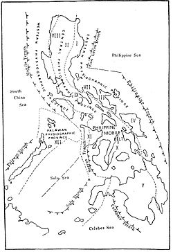
The Manila Trench near western Luzon and Mindoro, the Philippine Trench in the east, and the Philippine Mobile Belt.
The Manila Trench is an oceanic trench in the Pacific Ocean, located west of the islands of Luzon and Mindoro in the Philippines. The trench reaches a depth of about 5,400 metres (17,700 ft),[8] in contrast with the average depth of the South China Sea of about 1,500 metres (4,900 ft). It is created by subduction, in which the Sunda Plate (part of Eurasian Plate) is subducting under the Philippine Mobile Belt, producing this almost N-S trending trench. The convergent boundary is terminated to the north by the Taiwan collision zone, and to the south by the Mindoro terrane (Sulu-Palawan block colliding with SW Luzon). It is an area pervaded by negative gravity anomalies.[9]
The Manila Trench is associated with frequent earthquakes, and the subduction zone is responsible for the belt of volcanoes on the west side of the Philippine island of Luzon, which includes Mount Pinatubo.
Convergence between the Philippine Mobile Belt and the Sunda Plate have been estimated using GPS measurements, and this value ranges from ~ 50+ mm/yr in Taiwan, to 100 mm/yr near N. Luzon, and ~ 50 mm/yr near Zambales and ~20+mm/yr near Mindoro island.[10] Plate locking between the Sunda Plate and Luzon is about 1% coupled, almost unlocked as determined by elastic block models, suggesting that the trench absorbs the Philippine Mobile Belt-Eurasian Plate convergence.[11][clarification needed]
^"M 6.7 - Luzon, Philippines". United States Geological Survey. Retrieved March 15, 2018.
^"M 7.5 - Philippine Islands region". United States Geological Survey. Retrieved March 15, 2018.
^"M 7.4 - Mindoro, Philippines". United States Geological Survey. Retrieved March 15, 2018.
^"M 6.4 - Philippine Islands region". United States Geological Survey. Retrieved March 15, 2018.
^"M 6.7 - Philippine Islands region". United States Geological Survey. Retrieved March 15, 2018.
^"M 7.5 - Mindoro, Philippines". United States Geological Survey. Retrieved March 15, 2018.
^"M 7.3 - Luzon, Philippines". United States Geological Survey. Retrieved April 22, 2019.
1942 The ManilaTrench is an oceanic trench in the Pacific Ocean, located west of the islands of Luzon and Mindoro in the Philippines. The trench reaches...
archipelago. Subduction results in deep oceanic trenches, such as the Philippine Trench and ManilaTrench, which bound the eastern and western sides of...
Philippine Trench, which are 7.0+ Other known trenches in the Philippines are: ManilaTrench East Luzon Trench Negros Trench Sulu Trench Cotabato Trench Oceans...
Oceanic trenches are prominent, long, narrow topographic depressions of the ocean floor. They are typically 50 to 100 kilometers (30 to 60 mi) wide and...
Philippines. It includes two subduction zones, the ManilaTrench to the west and the Philippine Trench to the east, as well as the Philippine Fault System...
Metropolitan Manila (Filipino: Kalakhang Maynila), commonly shortened to Metro Manila and formally the National Capital Region (NCR; Filipino: Pambansang...
time, the magnitude would be Mw 9.1. In the South China Sea lies the ManilaTrench, which is capable of producing Mw 9.0 or larger earthquakes, with the...
of trenches along the western side of the Philippines formed over east-dipping subduction zones, including the ManilaTrench and the Negros Trench. At...
The 1863 Manila earthquake struck the Philippines on June 3, 1863. The Manila earthquake on June 3, 1863, destroyed Manila Cathedral, the Ayuntamiento...
the Philippine Trench and the East Luzon Trench. The Eurasian Plate is subducting under the Philippine Mobile Belt at the ManilaTrench. The Sunda Plate...
Bulacan in the north and runs through the provinces of Rizal, and the Metro Manila cities of Quezon, Marikina, Pasig, Taguig and Muntinlupa, and the provinces...
v t e Geography of the Philippines Geology Benham Rise Benham Bank ManilaTrench Marikina Valley Fault System Philippine Fault System Philippine Mobile...
the Eurasian Plate sliding under the Philippine Mobile Belt along the ManilaTrench to the west. Mount Pinatubo and the other volcanoes on this volcanic...
group, separated from Palawan Island of the Philippines by the Palawan Trench. Now completely submerged, with a depth of 20 metres (66 ft), it was an...
Philippine Trench. Off the west coast of Luzon, the ManilaTrench accommodates eastward subduction. To its east is the East Luzon Trench, a convergent...
cities and municipalities in the Philippines List of islands in the Greater Manila Area Lists of islands "Administrator Tiangco welcomes 2017". National Mapping...
Pansipit River Parañaque River Pasig River (Metro Manila) San Juan River Taguig River (Metro Manila) San Juan River San Cristobal River (Laguna) Santa...
known as the East Luzon Trench) is an oceanic trench north of the Philippine Trench and east of the island of Luzon. The trench is located near the Philippine...
(123 mi) west of Subic Bay. The 5,000–6,000 m (16,000–20,000 ft) deep ManilaTrench lies between the atoll and the Philippine island of Luzon to the east...
block situated in the western Philippines and the southern tip of the ManilaTrench. The North Palawan block is considered to form the northeastern portion...
of Miocene to recent volcanoes due to eastward subduction along the ManilaTrench for approximately 1,200 km from the Coastal Range in Taiwan south to...
Pangasinan, and Manila. Of the 40 injuries, 30 were reported in the provinces of Zambales and Pangasinan, while the other 10 were from the Manila metropolitan...
there due to the tsunami. The earthquake causing it was probably in the ManilaTrench. Historical record show that earthquake activity was largely cut off...
(February 1, 2017). "Tsunami simulation due to seaquake at ManilaTrench and Sulu Trench". Natural Hazards. 85 (3): 1723–1741. doi:10.1007/s11069-016-2661-x...
earthquake 2019 Visayas earthquake – occurred less than a day later ManilaTrench Philippine Trench "Earthquake Information - 22 Apr 2019 - 05:11:09 PM". PHIVOLCS...
v t e Geography of the Philippines Geology Benham Rise Benham Bank ManilaTrench Marikina Valley Fault System Philippine Fault System Philippine Mobile...
the China Sea Crust underneath the nearby ManilaTrench. The lack of accretionary prism at the Philippine Trench is suggestive of young origin correlating...
 Global Information